

TRMM Ground Validation
A key component of the TRMM project is the Ground Validation (GV) effort which consists of collecting data from ground-based radar, rain gauges and disdrometers. The data is quality-controlled, and then validation products are produced for comparison with TRMM satellite products.
The four primary GV sites are Darwin, Australia; Houston, Texas; Kwajalein, Republic of the Marshall Islands; and, Melbourne, Florida. A significant effort is also being supported at NASA Wallops Flight Facility (WFF) and vicinity to provide high quality, long-term measurements of rain rates (via a network of rain gauges collocated with National Weather Service gauges), as well as drop size distributions (DSD) using a variety of instruments, including impact-type Joss Waldvogel, laser-optical Parsivel, as well as two-dimensional video disdrometers. DSD measurements are also being collected at Melbourne and Kwajalein using Joss-Waldvogel disdrometers.
Products are produced using techniques developed to carefully control quality of ground radar data sets. The products estimate surface rainfall rates, adjusted by quality-controlled rain gauge data. The procedures for performing both quality-control and rainfall rate estimates take advantage of each site’s strengths.
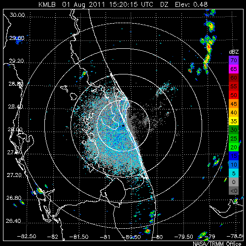
Example data from the WSR88D
Radar in Melbourne, FL.
The primary radar data quality control (QC) algorithm masks non-precipitation echoes by use of adjustable echo-height and reflectivity thresholds. Additional QC algorithms make use of signal quality and semi-permanent ground clutter sources. Rain gauge data QC is performed on several automated levels, one of which is a procedure to filter unreliable rain gauge data upon comparison to radar data.
To ensure GV data products are of the highest possible quality, dependent and independent rain gauge data (when available) are compared with radar estimates via scatter-plot analysis. Further analyses include time series comparisons of gauge and radar rain rates and detailed study of QC results. These efforts have resulted in standard validation data sets, at both instantaneous and monthly time scales. The validation data sets are compared to TRMM's satellite-based rain estimates and have helped to establish the accuracy of various TRMM products.
In addition, other specific gauge and disdrometer data sets are used to produce additional validation products. Recent upgrades of the dual-polarization radar at Kwajalein has allowed for quantitative estimation of drop size distributions, which are currently being used by TRMM satellite algorithms developers to improve their retrievals.
Detailed information and product analysis is available on the TRMM GV web site: http://trmm-fc.gsfc.nasa.gov/trmm_gv