

The GPM Constellation
Co-led by NASA and the Japan Aerospace and Exploration Agency (JAXA), the Tropical Rainfall Measurement Mission (TRMM) and Global Precipitation Measurement (GPM) mission have built unprecedented international cooperation in space asset sharing and scientific collaboration to advance precipitation estimation from space for research and applications.
GPM is an international satellite mission specifically designed to unify and advance precipitation measurements from research and operational microwave sensors for delivering next-generation global precipitation data products. The GPM mission concept centers on deploying a GPM “Core” satellite by NASA and JAXA carrying an advanced combined active/passive sensor package to establish new reference standards for precipitation measurements from space. The combined active/passive sensor measurements are also used to compute consistent precipitation estimates from this constellation of satellites provided by a consortium of international partners.
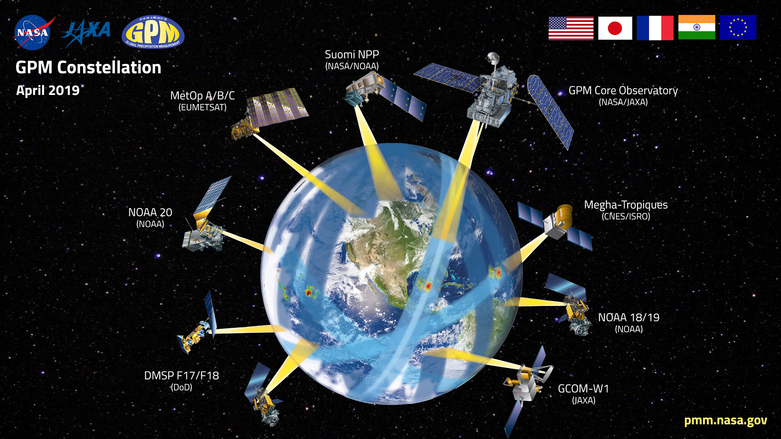
Diagram of the GPM satellite constellation as of early 2019. Credit: NASA GSFC
Bilateral agreements through either NASA or JAXA provide GPM with global coverage at a high sampling frequency by relying on both existing satellite programs and new mission opportunities developed by its partners. Each constellation member has its own scientific or operational objectives, but also contributes microwave measurements to GPM for the generation and dissemination of uniformly processed global precipitation products for user communities around the world.
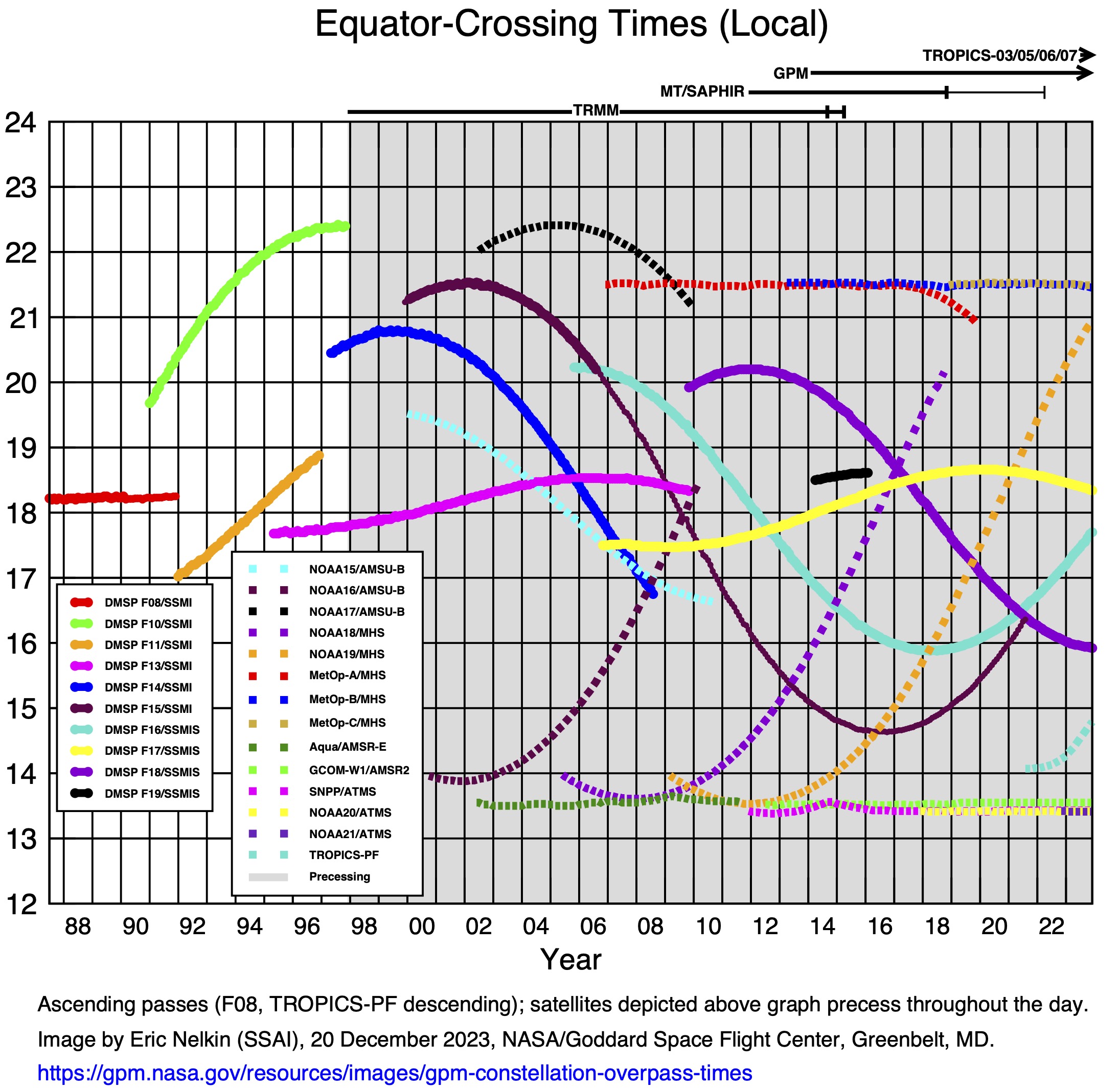
This graph depicts the overpass times and periods of record for satellites with microwave imagers / sounders. Updated Dec. 20, 2023. Credit: NASA GSFC
In addition to the DPR and GMI on the GPM Core Observatory, the GPM constellation satellites currently host several types of passive microwave (PMW) radiometers:
- The Advanced Microwave Scanning Radiometer-2 (AMSR-2) on JAXA’s Global Change Observation Mission - Water 1 (GCOM-W1) satellite.
- The Advanced Technology Microwave Sounder (ATMS) instruments on the Suomi National Polar-orbiting Partnership (SNPP) and NOAA20 satellites.
- The multi-channel microwave humidity sounder Sondeur Atmosphérique du Profil d’Humidité Intertropicale par Radiométrie (SAPHIR) on the Megha-Tropiques satellite provided by the Centre National D’Etudies Spatiales (CNES) of France and the Indian Space Research Organisation (ISRO.).
- The Microwave Humidity Sounder (MHS) instrument on the NOAA19 satellite.
- MHS instruments on the MetOp series of satellites launched by the European Organization for the Exploitation of Meteorological Satellites (EUMETSAT).
- Special Sensor Microwave Imager/Sounder (SSMIS) instruments on U.S. Defense Meteorological Satellite Program (DMSP) satellites.
The relatively high-quality precipitation estimates based on these PMW sensors is complemented by precipitation estimates based on infrared (IR) data recorded by geosynchronous weather satellites. Although less accurate, these IR data provide backup information when a location lacks PMW data for several hours. The geosynchronous satellites contributing across the TRMM and GPM mission are:
- GMS, MTSat, Himawari Series (JMA)
- GOES-E Series (NESDIS)
- GOES-W Series (NESDIS)
- Metosat Prime Series (EUMETSTAT)
- Meteosat Reposition Series (EUMETSAT)
Finally, where possible, GPM precipitation products include precipitation gauge information to adjust the satellite estimates. Specifically, analyses of monthly gauge accumulations computed by the Global Precipitation Climatology Centre are used to reduce the biases in monthly averages in regions where gauges are available.
In 2002 the United Nations Program on “Remote Sensing for Substantive Water Management in Arid and Semi-Arid Areas" identified the GPM Mission as an outstanding example of peaceful uses of space. Within the framework of the intergovernmental Group on Earth Observations (GEO) and Global Earth Observation System of Systems (GEOSS), GPM provides the cornerstone for developing the Precipitation Constellation under the auspices of the Committee of Earth Observation Satellites (CEOS) to provide comprehensive, long-term, and coordinated observations of the Earth. During its mission life, the constellation of satellites contributing to GPM is designated as the first realization of the CEOS Precipitation Virtual Constellation.