Vanuatu

IMERG Captures Rainfall from Tropical Cyclone Ana in Fiji
NASA combined data from multiple satellites to estimate the rainfall from Tropical Cyclone Ana in the Southwest Pacific Ocean amid an ongoing Madden-Julian Oscillation (MJO) event. The Madden-Julian Oscillation is a 20 to 90 day pattern of alternating wet and dry conditions that often begins in the tropical Indian Ocean and moves eastward into the Pacific. This animation shows rainfall rates (blue/yellow shading) and rainfall accumulations (green shading) at half-hourly intervals from January 26 - February 2, 2021, using NASA's IMERG algorithm, overlaid on shades of white/gray from NOAA

GPM Flies Over Category 4 Cyclone Harold in the South Pacific

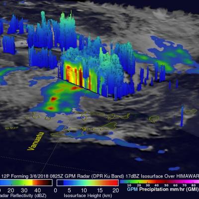
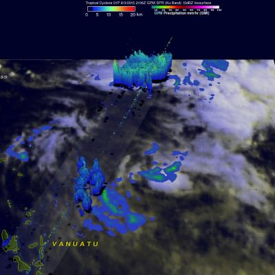
For more information or to download this public domain video, go to: https://svs.gsfc.nasa.gov/4812#29226 UPDATE 4/9/2020 This animation shows the heavy precipitation associated with Tropical Cyclone Harold as it progressed from the Solomon Islands (upper left) on April 2, 2020, explosively intensified on April 3, reached Vanuatu (center) as a Category 4 storm on April 5 before briefly attaining Category 5 status on April 6 and passing just south of Fiji (center right) on April 7 as a Category 4 storm. Periodically, Harold's core region produced precipitation rates in excess of 30 millimeters

GPM Observes Tropical Cyclone 12P Forming

On March 6, 2018 at 0825 UTC the GPM core observatory satellite flew above a forming tropical cyclone in the southern Pacific Ocean just east of Vanuatu. GPM's Dual Frequency Precipitation Radar (DPR) scanned storms in the center of forming tropical cyclone 12P's circulation. This view by GPM's DPR revealed that convective storms were dropping extremely heavy rainfall on the eastern edge of the forming tropical cyclone's low level center. DPR indicated that rain was falling at a rate of over 241 mm (9.5 inches) per hour in this area. The use of GPM satellite's radar data enabled this 3-D view

Weakening Tropical Cyclone Zena's Rain Measured By GPM

Heavy rain was reported as weakening tropical cyclone Zena passed quickly by Tonga. Tropical cyclone Zena was in the process of being torn apart with strong vertical wind shear. The GPM core observatory satellite passed above Zena on April 7, 2016 at 0841 UTC after the center of the tropical cyclone had moved to the east-southeast of Tonga. Zena's maximum sustained winds had dropped to about 35 kts (40 mph). Rainfall derived from GPM's Microwave Imager (GMI) data are shown overlaid on a 0900 UTC GOES-WEST enhanced infrared image. GPM's GMI revealed that weakening tropical cyclone Zena still

GPM Sees More Powerful Tropical Cyclone Zena

Tropical cyclone Zena intensified over the open waters between Vanuatu and Fiji. At peak intensity Zena had sustained winds estimated at about 90 kts (104 mph). The GPM core observatory satellite had an excellent view of tropical cyclone Zena on April 6, 2016 at 0933 UTC when tropical cyclone Zena was located southwest of Fiji. Zena had started to weaken but still had maximum sustained wind speeds estimated at 80 kts (92 kts). An analysis of GPM's Microwave Imager (GMI) and Dual-Frequency Precipitation Radar (DPR) data revealed the intensity of some very heavy showers in the tropical cyclone

GPM Views Tropical Cyclone Zena Hitting Vanuatu

Tropical Cyclone Zena (18P) formed in the South Pacific Ocean near Vanuatu early on April 5, 2016. The GPM core observatory satellite flew directly above the newly formed tropical cyclone on April 5, 2016 at 1023 UTC. Intensifying tropical cyclone Zena was buffeting Vanuatu with sustained winds estimated to be over 35 kts (40 mph). A rainfall analysis derived from GPM's Microwave Imager (GMI) and Dual-Frequency Precipitation Radar (DPR) instruments shows that very powerful storms moving through the islands were dropping rain at a rate of almost 154 mm (6 inches) per hour in intense downpours

GPM Views Rare Southern Hemisphere Tropical Cyclone

It is a little unusual to see a tropical cyclone forming in the southern Pacific Ocean this time of the year but tropical cyclone 01P formed northeast of Vanuatu recently. The GPM core observatory satellite saw Tropical Cyclone 01P on Monday August 3, 2015 at 2106Z (about 9:06 local time). GPM's Microwave Imager (GMI) found rain falling at a rate of over 30 mm (1.2 inches) per hour in a small area of showers near the center of the tropical cyclone. A 3-D view constructed from GPM's Dual-Frequency Precipitation Radar (DPR) instrument (Ku band) showed that some showers located between the

Cyclone Pam Departs Vanuatu

As one of the strongest cyclones every recorded in the South Pacific, Cyclone Pam devastated the island archipelago of Vanuatu. As the cyclone bore down on Vanuatu's central islands on the afternoon (local time) of March 13th, Pam's maximum sustained winds were estimated to have increased to 270 kph (~167 mph) by the US Joint Typhoon Warning Center (JTWC), making it a category 5 storm on the US Saffir-Simpson scale. The storm caused immense, widespread damage with the islands of Erromango and Tanna suffering a direct hit. Although damage is still being assessed, the number of reported