
John
GPM Passes Over Weakening Hurricane John
 JacobAdmin
Thu, 08/09/2018
JacobAdmin
Thu, 08/09/2018
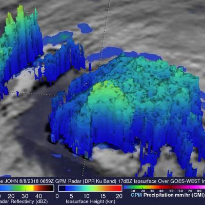
The GPM core observatory satellite provided very good coverage of hurricane JOHN when it passed above the eye of the tropical cyclone on August 8, 2018 at 0:59 AM MDT (0659 UTC). JOHN's maximum sustained wind speeds had started to decrease. GPM's Microwave Imager (GMI) and Dual-Frequency Precipitation Radar (DPR) instruments showed that most of JOHN's precipitation was then located in the eastern half of the hurricane. A large cloud free area had developed between the center of the hurricane and an intense feeder band wrapping around the northern and western side of the hurricane. GPM's radar
GPM Passes Over Weakening Hurricane John
JacobAdmin
Thu, 08/09/2018
The GPM core observatory satellite provided very good coverage of hurricane JOHN when it passed above the eye of the tropical cyclone on August 8, 2018 at 0:59 AM MDT (0659 UTC). JOHN's maximum sustained wind speeds had started to decrease. GPM's Microwave Imager (GMI) and Dual-Frequency Precipitation Radar (DPR) instruments showed that most of JOHN's precipitation was then located in the eastern half of the hurricane. A large cloud free area had developed between the center of the hurricane and an intense feeder band wrapping around the northern and western side of the hurricane. GPM's radar
GPM Views Tropical Storm John
 JacobAdmin
Mon, 08/06/2018
JacobAdmin
Mon, 08/06/2018
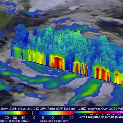
The GPM core observatory satellite had an extremely good view of tropical storm John on August 6, 2017 at 1:08 AM MDT (0708 UTC). The satellite passed right over John's center of circulation. GPM's Microwave Imager (GMI) and Dual-Frequency Precipitation Radar (DPR) instruments provided excellent coverage of precipitation associated with tropical storm John. GPM showed that the large tropical cyclone was becoming well organized and had intense rainfall within feeder bands that were spiraling toward John's center. GPM's radar (DPR Ku Band) revealed that a band of powerful storms northeast of