Donna

Tropical Cyclone Donna's Extreme Rainfall Evaluated With IMERG

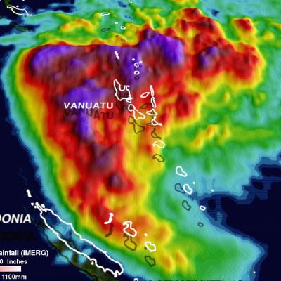
On May 10, 2017 rapidly dissipating tropical Cyclone Donna moved to the southeast of New Caledonia in the South Pacific. In addition to being the most powerful out-of-season tropical cyclone ever recorded in the southern hemisphere, Donna also dropped extreme amounts of rainfall along it's path. Donna spread heavy rainfall along it's path from northern Vanuatu through the Loyalty Islands east of New Caledonia. Over 250mm (~10 inches) of rainfall was reported in the islands of northern Vanuatu as Donna was moving through on May 5, 2017. This rainfall analysis was constructed using data from

GPM Monitors Tropical Cyclone Donna

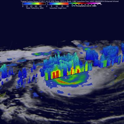
The above window displays an interactive visualization of GPM data collected from Tropical Cyclone Donna on 5/7/17. Over the weekend tropical cyclone Donna dropped very heavy rain over Vanuatu as it moved toward the west of the islands. Donna had intensified and had maximum sustained winds of 115 kts (132 mph) on Monday morning. This made it the equivalent of a category four on the Saffir-Simpson hurricane wind scale. The GPM core observatory satellite had two excellent views of the intensifying tropical cyclone Donna on succeeding days. When GPM flew over Donna on May 6, 2017 at 0146 UTC the

Tropical Cyclone Donna's Rain Unveiled By GPM

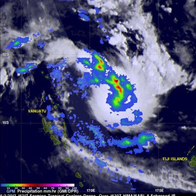
Tropical Cyclone Donna formed in the South Pacific Ocean northeast of Vanuatu On May 2, 2017 at 1800 UTC. A few hours earlier at 1521 UTC the GPM core observatory satellite passed above that area. GPM's Microwave Imager (GMI) instrument provided a clear view of the rainfall associated with the forming tropical cyclone. GMI revealed that an intense rain band was wrapping into the center of the forming tropical cyclone from the northern side. GMI data indicated that precipitation in one of these intense rain bands was falling at a rate of over 53 mm (~2 inches) per hour. GPM's Dual-Frequency