Bonnie

GPM Sees Tropical Depression Bonnie In The Atlantic

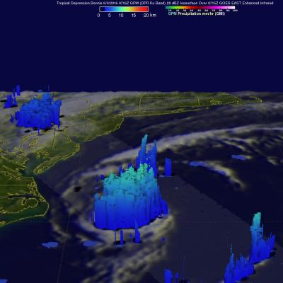
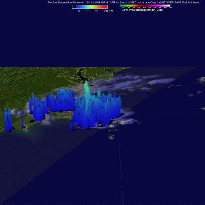
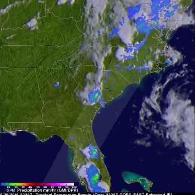
The GPM core Observatory had another good look at revived tropical Depression Bonnie on June 3, 2016 at 0716 UTC (3:16 AM EDT). Rainfall calculated from data received by GPM's Microwave Imager (GMI) and and Dual-Frequency Precipitation Radar (DPR) instruments are shown in the first image. Those instruments found that Bonnie was dropping rain at a rate of over 65 mm (2.6 inches) per hour in storms south of the depression's center of circulation. GPM's Radar (DPR Ku Band) again measured the 3-D structure of rainfall within Bonnie and found that some storms were reaching heights of over 13 km (8

Rainfall Causes Texas and Oklahoma Flooding

Continuing heavy rain has resulted in dangerous flooding conditions from Oklahoma through eastern Texas. The Brazos, Trinity and Colorado Rivers in Southeastern Texas are at or above flood stage. Flooding resulted in the deaths of at least 6 people in Texas during the past week. Governor Greg Abbott declared a state of disaster in 31 Texas counties. Over 20 inches of rainfall were reported in some areas since May 30, 2016. Parts of Georgia and the Carolinas were flooded by very slow moving tropical depression Bonnie. This estimate of rainfall totals from May 27, 2016 to June 2, 2016 was made

GPM Sees Bonnie as a Tropical Depression Again

Tropical storm Bonnie weakened to a tropical depression on May 29, 2016. The circulation was labeled as "Post-Tropical" and has been moving very slowly to the northeast near the Carolinas coastline. Bonnie developed organized convection near the center and the system has again been labeled a tropical depression. The GPM core observatory satellite saw Tropical Depression Bonnie on June 1, 2016 at 2226 UTC (6:26 PM EDT). GPM's Microwave Imager (GMI) and and Dual-Frequency Precipitation Radar (DPR) instruments measured precipitation in a few powerful convective thunderstorms falling at a rate of

GPM Examines Tropical Depression Bonnie In The Carolinas

The GPM core observatory satellite had an excellent view of Tropical Depression Bonnie as it flew over the southeastern United States on May 29, 2016 at 2326 UTC (7:26 PM EDT). Rainfall was analyzed using data collected by GPM's Microwave Imager (GMI) and and Dual-Frequency Precipitation Radar (DPR) instruments. GPM's radar (DPR) showed rain falling at a rate of over 25.4 mm (1 inch) per hour in South Carolina. GPM's Radar (DPR Ku Band) was able to see through cloud cover in the tropical depression and show the vertical shape of rain within storms. The heights of storm tops were derived from
Deadly Flooding Rainfall Over Texas And Tropical Storm Bonnie Measured From Space JacobAdmin Tue, 05/31/2016
Heavy rainfall caused deadly flooding in southeastern Texas. At least 4 people have been killed and continuing rainfall is expected to cause historic flooding in that area. Meanwhile, dissipating Tropical storm Bonnie is soaking the South Carolina coast, southeastern North Carolina and eastern Georgia on this Memorial Day weekend. Some flooding is expected as dissipating tropical storm Bonnie's rainfall moves northeastward along the coast. This analysis of liquid precipitation from space was accomplished by using merged satellite rainfall data from the TRMM Multi-satellite Precipitation