Carlos

GPM Sees Carlos Moving Past Reunion Island

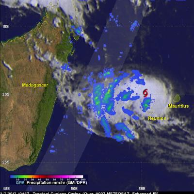
The GPM core observatory satellite flew above tropical cyclone Carlos on February 7, 2017 at 1056 UTC. Carlos was moving past Reunion Island with maximum sustained winds estimated at 45 kts (51.8 mph). GPM's Microwave Imager (GMI) and Dual-Frequency Precipitation Radar (DPR) data show that rain bands west of Carlos' center were producing heavy rainfall. GPM's DPR swath is shown in a lighter shade. DPR measured a few downpours in the bands west of the Carlos' center of circulation dropping rain at a rate of over 120 mm (4.7 inches) per hour. GPM's radar (DPR Ku Band) found that a few storm tops

Tropical Storm Carlos Forms

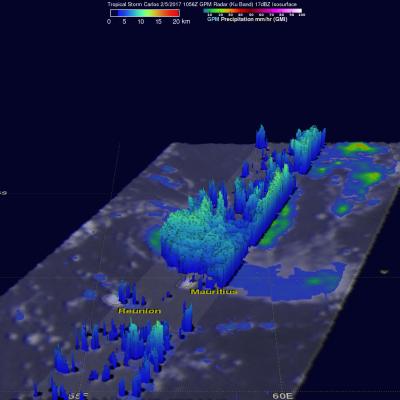
Tropical storm Carlos formed in the Southwest Indian Ocean north of the French Islands of Reunion and Mauritius on February 4, 2017 (UTC). This ended an unusual drought of tropical cyclone formation in that part of the Indian Ocean that began in July 2016. NASA's GPM core observatory satellite flew above tropical storm Carlos on February 5, 2017 at 1056 UTC when Carlos had maximum sustained winds of about 45 kts (51.8 mph). GPM collected data that showed the intensity and structure of precipitation within Carlos. GPM's Dual-Frequency Precipitation Radar (DPR) measured rain falling at a rate of

Tropical Storm Carlos Viewed By GPM

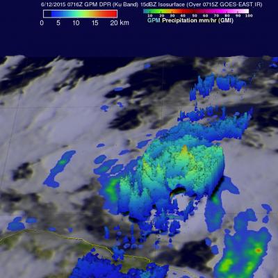
Tropical storm Carlos is the third tropical cyclone in what promises to be a busy 2015 eastern Pacific hurricane season. The GPM core observatory satellite flew directly above Carlos on June 12, 2015 at 0716 UTC. GPM's Microwave Imager (GMI) and Dual-Frequency Precipitation Radar (DPR) instruments showed that heavy rain was falling in a band of powerful storms to the southeast of the tropical storm's center of circulation. Rainfall was measured by GPM radar (Ku band) falling at a rate of almost 70 mm (2.8 inches) per hour in Carlos' most intense areas of rainfall. Those same radar data were