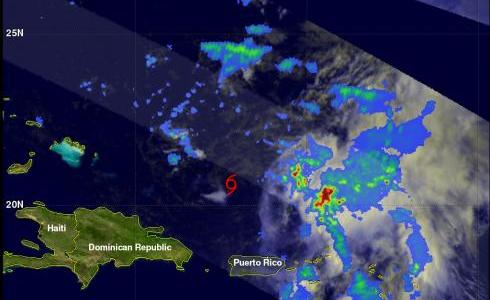
TRMM Sees Disorganized Tropical Storm Maria
The TRMM satellite passed over tropical storm Maria on 12 September 2011 at 1249 UTC (8:49 AM EDT). This TRMM pass shows that tropical storm Maria's center of circulation was exposed and displaced well to the west of deep convection. A red tropical storm symbol was overlaid on the image derived from this TRMM pass to show the location of Maria's center of circulation. With this pass TRMM's Precipitation Radar (PR), shown in the lighter swath, scanned directly above the deep convection east of Maria's center. Those data showed that some rainfall in this area was very intense with rates of over 50 mm/hr (~2 inches).
Due to a lack of organization and westerly to south-westerly shear in the future, the National Hurricane Center (NHC) has predicted that Maria's wind speeds will only increase slightly to about 50kts ( ~57.5 mph) in the next 36 hours. Maria is expected to then move harmlessly over the open waters of the Atlantic Ocean between the east coast of the United States and Bermuda.


