
Strong Storms Bring Heavy Rain, Flooding to Upper Midwest
An upper-level trough of low-pressure dropping down out of the Canadian Rockies in combination with a persistent frontal boundary and high pressure over the Southeast, combined to bring about strong storms and flooding over the Upper Midwest. The storms brought the worst flooding on record to Duluth, Minnesota where as much as 10 inches of rain were reported over a 2-day period from 19th to the 20th of June, resulting in flash flooding and many washed out roads. Even the zoo was flooded. Washed out roads were blamed for 3 fatalities in nearby Wisconsin.
Counter-clockwise flow around high pressure over the southeastern United States allowed warm, moist air to flow from the Gulf of Mexico up through the Mississippi Valley and into the north, central part of the country, providing fuel for storms. A series of frontal boundaries provided the focus and trigger for these storms, while an upper-level trough brought additional lift that enhanced the storms. A passing squall line associated with an advancing warm front brought between a half to an inch and half of rain to much of Minnesota and the northern two thirds of Wisconsin during the night of the 17th and morning of the 18th. Storms again broke out on the 19th north of a stationary front draped across southern Minnesota and central Wisconsin. A line of storms persisted north of the front on the morning of the 20th as low pressure moved along the front up through central Minnesota. By the evening of the 20th, a large squall extending from the northern Great Lakes down into southeastern Nebraska was advancing out of Minnesota and across Wisconsin, bringing additional heavy rain to the region.
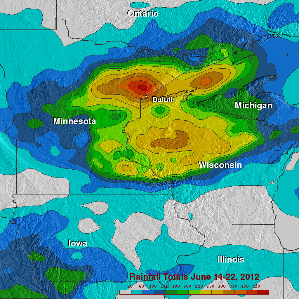
With its combination of passive microwave and active radar sensors, the Tropical Rainfall Measuring Mission satellite (better known as TRMM) is ideally suited to measure rainfall from space. For increased coverage, TRMM can be used to calibrate rainfall estimates from other additional satellites. The TRMM-based, near-real time Multi-satellite Precipitation Analysis (TMPA) at the NASA Goddard Space Flight Center can be used to rainfall over a wide portion of the globe. TMPA rainfall totals are shown here for the 8-day period 14 to 22 June 2012 for the Upper Midwest. TMPA rainfall estimates show upwards of between 180 and 220 mm of rain (~7 to 9 inches, shown in green and yellow, respectively) over most of eastern Minnesota and northern Wisconsin. The highest totals, however, occur in northeastern Minnesota just north of Duluth and range anywhere from 300 mm (~12 inches, shown in brown) to over 420 mm of rain (~16.5 inches, shown in red).