Extreme Weather News

Jump to a Year

2022 | 2021 | 2020 | 2019 | 2018

2017 | 2016 | 2015 | 2014 | 2013

2012 | 2011 | 2010 | 2009 | 2008

2007 | 2006 | 2005 | 2004 | 2003

2002

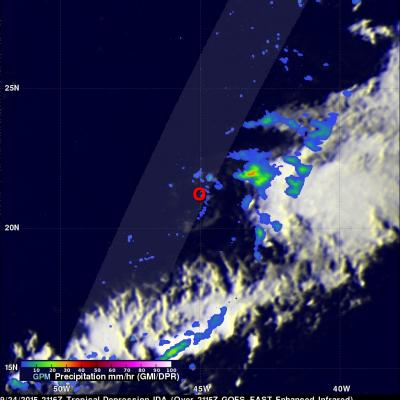
GPM Monitors New Tropical Storm Niala

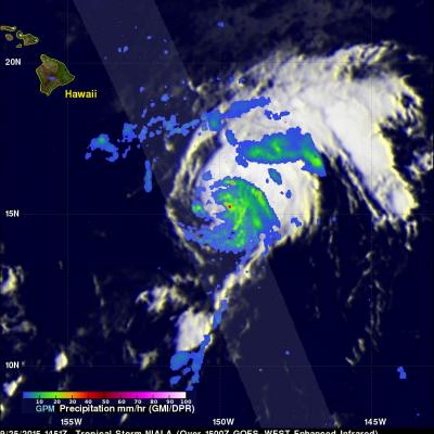
The GPM core observatory satellite flew directly above newly formed tropical storm NIALA (06C) on September 25, 2015 at 1451 UTC (4:41 AM HST). Rainfall data were collected by GPM's Microwave Imager (GMI) and Dual-Frequency Precipitation Radar (DPR) instruments showing that intense storms just northeast of NIALA's center of circulation were dropping rain at a rate of over 126 mm (4.96 inches) per hour. Another rain band wrapping around NIALA's northeastern side was found to contain rain falling at a rate of over 56 mm (2.2 inches) per hour. 3-D radar reflectivity data collected by GPM's radar

Ida Weakened by Strong Shear in the Atlantic

Tropical Depression Ida has struggled to maintain itself in the Central Atlantic well east of the Leeward Islands where it has been ravaged by strong wind shear. Since forming back on the 18th of September, Ida has not been able to strengthen beyond a moderate tropical storm, reaching a peak intensity of 45 knots (50 mph) early on the morning of the 21st before succumbing to the effects of strong northwesterly winds from an upper-level trough. Since that time, Ida has struggled maintain itself between a depression and a weak tropical storm, while being mired in the Central Atlantic. This most

Meandering Ida's Precipitation Measured By GPM

The GPM core observatory satellite had another good view of meandering tropical storm Ida located in the central Atlantic Ocean on September 24, 2015 at 0756 UTC (3:35 AM EDT). Measurements of precipitation by GPM's Microwave Imager (GMI) and Dual-Frequency Precipitation Radar (DPR) instruments showed that Ida still contained a few embedded strong convective thunderstorms that were dropping heavy rainfall. Some rainfall was measured by GPM's Ku Band radar falling at a rate of 122 mm (4.8 inches) per hour. GPM's 3-D radar reflectivity data (DPR Ku band) can be used to reveal the intensity of
https://www.youtube.com/watch?v=8eIwMXnU8IA&feature=youtu.be
A narrated visualization of Typhoon Kilo. Click here for a full transcript. Click here to download this video in high resolution from the NASA Goddard Scientific Visualization Studio. The Global Precipitation Measurement (GPM) mission core satellite provided many views of Tropical Cyclone Kilo over its very long life. GPM is a satellite co-managed by NASA and the Japan Aerospace Exploration Agency that has the ability to analyze rainfall and cloud heights. GPM was able to provide data on Kilo over its 21 day life-span. The GPM core observatory satellite flew over Kilo on August 25, 2015 at...

GPM Sees Powerful Storms Within Tropical Storm Ida

The GPM core observatory satellite found that tropical Storm IDA contained some very powerful convective thunderstorms when the satellite passed over on September 21, 2015 at 0902 UTC (05:02 AM EDT). The satellite passed directly above the most powerful storms within IDA where rain was measured by GPM's Microwave Imager (GMI) and Dual-Frequency Precipitation Radar (DPR) instruments. DPR found that some thunderstorms were dropping rain at a rate of over 142 mm (5.6 inches) per hour. GPM's DPR (Ku Band) radar data were used examine the 3-D structure of precipitation within tropical storm IDA