Extreme Weather News

Jump to a Year

2022 | 2021 | 2020 | 2019 | 2018

2017 | 2016 | 2015 | 2014 | 2013

2012 | 2011 | 2010 | 2009 | 2008

2007 | 2006 | 2005 | 2004 | 2003

2002

Tropical Storm Patricia Forms Off Mexican Coast

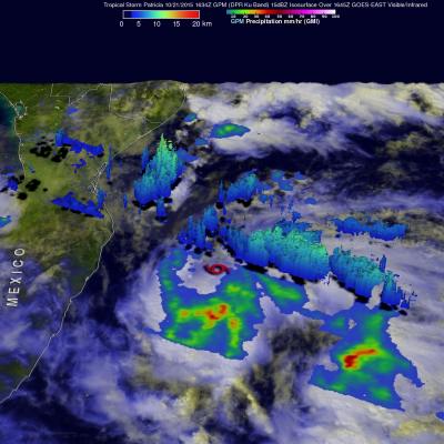
Tropical Depression Twenty-E (TD20E) formed on October 20, 2015 off the Mexican coast southeast of Puerto Escondido, Mexico. Later that evening TD20E was upgraded to tropical storm Patricia. On October 21, 2015 at 1634 UTC (11:34 AM CDT) the GPM core observatory satellite flew over tropical storm Patricia. GPM's Microwave Imager (GMI) instrument had good coverage of the rainfall associated with the tropical storm. Rainfall data derived from GMI are shown overlaid on a GOES-EAST Visible/Infrared image captured at 1645 UTC (11:45 AM CDT). GPM's Dual-Frequency Precipitation Radar (DPR) instrument

GPM Checks on Cat 4 Hurricane Olaf

On October 19, 2015 Hurricane Olaf became the eighth category four hurricane in the busy 2015 Eastern Pacific hurricane season. The GPM core observatory satellite had a good look at the distribution of rainfall around powerful hurricane Olaf on October 20, 2015 at 0716 UTC. At that time Olaf had sustained winds estimated at over 130 kts (150 mph). GPM's Microwave Imager (GMI) and Dual-Frequency Precipitation Radar (DPR) measured the intensity of rainfall within the hurricane. GPM's GMI found rain falling at a rate of over 71.5 mm (2.8 inches) per hour in Olaf's eye wall. The DPR instrument

Typhoon Koppu's Deadly Philippine Rainfall

Extremely heavy rainfall from super typhoon Koppu has caused deadly flooding and mudslides in the Philippines. Koppu hit the eastern coast of Luzon as a category four super typhoon with winds of 130kts (150 mph). Koppu weakened but was still battering the Philippines as a typhoon after reaching the Lingayen Gulf on Luzon's western coast. Typhoon Koppu then made a turn toward the north and continued to drench the northern Philippines as it followed Luzon's northwestern coast. Torrents of rain flowing from mountainous terrain magnified the effects of very high rainfall totals. A rainfall

GPM Measures Tropical Storm Champi's Heavy Rainfall

On October 16, 2015 at 0216 UTC the GPM core observatory satellite passed above tropical storm Champi as it was drenching the northern Mariana Islands. GPM's Dual-Frequency Precipitation Radar (DPR) measured rain within Champi falling at a rate of over 114.8 mm (4.5 inches) per hour in a band of intense showers. GPM's radar sliced through Champi's western side and made 3-D measurements of storm top heights. Radar reflectivity values found to be greater than 15 dBZ are shown in a simulated perspective 3-D view. The lowest Heights are shaded blue and the tallest 3-D 15dBZ surfaces are colored

GPM Sees Tropical Storm Koppu Menacing The Philippines

Tropical storm Koppu was approaching the Philippines with sustained winds estimated of 60 kts (69 mph) when the GPM core observatory satellite passed above on October 15, 2015 at 1436 UTC. A rainfall analysis using data collected by GPM's Microwave Imager (GMI) instrument revealed that an eye was very close to forming near Koppu's center of circulation. Rain was measured by GPM's GMI instrument dropping rain at a rate of over 133 mm (5.3 inches) per hour in intense convective thunderstorms just southwest of Koppu's center. Data from GPM's Dual-Frequency Precipitation Radar (DPR) instrument