Extreme Weather News

Jump to a Year

2022 | 2021 | 2020 | 2019 | 2018

2017 | 2016 | 2015 | 2014 | 2013

2012 | 2011 | 2010 | 2009 | 2008

2007 | 2006 | 2005 | 2004 | 2003

2002

Tropical Storm Rick Examined By GPM

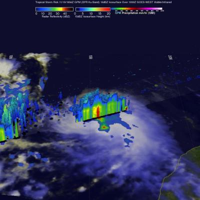
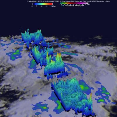
Tropical storm Rick is the latest tropical cyclone to form in the 2015 Eastern Pacific Ocean hurricane season which has spawned a record number of dangerous hurricanes. Tropical storm Rick was moving over the eastern Pacific Ocean well off the Mexican coast when the GPM core Observatory satellite flew over on November 19, 2015 at 1956 UTC. Data captured by GPM's Microwave Imager (GMI) and Dual-Frequency Precipitation Radar (DPR) show that tropical storm Rick had a couple areas near the center of circulation that were dropping rain at a rate of over 41.6 mm (1.6 inches) per hour. GPM's radar

GPM Sees Better Organized Typhoon IN-FA

The GPM core observatory satellite had another excellent view of typhoon IN-FA on November 19, 2015 at 0305 UTC. This GPM pass revealed the location of typhoon IN-FA's eye beneath dense overcast. Rainfall derived from data collected by GPM's Microwave Imager (GMI) and Dual-Frequency Precipitation Radar (DPR) instruments show that feeder bands around IN-FA were getting better organized. The most intense precipitation was measured in IN-FA's eye wall by DPR where it was falling at a rate of almost 55 mm (2.16 inches) per hour. Most rainfall in feeder bands was shown by GPM to be only light to

GPM Monitors Western Pacific Typhoon IN-FA

On November 18, 2015 at 1533 the GPM core observatory satellite flew directly over a recently formed typhoon called IN-FA that was located near the Equator well to the southeast of Guam. Favorable environmental conditions such as low vertical wind shear and warm sea surface temperatures helped typhoon IN-FA intensify quickly from a tropical depression on November 17 to a typhoon on November 18, 2015. Rainfall from GPM's Microwave Imager (GMI) and Dual-Frequency Precipitation Radar (DPR) instruments were used to analyze the rainfall around typhoon IN-FA. GPM's DPR found that rain was falling at

India's Deadly Flooding Rains Measured By IMERG

During the past week extreme rainfall from two unnamed slow moving tropical lows has causing severe flooding in southern India. This flooding has caused the reported deaths of as many as 71 people. The city of Chennai in the state of Tamil Nadu has been hit exceptionally hard with 59 people people killed. NASA's Integrated Multi-satellite Retrievals for GPM (IMERG) combines all data from 12 satellites into a global map of rainfall at half hourly intervals. The rainfall accumulation analysis above was computed from data generated by IMERG during the past week from November 9-16, 2015. An

Tropical Storm Kate Examined By GPM

Kate became the twelfth named tropical cyclone of the of the 2015 Atlantic hurricane season when it formed near the southeastern Bahamas on Sunday November 8, 2015. Kate re-curved toward the northeast and moved harmlessly over the open waters of the Atlantic. Kate's intensity peaked on November 11, 2015 with winds of about 65 kts making it a category one hurricane on the Saffir-Simpson Hurricane. The GPM core observatory satellite flew above Kate on November 11, 2015 at 0926 UTC (4:26 AM EST) capturing data used in these images. Kate's maximum sustained winds were estimated at about 60 kts (69