
Yemen Hit by 2nd Tropical Cyclone in a Week
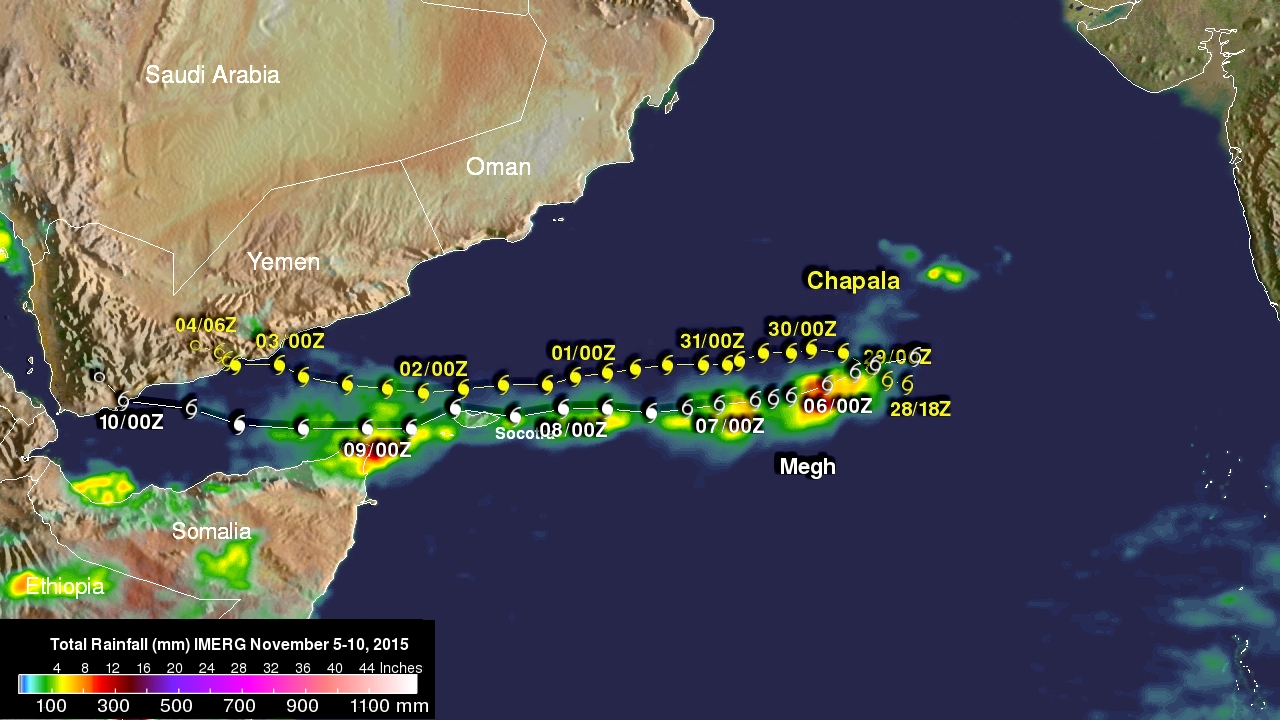
One week ago to the day Cyclone Chapala, the first Category 1 cyclone to strike Yemen in recorded history made landfall on the south-central coast of Yemen, bringing over a year's worth of rain and flooding to that part of the arid country. Today, yet another tropical cyclone, Megh, made landfall in Yemen. Megh, however, made landfall just to the northeast of the coastal city of Aden, which is further west than where Chapala made landfall, and only as a tropical storm.
There are, however, several similarities between the two storms. Megh formed in almost the exact same spot in the central Arabian Sea as Chapala. It likewise intensified into a powerful cyclone, reaching Category 3 intensity with maximum sustained winds estimated at 110 knots (~127 mph) by the Joint Typhoon Warning Center (JTWC) as it tracked generally westward towards the island of Socatra. Although Chapala reached Category 4 intensity with sustained winds estimated at one time at 135 knots (~155 mph), both storms resulted in several fatalities on Socatra. Chapala dumped heavy rains on the island as it passed slightly to the north and was blamed for 11 fatalities, while Megh, though weaker, was reported to have caused more damage as the center passed right along the northern coast of Socotra and is being blamed for 6 fatalities.
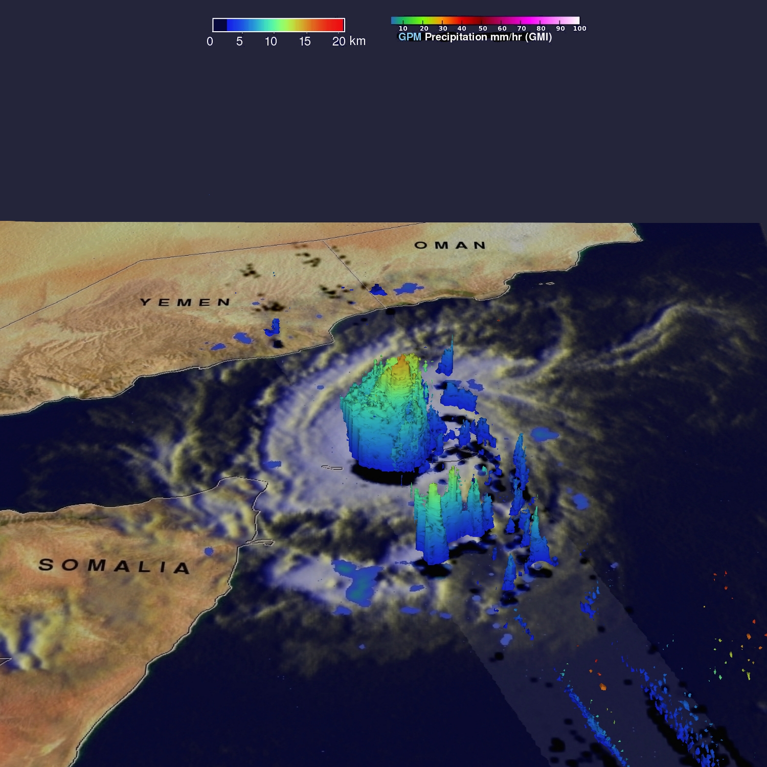
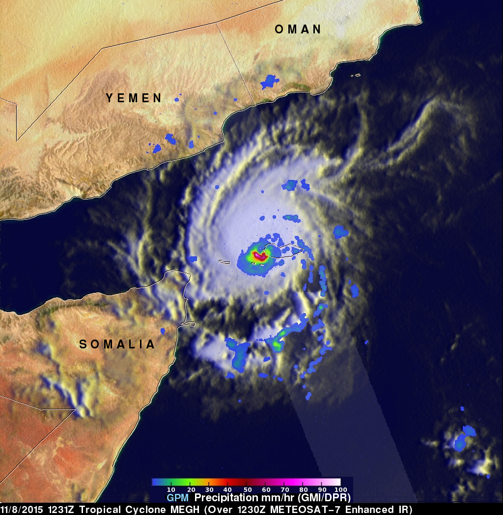
GPM captured this image of Megh Sunday November 8th at 12:31 UTC (7:31 am EST) just after the center had passed over Socotra. The image shows rain rates derived from the GPM GMI (outer swath) and DPR (inner swath) overlaid on enhanced IR data from the METEOSAT-7 satellite. The image reveals that Megh's rain field is rather small (Chapala's was much bigger) with most of the rain occurring in the southern half of the storm and not too far from the center. However, there are very intense rain rates of up to 100 mm/hr (~4 inches/hr shown in white) in the southern half of the eye wall surrounding the storm's center. These rain rates are associated with an area of deep convection evident in this coincident image, which shows a 3D rendering of Megh constructed from the DPR. At the time of these two images, Megh's maximum sustained winds were estimated at 100 knots (~115 mph) by JTWC, making it a Category 3 cyclone. After passing over Socotra, Megh continued to weaken as it continued westward before making landfall as a tropical storm on the southern coast of Yemen.
Click here to see a 1280x720 (Quicktime) rainfall accumulation animation.
Click here to see a 1280x720 (MPEG) rainfall accumulation animation.
Click here to see a (8 November 2015 1231Z) 1280x720 (Quicktime) flyby animation courtesy of GPM's Radar.
Click here to see a (8 November 2015 1231Z) 1280x720 (MPEG)flyby animation courtesy of GPM's Radar.