
Matthew Brings Heavy Rains, Destruction to Parts of the Northern Caribbean
Matthew began as a fairly impressive tropical wave that emerged off of the coast of Africa on the 23rd of September but had to make its way all the way across the Central Atlantic before finally organizing into a tropical storm on the morning of the 28th while passing through the Windward Islands. Matthew then slowly but steadily intensified into a minimal hurricane by the early afternoon of the following day as it continued to track westward through the central eastern Caribbean. The next day, September 30th, Matthew underwent a period of rapid intensification; its winds increased in intensity from 85 knots (~98 mph) to 140 knots (~161 mph) in the span of just 15 hours, taking the storm from a Category 2 to a Category 5 hurricane. Matthew was only at Category 5 intensity briefly, dipping back down to a still powerful Category 4 storm, which it maintained over the coming the 3 days. On Sunday, October 2nd, while over the central Caribbean, Matthew made a turn to the north between a weak trough of lower pressure over the Gulf of Mexico and a ridge of higher pressure to its east. This put the storm on a direct course for southwest Haiti, the eastern tip of Cuba and the lower Bahamas. Matthew stuck the southwest coast of Haiti around 7 am EDT as a powerful Category 4 hurricane near Les Anglais on the morning of Tuesday October 4th with maximum sustained winds reported at
145 mph by the National Hurricane Center. Matthew then continued moving northward before striking the eastern tip of Cuba in the evening later that same day before starting to veer off towards the northwest towards the Central Bahamas as a slightly weaker Category 3 storm.
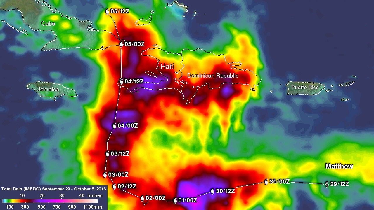
NASA's Integrated Multi-satellitE Retrievals for GPM or IMERG product is used to make estimates of precipitation from a combination of space-borne passive microwave sensors, including the GMI microwave sensor onboard the GPM satellite, and geostationary IR (infrared) data. This image shows IMERG rainfall estimates for the period 29 September to 5 October 2016 for the northeastern Caribbean in association with the passage of Hurricane Matthew, which is indicated by the white line and corresponding storm symbols. Beginning at 00 UTC on the 30th of September, rainfall totals associated with Matthew are in excess of 10 inches all along its track (shown in red), reaching upwards of 25 inches (shown in pink) when the storm was intensifying on the 30th. Over land, IMERGE shows wide areas of between 15 to 20 inches of rain (dark red and purple areas, respectively) all along the southern coasts of Haiti and the Dominican Republic on the island of Hispaniola. Rainfall amounts on the right side of Matthew are higher where the storm's counter-clockwise cyclonic circulation interacted with the island's topography. A separate but nearby cluster of thunderstorms on the eastern side of Matthew also contributed to the rainfall totals there. Haiti was hit hard by the storm. Though damage estimates are still coming in, so far a major bridge connecting Port-au-Prince with the southern part of country has been swept away by flooding and 108 fatalities have been reported there as a result of the storm. That number is expected to rise. In the neighboring Dominican Republic, 4 persons are reported to have died.
Currently, all eyes along the US East Coast are on Matthew. With warm waters and a favorable environment, the National Hurricane Center is forecasting Matthew, which has since regained some of its strength, to remain a powerful Category 4 storm as it approaches the east coast of Florida, forcing a massive evacuation from Florida to South Carolina.
GPM is a joint mission between NASA and the Japanese space agency JAXA.
Maximum rainfall totals for the real-time IMERG product have been adjusted to reflect observed values.