
IMERG Measures West Virginia's Deadly Flooding Rainfall
Since last Thursday over two dozen people have been reported killed and hundreds of homes have been destroyed by flooding in West Virginia. The governor of the state declared a federal disaster after the worst flooding in a century. The prevalence of rough terrain in West Virginia has amplified the effects of flooding rainfall. The National Weather Service predicted that thunderstorms were going to fall in the area again today. More flash flooding with streams again coming out of their banks has been predicted.
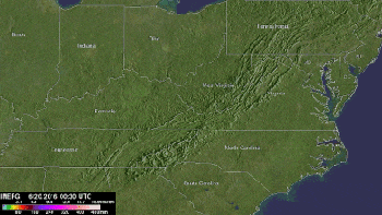
NASA's Integrated Multi-satellitE Retrievals for GPM (IMERG) data were used in this analysis to estimate rainfall that fell over West Virginia during the period from June 20-26, 2016. This IMERG analysis shows that extreme rainfall occasionally occurred during this period in an area extending from Illinois through North Carolina. Large areas from Illinois and Indiana through West Virginia were estimated to have received rainfall totals of 320 mm (12.6 inches).