Browse Remote Sensing Resources
Browse Remote Sensing Resources

Primary Topic:
Subtopics:
Type:
Keywords:
Standards:
Summary:
This website explores the technologies used to study and understand tropical cyclones.

Primary Topic:
Subtopics:
Type:
Keywords:
Summary:
This diagram illustrates the differences between active and passive remote sensing. TRMM and GPM rely on active and passive instruments to measure the properties of precipitation from space.

Primary Topic:
Subtopics:
Type:
Keywords:
Summary:
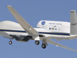
During the 2010 hurricane season, NASA deployed its piloted DC-8 and WB-57, and unmanned Global Hawk aircraft, arming hurricane researchers with the information needed to predict the growth and intensification of hurricanes.
Primary Topic:
Subtopics:
Type:
Keywords:
Summary:
NASA will dispatch two unmanned aircraft equipped with specialized instruments high above tropical cyclones in the Atlantic Ocean basin. These "severe storm sentinels" will investigate the processes that underlie hurricane formation and intensity change.

Primary Topic:
Subtopics:
Type:
Keywords:
Summary:
View recent data for air temperature, carbon dioxide, carbon monoxide, sea level, ozone, ice and water using an interactive viewer. You can also follow NASA's satellites and learn how they collect critical data about Earth's atmosphere, land, and oceans.

Primary Topic:
Subtopics:
Type:
Keywords:
Standards:
Summary:
An educational outreach program allowing middle school students to take pictures of our Earth from a digital camera on board the International Space Station. Educators must register in order to participate in EarthKAM missions and request photos of Earth.

Primary Topic:
Subtopics:
Type:
Standards:
Keywords:
Summary:
Animation that demonstrates the global coverage of the GPM Constellation of satellites.

Primary Topic:
Subtopics:
Type:
Standards:
Keywords:
Summary:
Engineers from the Japan Aerospace Exploration Agency (JAXA) and NASA Goddard Space Flight Center in Greenbelt, Md. oversee the arrival and unpacking of the dual-frequency Precipitation Radar.