Browse Remote Sensing Resources
Browse Remote Sensing Resources

Primary Topic:
Subtopics:
Type:
Keywords:
Summary:
This video celebrates the 15th anniversary of the Tropical Rainfall Measuring Mission (TRMM). Project Scientist Scott Braun looks back at TRMM's legacy and a few of the major scientific milestones the satellite has helped achieved.

Primary Topic:
Subtopics:
Type:
Keywords:
Summary:
Welcome to the Tour of the Electromagnetic Spectrum. This unique NASA resource on the web, in print, and with companion videos introduces electromagnetic waves, their behaviors, and how scientists visualize these data.
Primary Topic:
Subtopics:
Type:
Keywords:
Summary:
The activities in this guide will help students understand variations in environmental parameters by examining connections among different phenomena measured on local, regional and global scales.
Primary Topic:
Subtopics:
Type:
Standards:
Keywords:
Summary:
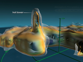
'Towers in the Tempest' is a 4.5 minute narrated animation that explains recent scientific insights into how hurricanes intensify. This intensification can be caused by a phenomenon called a 'hot tower'.

Primary Topic:
Subtopics:
Type:
Standards:
Keywords:
Summary:
The animations in this group show the long-term average sea surface temperature, the long term average sea surface salinity, and the the long term average sea surface density.

Primary Topic:
Subtopics:
Type:
Keywords:
Summary:
This animation of global precipitation from the Global Precipitation Climatology Project (GPCP) cycles through climatology data for each month of the year and then repeats the cycle twice.

Primary Topic:
Subtopics:
Type:
Keywords:
Summary:
Ocean circulation plays a key role in distributing solar energy and maintaining climate, by moving heat from Earth's equator to the poles. Aquarius salinity data, combined with data from other sensors, will give us a clearer picture of how the ocean works

Primary Topic:
Subtopics:
Type:
Keywords:
Summary:
Learn how scientists use a satellite called CERES to study the clouds and monitor Earth's climate changes.

Primary Topic:
Subtopics:
Type:
Keywords:
Summary:
Part 3 of a 4 part webquest that teaches the basics of precipitation science and technology. Prepares students for the GPM Anime Contest.

Primary Topic:
Subtopics:
Type:
Keywords:
Summary:
This classroom activity (originally developed for the GPM Poster) will teach students about the value of Earth's freshwater resources and how important it is to study how water is transferred and stored.