Search
Primary tabs
Search
Your search for "temperature" gave back 37 results.

Primary Topic:
Subtopics:
Type:
Standards:
Keywords:
Summary:
Students will compare temperature and precipitation graphs for various U.S. locations to look for patterns in geographical influence on climate, then collect data for a location of their choice and create their own climatogram.

Primary Topic:
Subtopics:
Type:
Keywords:
Summary:
This animation uses Earth science data from a variety of sensors on NASA Earth observing satellites as well as cartoons to describe Earth's water cycle and the continuous movement of water on, above and below the surface of the Earth.
Primary Topic:
Subtopics:
Type:
Standards:
Keywords:
Summary:
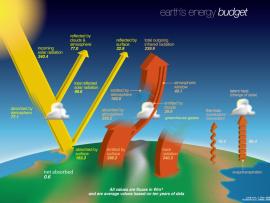
In this lesson, students will explore (through labs, videos, and a simulation) how energy from the sun is absorbed, reflected and radiated back out into space as part of the Earth’s energy budget.

Primary Topic:
Subtopics:
Type:
Keywords:
Summary:
View the latest data on the vital signs of the planet, including arctic sea ice levels, carbon dioxide, sea levels, global temperature and land ice.

Primary Topic:
Type:
Audience:
Keywords:
Summary:
This lesson is primarily for elementary school teachers who are looking for a hands-on inquiry based activity to teach their students about evaporation.

Primary Topic:
Subtopics:
Type:
Summary:
This lesson helps students learn about the geosphere by making observations and collecting data.

Primary Topic:
Subtopics:
Type:
Keywords:
Summary:
The cryosphere consists of those parts of the Earth's surface where water is found in solid form, including areas of snow, sea ice, glaciers, permafrost, ice sheets, and icebergs. This animation shows fluctuations in the cryosphere.

Primary Topic:
Subtopics:
Type:
Keywords:
Summary:
This lesson helps students learn about the atmosphere by making observations and taking measurements.

Primary Topic:
Subtopics:
Type:
Standards:
Keywords:
Summary:
Students will learn about measuring precipitation on the ground and using satellites, and use satellite data to analyze the reason for the monsoon weather pattern in India.

Primary Topic:
Subtopics:
Type:
Keywords:
Summary:
This NASA video segment focuses on how scientists use satellites to collect data. These sets of data are then analyzed and used to predict storms.