Search
Primary tabs
Search
Your search for "precipitation" gave back 161 results.

Primary Topic:
Subtopics:
Type:
Standards:
Keywords:
Summary:
This curriculum for 5th grade was designed to help students measure basic snow properties through science techniques, and focus on the connection between snowfall in the Sierra Nevada and water availability in the rest of California ...
Primary Topic:
Subtopics:
Type:
Standards:
Keywords:
Summary:
In this lesson, students will learn about the water cycle. The lesson is intended to be use by teachers before they take their students to view the Science On a Sphere movie, “Water Falls.”

Primary Topic:
Subtopics:
Type:
Keywords:
Summary:
The second spinoff video for the Science on a Sphere film "Water Falls." This video looks at the uses and advantages of remote sensing.

Primary Topic:
Subtopics:
Type:
Standards:
Keywords:
Summary:
This Speaker ToolKit has been designed to allow presenters (scientists, engineers, etc.) to easily present to an elementary and/or middle school audience about the water cycle.
Primary Topic:
Subtopics:
Type:
Summary:
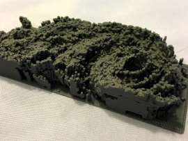
Requires access to a 3D printer. Learn how to use our 3D printed GPM data to teach about the structure of storms.

Primary Topic:
Type:
Audience:
Standards:
Keywords:
Summary:
This animation shows one molecule of water completing the hydrologic cycle.
Primary Topic:
Type:
Standards:
Keywords:
Summary:
This article teaches how a drop of rain changes shape as it falls through the atmosphere.

Primary Topic:
Subtopics:
Type:
Keywords:
Summary:
This website describes a study that is being conducted to understand the complexities of rainfall patterns and their effects on food security and human mobility.

Primary Topic:
Subtopics:
Type:
Standards:
Keywords:
Summary:
This flash animation takes viewers through four aspects of the water cycle: rain, water storage, vapor, and clouds.

Primary Topic:
Subtopics:
Type:
Keywords:
Summary:
Students then collect and analyze data about the size and shapes of raindrops. Students have the opportunity to compare a 2-D representation to a 3-D representation to understand why scientists use multiple sources of data to study Earth Systems.