Search
Primary tabs
Search
Your search for "flood" gave back 12 results.
Primary Topic:
Subtopics:
Type:
Standards:
Summary:
This web eBook, developed in collaboration with the World Bank Group, explores water on Earth and how NASA observes and measures it.

Primary Topic:
Subtopics:
Type:
Keywords:
Summary:
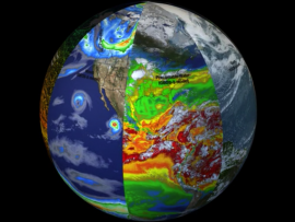
Researchers need accurate and timely rainfall information to better understand and model where and when severe floods, frequent landslides and devastating droughts may occur, and GPM’s global rainfall data will help provide that information.

Primary Topic:
Type:
Summary:
Coming soon - "Raindrop Tales: GPM Meets Mizu-chan" - an educational comic based on the winning characters from our GPM Anime Challenge.

Primary Topic:
Subtopics:
Type:
Keywords:
Summary:
This is an introductory lesson to acquaint middle school students to many aspects of a serious and common natural disaster; flooding. Students will be directed to visit websites where they will interact with various types of media.

Primary Topic:
Subtopics:
Type:
Standards:
Keywords:
Summary:
In this promotional video NASA scientists discuss why it is so important to study and track Earth's freshwater resources, and explain the purpose of the Global Precipitation Measurement mission.
Primary Topic:
Type:
Summary:
The Olympic Mountain Experiment, or OLYMPEX, is a NASA-led field campaign, which will take place on the Olympic Peninsula of Washington State from November 2015 through February 2016.
Primary Topic:
Subtopics:
Type:
Keywords:
Summary:
Faisal Hossain, a civil and environmental engineering professor at Tennessee Technological University, uses NASA satellite data to help Bangladeshi authorities monitor their water resources and prepare for water-related disasters.

Primary Topic:
Subtopics:
Type:
Standards:
Keywords:
Summary:
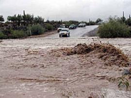
Heavy spring rains and snowmelt led to devastating floods along the Mississippi River in May 2011. Landsat 5 flew over the Mississippi River on May 10, 2011, giving a distinct view of the extraordinary extent of the flooding.
Primary Topic:
Subtopics:
Type:
Keywords:
Summary:
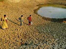
Humans need freshwater for many purposes, but it's not evenly distributed across our planet, which can create challenges for many communities.
Primary Topic:
Subtopics:
Type:
Standards:
Keywords:
Summary:
The short video, 'For Good Measure' explains why scientists turn to satellites to get a worldwide view of rainfall.