Browse Resources
Browse Resources
Primary Topic:
Subtopics:
Type:
Standards:
Keywords:
Summary:
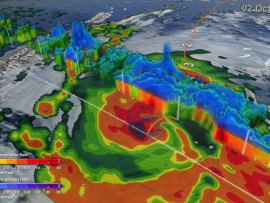
NASA researchers use a combination of satellite observations to re-create multi-dimensional pictures of hurricanes and other major storms in order to study complex atmospheric interactions. In this video, they applied those techniques to Hurricane Matthew
Primary Topic:
Subtopics:
Type:
Standards:
Keywords:
Summary:
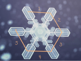
GPM Project Scientist Gail Skofronick-Jackson explains why all snowflakes have six sides and how the Global Precipitation Measurement Mission can measure falling snow from space.
Primary Topic:
Subtopics:
Type:
Keywords:
Summary:
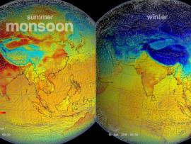
The monsoon is a seasonal rain and wind pattern that occurs over South Asia (among other places). Through NASA satellites and models we can see the monsoon patterns like never before.

Primary Topic:
Subtopics:
Type:
Standards:
Keywords:
Summary:
This video explains why the size and shape of raindrops in a cloud matters to scientists, and how the Global Precipitation Measurement Mission is able to provide these measurements from space.

Primary Topic:
Subtopics:
Type:
Keywords:
Summary:
In this program, GPM mission scientists and education specialists talk about watersheds and related educational resources.

Primary Topic:
Subtopics:
Type:
Keywords:
Summary:
This web seminar provided a robust understanding on the science behind Earth’s water cycle, while also demonstrating multiple possibilities for infusing water-related concepts into the curriculum.

Primary Topic:
Subtopics:
Type:
Keywords:
Summary:
This short animation from the Community Collaborative Rain Hail and Snow Network shows how decision makers use a variety of data and in-person reports to assess the drought conditions across the United States.

Primary Topic:
Subtopics:
Type:
Keywords:
Summary:
The second spinoff video for the Science on a Sphere film "Water Falls." This video looks at the uses and advantages of remote sensing.
Primary Topic:
Subtopics:
Type:
Summary:
GPM Application Science Lead, Dr. Dalia Kirschbaum, explains how GPM observes snow, and the importance of understanding snow characteristics and distribution in a changing climate.

Primary Topic:
Subtopics:
Type:
Keywords:
Summary:
GPM Application Science Lead, Dr. Dalia Kirschbaum, explains how landslides and floods occur, and how satellite imagery is used in understanding these disasters.