Washi

Philippines Devastated by Tropical Storm Washi

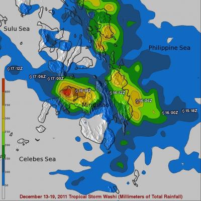
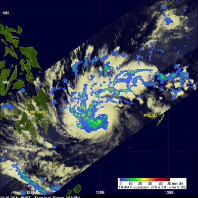
Washi, known locally in the Philippines as Sendong, began as a tropical depression on the 13th of December 2011 in the West Pacific Ocean about 2150 km (~1333 miles) due east of the southern Philippines. Washi only intensified slightly and never exceeded tropical storm intensity as it tracked due west towards the southern Philippines' island of Mindanao. Washi made landfall on the east coast of Mindanao on the afternoon of the 16th as a moderate tropical storm with sustained winds reported at 55 knots (~63 mph). Despite its modest intensity, Washi had a huge impact on the island. As Washi made

Tropical Storm Washi (27W) Strengthens

As expected tropical storm Washi (27W) had strengthened when the TRMM satellite passed over on 15 December 2011 at 1515 UTC collecting data used in the rainfall analysis shown above. TRMM Microwave Imager (TMI) and Precipitation Radar (PR) data are shown overlaid on an enhanced infrared image from the satellite's Visible and InfraRed Scanner (VIRS). This rainfall analysis shows that Washi was much better organized with very heavy rainfall of over 50mm/hr (~2 inches) revealed by TRMM PR within bands spiraling into the center of the storm. The 3-D image above used Precipitation Radar data from

Tropical Storm 27W Forming

Tropical Cyclones can form in the western Pacific Ocean at any time during the year but they occur most frequently during the months of June through November so tropical storm 27W is a little unusual. The TRMM satellite saw what was then tropical depression 27W on 13 December 2011 at 1533 UTC. It was upgraded to a Tropical storm by the Joint Typhoon Warning Center (JTWC) the next day at 0900 UTC. TRMM's Microwave Imager (TMI) shows that moderate rainfall was located in clusters of strong convective storms within the developing tropical cyclone. Tropical storm 27W has been predicted to