US East Coast

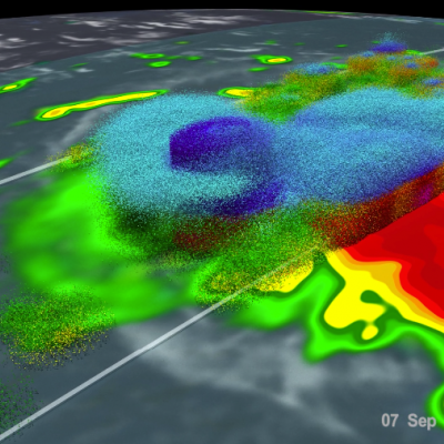
Hurricane Florence Makes Landfall, Brings Torrential Rains and Record Flooding to the Carolinas

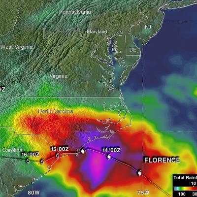
Over the weekend #HurricaneFlorence brought torrential rains and record flooding to the Carolinas. This GPM IMERG visualization shows storm-total accumulated rainfall on the left for 9/12/18 - 9/17/18 vs. a sequence of 3-hour accumulations on the right https://t.co/numzHJXzb2 pic.twitter.com/pzAgkVrRXl — NASA Precipitation (@NASARain) September 17, 2018 After making its way across the Atlantic, Florence, a once powerful Category 4 hurricane with maximum sustained winds reported at 140 mph by the National Hurricane Center (NHC), finally made landfall early Friday morning at around 7:15 am EDT
GPM Flies Over Tropical Cyclone Florence
Download in High Resolution from the NASA Goddard Scientific Visualization Studio GPM passed over Tropical Storm Florence on September 7, 2018. As the camera moves in on the storm, DPR's volumetric view of the storm is revealed. A slicing plane moves across the volume to display precipitation rates throughout the storm. Shades of green to red represent liquid precipitation. Frozen precipitation is shown in cyan and purple. NASA's Global Precipitation Measurement mission or GPM core observatory satellite flew over Tropical Storm Florence on September 7, 2018. At that time, the storm was...

GPM IMERG Adds Up Heavy Rainfall Over the U.S. East Coast

A stalled weather pattern led to persistent showers and thunderstorms moving up the eastern seaboard last week, resulting in significant rainfall amounts and numerous flood warnings. A nearly stationary elongated upper-level trough of low pressure stretching down from the Great Lakes to Florida combined with a persistent Bermuda High off the coast to channel a steady flow of warm, humid air up the eastern seaboard. The result was a week of re-occurring showers and thunderstorms across the region. The Integrated Multi-satellitE Retrievals for GPM or IMERG is used to estimate precipitation from

GPM Sees Fourth Nor'easter of 2018

More than 90,000 customers were without power overnight after another major nor’easter — the fourth in three weeks — pummeled areas of the U.S. east coast with as much as 19 inches of snow on the first full day of spring. GPM collected this precipitation data as it flew over the storm the evening of Wednesday March 21st, 2018 at 6:04pm ET.

GPM Views Snow in Third Nor'easter of 2018

The GPM Core Observatory satellite flew over a powerful winter storm early on the morning of Tuesday March 13th, 2018, the third such "Nor'easter" to hit the U.S. east coast this year. GPM's Dual-frequency Precipitation Radar took 3D measurements as it flew over the storm, which show the boundary between liquid (green / yellow / red) and frozen (blue) precipitation. The storm is expected to last through most of Tuesday, disrupting road and air travel. Image and caption by Jacob Reed (Telophase / NASA GSFC
GPM Sees Powerful Winter Storm Grayson
Powerful Coastal Storm Brings Snow, Extreme Cold, Wind and Blizzard Conditions to the East Coast View an interactive 3D visualization of GPM data from Winter Storm Grayson in STORM Event Viewer Mobile version Cold Artic air has been keeping the vast majority of the country east of the Rockies in the deep freeze over the past week. Now a powerful coastal storm is working its way up the East Coast bringing a mixture of snow, freezing rain, high winds and blizzard conditions from as far south as Florida all the way up into Maine with blizzard warnings in effect along the coast from North Carolina...

Powerful Northeastern Storm Examined By GPM Satellite

The GPM satellite showed the distribution and intensity of precipitation on the eastern side of the low pressure center. The approximate location of the storm's center at the time of the GPM pass is shown with a large red "L". GPM's Microwave Imager (GMI) showed that a large area of intense rain was located in the Atlantic east of the low's center. GMI estimated that rain in that area was falling at rates of greater than 2 inches (51 mm) per hour. GPM's Precipitation Radar (DPR) instrument showed that the low was dropping rain at a rate of over 4.92 inches (125 mm) per hour in a small area

Jose Continues to Meander off the East Coast

Jose has been a named storm for nearly two weeks now as it continues to slowly move northward off the US East Coast east of the Outer Banks of North Carolina. At one time, Jose was a powerful category 4 border line category 5 storm with maximum sustained winds reported at 155 mph by the National Hurricane Center back on the 9th of September as it was approaching the northern Leeward Islands. Jose passed northeast of the Leeward Islands as a category 4 storm on a northwest track and then began to weaken due to the effects of northerly wind shear. Jose then made a counterclockwise loop about

Deadly Hurricane Matthew's Total Rainfall

Hurricane Matthew devastated western Haiti and killed over 1,000 people. Matthew also took the lives of at least 37 deaths in the United States with 18 deaths occurring in the state of North Carolina. Flooding is still widespread in North Carolina. Some rivers in North Carolina such as the Tar and the Neuse are still rising. This rainfall analysis was accomplished using data from NASA's Integrated Multi-satelliE Retrievals for GPM (IMERG). IMERG is a unified U.S. algorithm that provides a multi-satellite precipitation product. IMERG is run twice in near-real time with the “Early” multi

GPM Takes Parting Look At Hermine

Post Tropical Cyclone Hermine was still rotating in the Atlantic Ocean east of New Jersey when the the GPM core observatory satellite flew above on September 6, 2016 at 2:05 PM EDT ( 1806 UTC). Hermine's power was greatly dissipated from the hurricane that hit Florida on September 2, 2016. Hermine still had maximum sustained winds of about 58 mph (50 kts). Hermine was also still producing some light to moderate showers. Precipitation data shown here were derived from GPM's Microwave Imager (GMI) and Dual-Frequency Precipitation Radar (DPR) instruments. Those data showed that rain was falling