Typhoons

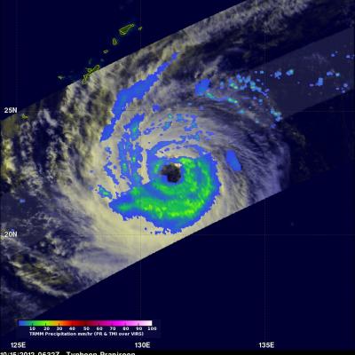
Typhoon Usagi Still Powerful

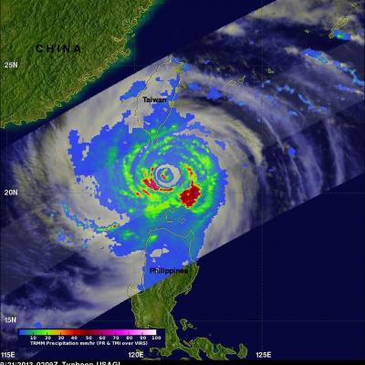
The TRMM satellite again flew directly above category two typhoon USAGI, with maximum wind speeds of about 120kts (~130mph), on September 21, 2013 at 0209 UTC as USAGI was passing between Taiwan and the Philippines. Rainfall data from TRMM's Microwave Imager (TMI) and Precipitation Radar (PR) instruments are shown in this image. TRMM PR found rain falling at a rate of over 134 mm/hr (~5.2 inches) in USAGI's eye wall where radar reflectivity values of over 51dBZ were returned to the satellite. A weaker Typhoon USAGI is predicted to hit Hong Kong tomorrow with wind speeds of 80kts (~92 mph).

TRMM Sees Powerful Typhoon Utor As It Neared China

Torrential rain and powerful winds accompanied typhoon Utor when it came ashore in southern China's Guangdong province. The TRMM satellite flew above as typhoon Utor was headed toward southern China on August 13, 2013 at 2156 UTC. At the time of this TRMM pass typhoon Utor was a powerful typhoon with wind speeds reaching over 85kts (~98mph). A rainfall analysis from TRMM's Microwave Imager (TMI) and Precipitation Radar (PR) instruments is shown overlaid on an infrared image from TRMM's Visible and InfraRed Scanner (VIRS). Bands of intense rainfall are shown spiraling into the eye that was

Typhoon UTOR Hits The Philippines

A category four typhoon called UTOR hit the Philippines with wind speeds of about 120kts (~138 mph). It has been reported that at least one person was killed and 20 fishermen are missing. Landslides are also likely due to heavy rainfall that is occurring over the Philippine's rugged mountainous terrain. The image above used data collected by the TRMM satellite when it passed over UTOR on August 12, 2013 at 0621 UTC as it was exiting the Philippines into the South China Sea. TRMM's Microwave Imager (TMI) and Precipitation Radar (PR) data are shown overlaid on a combination Infrared/Visible

Typhoon Bopha's Heavy Rain Over Mindanao

High winds, flooding and landslides from heavy rains with typhoon Bopha have caused over 300 deaths in the southern Philippines. The Tropical Rainfall Measuring Mission (TRMM) satellite's primary mission is the of measurement of rainfall in the Tropics. The TRMM-based, near-real time Multi-satellite Precipitation Analysis (MPA) at the NASA Goddard Space Flight Center monitors rainfall over the global Tropics. MPA rainfall totals are shown here for the period from November 28 to December 5, 2012 when typhoon Bopha was moving through the southern Philippines. Typhoon Bopha's track is shown

Typhoon Bopha Devastates Mindanao, Moves Into Sulu Sea

Typhoon Bopha pounded the Philippines with high winds and drenching rain when it crossed the island of Mindanao today. Numerous deaths and wide spread destruction have been reported. The TRMM satellite had a good view of Bopha moving into the Sulu Sea when it flew over on December 4, 2012 at 1420 UTC. This TRMM pass showed that Bopha still had good organization but Mindanao's rugged terrain had taken it's toll. Bopha's eye had been disrupted but TRMM Precipitation Radar (PR) data revealed that very heavy rain was still falling at a rate of over 85 mm/hr (~3.5 inches) near the center of the

Typhoon Bopha Threatens Philippines

At 0347 UTC today the TRMM satellite flew above a dangerous typhoon in the western Pacific Ocean called Bopha that is a threat to the Philippines. Bopha is predicted by the Joint Typhoon Warning Center (JTWC) to hit the island of Mindinao in the Philippines with winds of 135 kts (155 mph) later today. The first image shows a satellite view of typhoon Bofa with rainfall from TRMM's Microwave Imager (TMI) and Precipitation Radar (PR) instruments overlaid on a visible/infrared image from TRMM's Visible and InfraRed Scanner (VIRS). This analysis shows that Bopha had a well defined eye with very

Typhoon Jewalat Batters Japan

The TRMM satellite had an excellent look at typhoon Jelawat on September 29, 2012 at 1944 UTC. Jelawat had already battered Okinawa with 75kt (~87mph) winds and was headed for the main islands of Japan. An analysis of rainfall from TRMM's Microwave Imager (TMI) and Precipitation Radar (PR) instruments is shown overlaid on an enhanced infrared image from TRMM's Visible and InfraRed Scanner (VIRS). Rain is shown falling at a rate of over 90mm/hr (~3.5 inches) in strong feeder bands northwest of Jelawat's center of circulation. Jelawat was already causing light to moderate rainfall on the

Weakening Typhoon Prapiroon

The TRMM satellite again flew above typhoon Prapiroon in the western Pacific Ocean on October 15, 2012 at 0632 UTC. Prapiroon's sustained wind speeds had dropped to 70 kts (~81 mph) with a large and ragged eye being it's dominant feature. TRMM's Microwave Imager (TMI) data indicated that the most intense rain bands south of Prapiroon's eye were dropping rain at a rate of about 30-40 mm/hr (~1.2 to 1.6 inches).

TRMM Sees Prapiroon Near Japan

The TRMM satellite recently had good views of tropical storm Prapiroon when it was passing east of Japan. The TRMM satellite captured data on October 18, 2012 at 0845UTC and again at 1019 UTC. TRMM's Microwave Imager (TMI) and Precipitation Radar (PR) data show that rain associated with Prapiroon was falling at a rate of over 75mm/hr (~3 inches) in a feeder band northwest of the center of circulation. TRMM PR found radar reflectivity values above 50.770 dBz in that area. Some of the rainfall over Japan was being caused by a frontal system that was interacting with tropical storm Prapiroon
Map of tracking hurricane Irene
This page will redirect you to the "GPM: Hurricanes Beyond the Tropics" video. Click here if you are not redirected.