Typhoons

Super Typhoon Rammasun Strikes the Southern Coast of China

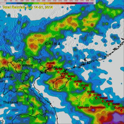
Super typhoon Rammasun struck the southern coast of China on Friday July 18th as a very powerful super typhoon with sustained winds estimated at 135 knots (~155 mph or equivalent to a Category 5 hurricane on the US Saffir-Simpson scale), making it the strongest typhoon to hit the area in several decades. Rammasun made landfall at 3:30 pm (local time) on Hainan Island where the southern half of the intense eye wall raked across the northeast tip of that island. The center then quickly cut across the Qiongzhou Strait separating Hainan from the Leizhou Peninsula to the north. The right half of
Deadly Typhoon Rammasun Crosses The Phillipines JacobAdmin Wed, 07/16/2014
Typhoon Rammasun known locally as "Glenda" is the most powerful typhoon to hit the Philippines this year. As of today, Ten deaths have been attributed to Rammasun. Flooding and landslides are expected due to heavy rainfall. Typhoon Rammasun's track was north of Super Typhoon Haiyan's path of destruction through the Philippines in November 2013. The image above is a preliminary analysis of rainfall during the period when typhoon Rammasun was moving over the Philippines. Typhoon Rammasun's track is shown in red. This analysis is the result of a TRMM-calibrated merged global Multi-satellite
Typhoon Rammasun Strikes The Philippines JacobAdmin Tue, 07/15/2014
Today typhoon Rammasun is pounding the Philippines with strong winds and heavy rainfall. Rammasun was labeled a tropical storm on July 12, 2014 when it formed west of Guam. Rammasun strengthened and was upgraded to a typhoon on July 14, 2014. Typhoon Rammasun became still more powerful and had winds estimated at 100kts (about 115 mph) today making it a category three tropical cyclone on the Saffir-Simpson hurricane wind scale. The images above show typhoon Rammasun as the TRMM satellite flew over on July 14, 2014 at 1819 UTC and again on July 15, 2014 at 0410 UTC. These images show that
Tropical Storm Neoguri Soaks Southern Japan JacobAdmin Thu, 07/10/2014
Once powerful typhoon Neoguri is dropping copious rainfall as it passes over southern Japan as a tropical storm. Heavy rainfall from Neoguri fell on land that was already soaked earlier this month by a slow moving seasonal frontal system. Flooding and mudslides from Neoguri have caused the deaths of three people in Japan this week. The TRMM Multi-Satellite Precipitation Analysis (TMPA), produced at Goddard Space Flight Center, combines the rainfall estimates generated by TRMM and other satellites (3B42). The analysis above shows a near-real time Multi-satellite Precipitation Analysis (TMPA)

Deadly Philippine Flooding And Landslides

People in the southern Philippines are used to heavy rainfall this time of the year but rainfall totals have recently been exceptionally high. A tropical low northeast of Mindanao has been an almost permanent feature on weather maps for the past week. It has caused nearly continuous rain in the area of northeastern Mindanao triggering floods and landslides that have caused the reported deaths of 34 people. The TRMM Multi-Satellite Precipitation Analysis (TMPA), produced at Goddard Space Flight Center, combines the rainfall estimates generated by TRMM and other satellites (3B42) . The analysis

Haiyan and Tropical Storm 30 Bring Heavy Rains to the Philippines

Super typhoon Haiyan, known locally in the Philippines as Yulonda, will go down as a historic storm, making landfall in the central Philippines as perhaps the most powerful tropical cyclone to ever make landfall with sustained winds estimated at 195 mph (~315 kph). So far, over 2300 people are confirmed to have been killed by the storm, and the number is likely to climb higher with many still missing and not all areas unaccounted for. Katrina, which devasted the US Gulf coast in 2005, was responsible for 1833 fatalities The most deadly flooding from Super Typhoon Haiyan was caused by the storm
Super Typhoon Haiyan Hits the Philippines
Super typhoon Haiyan, equivalent to a Category 5 hurricane on the US Saffir-Simpson scale, struck the central Philippines municipality of Guiuan at the southern tip of the province of Eastern Samar early Friday morning at 20:45 UTC (4:45 am local time) as an extremely powerful super typhoon, perhaps the strongest ever recorded at landfall, with sustained winds estimated at 195 mph (315 kph) by the Joint Typhoon Warning Center. Previously, Hurricane Camille, which struck the northern Gulf Coast in 1969, held the record with 190 mph sustained winds at landfall. After striking Samar, Haiyan...

TRMM Has Second Look At Typhoon Krosa

On November 1, 2013 at 1320 UTC the TRMM satellite had the second look at typhoon KROSA. KROSA weakened slightly when it passed over the northern Philippines but had started to intensify with this second pass over the South China Sea. The image on the left shows rainfall data collected by TRMM's Microwave Imager (TMI) and Precipitation Radar (PR) instruments overlaid on an enhanced infrared image. TRMM PR data revealed that rain was falling at a rate of over 116mm/hr (4.5 inches) in KROSA's eye wall. Radar reflectivity values greater than 50dBZ were found in the same area. The 3-D perspective

Weaker Typhoon Francisco Seen By TRMM

Typhoon Francisco was headed toward the islands of southern Japan when the TRMM satellite had a good view on October 22, 2013 at 0933 UTC. Francisco was weakening and had estimated winds of less than 75kts (~86 mph) with this TRMM pass. An analysis derived from TRMM's Microwave Imager (TMI) and Precipitation Radar (PR) instruments is shown overlaid on an enhanced infrared image from TRMM's Visible and InfraRed Scanner (VIRS). This analysis showed that the most intense rain was falling at a rate of over 75mm/hr (~3 inches) in a location well to the southwest of Francisco's center of circulation

Deadly Typhoon Usagi Hits Southern China

The most powerful typhoon of 2013 hit southern China with reported winds of 95.6 kts (~110 mph) killing at least 20 people. The TRMM satellite had a fairly good view on September 22, 2013 at 0923 UTC as typhoon USAGI's eye was very near the coast of southern China. TRMM's Microwave Imager (TMI) and Precipitation Radar (PR) instruments showed that in addition to the extreme winds reported there were areas just south of USAGI's eye where rain was falling at a rate of over 169mm/hr (~6.7 inches). TRMM sliced through USAGI and found that heights of storms within USAGI were reaching only about 12km