tropical depressions

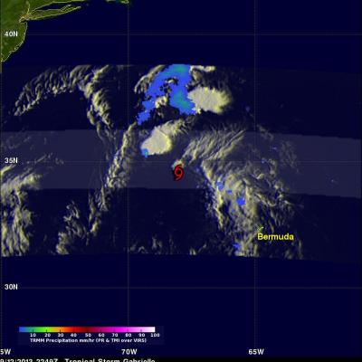
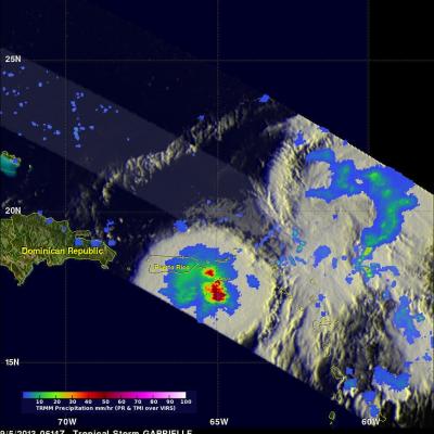
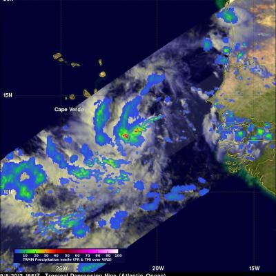
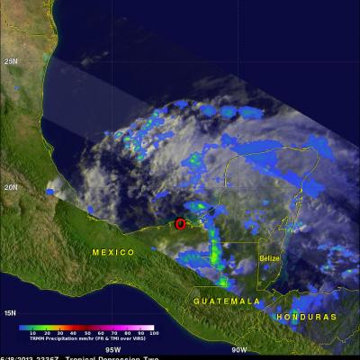
TD11 Upgraded To Tropical Storm Jerry

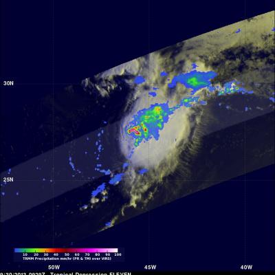
At 1500 UTC (11:00 AM EDT) the National Hurricane Center (NHC) upgraded TD11 to tropical storm Jerry. Tropical Depression ELEVEN (TD11) developed in the central Atlantic Ocean on Saturday September 28, 2013. Southwesterly wind shear reduced TD11's strengthening until this morning. TD11 was having strong bursts of convection when the TRMM satellite flew over earlier at 0929 UTC (~ 6:29 AM Local Time). The image on the left shows a rainfall analysis that uses TRMM Precipitation Radar (PR) data from that orbit. It shows that rain was falling at a rate of over 150 mm/hr from some powerful

Tropical Depression Gabrielle

Tropical Storm Gabrielle passed close to Bermuda on Wednesday and has now moved out of the TRMM satellite's coverage area (40N-40S). Tropical depression Gabrielle is currently moving over the open waters of the North-Atlantic toward Newfoundland and is predicted to be absorbed by a front tomorrow. A red tropical storm symbol shows the location of Gabrielle's nearly rain free center when TRMM passed above on Thursday September 12, 2013 at 2249 UTC (6:49 PM EDT).

Tropical Depression Gabrielle

The National Hurricane Center (NHC) upgraded a low pressure center south of Puerto Rico to tropical depression number seven on September 4, 2013 at 2100 UTC (5:00 PM EDT). The tropical depression was then again upgraded to tropical storm Gabrielle on September 5, 2013 at 0300 UTC (September 4, 2013 11 PM EDT). Gabrielle was subsequently downgraded today to a tropical depression at 1500 UTC (11 AM EDT). The TRMM satellite's Microwave Imager (TMI) had a fairly good look at tropical storm Gabrielle very early this morning at 0614 UTC (2:14 AM EDT). TRMM's TMI found rain falling at a rate of over

Tropical Depression Nine Forms Near Cape Verde Islands

As predicted by the National Hurricane Center (NHC) tropical depression Nine formed with a strong tropical wave that moved from the African coast to an area south of the Cape Verde Islands. The low pressure center was designated tropical depression Nine at 2100 UTC (5PM EDT). The TRMM satellite flew directly above the developing tropical depression earlier at 1651 UTC (12:51 PM EDT). This TRMM pass found rain falling at a rate of over 101mm/hr (~4 inches) near the center of the developing tropical depression. TRMM's PR instrument was used to show a 3-D view of TD9. Radar reflectivity values

Tropical Depression Gabrielle

The National Hurricane Center (NHC) upgraded a low pressure center south of Puerto Rico to tropical depression number seven on September 4, 2013 at 2100 UTC (5:00 PM EDT). The tropical depression was then again upgraded to tropical storm Gabrielle on September 5, 2013 at 0300 UTC (11 PM EDT). Gabrielle was subsequently downgraded to a tropical depression at 1500 UTC (11 AM EDT). The TRMM satellite's Microwave Imager (TMI) had a fairly good look at tropical storm Gabrielle very early this morning at 0614 UTC (2:14 AM EDT). TRMM's TMI found rain falling at a rate of over 56mm/hr (~2.2 inches) in

Intensifying TD02 Moves Into The Bay Of Campeche

The TRMM satellite passed above tropical depression two on June 18, 2013 at 2336 UTC (6:43 PM CDT). A red circle shows the approximate location of TD02 just before it entered the Bay Of Campeche in the the southern Gulf Of Mexico. Data from TRMM's Microwave Imager (TMI) and Precipitation Radar (PR) instruments showed that TD02 was still only producing light to moderate rainfall. The most intense rainfall over land, at about 28.7mm/hr (~1.1 inches), was found by TRMM's TMI in a line of storms extending from northwestern Guatemala into the Gulf Of Mexico. The National Hurricane Center (NHC)

TRMM Sees Tropical Depression Two

Tropical depression two that formed on Monday June 17, 2013 was observed by the TRMM satellite on June 18, 2013 at 0034 UTC (8:34 PM EDT). TRMM's Microwave Imager (TMI) and Precipitation Radar (PR) data showed that rainfall around TD02 was mainly light to moderate with TRMM PR finding that the heaviest rainfall of slightly over 69 mm/hr (2.7 inches) was located in Nicaragua.

Tropical Depression Beryl Drenches Florida And Georgia

At times Tropical storm beryl has been producing intense rainfall over the southeastern United States since coming ashore early on Monday May 28, 2012. The TRMM satellite had good views of Beryl's rainfall on Monday May 28, 2012 at 2033 UTC (4:33 PM EDT) and on Tuesday May 29, 2012 at 0127 UTC (Monday May, 28 2012 at 9:27 PM EDT). Data from TRMM's Microwave Imager (TMI) and Precipitation Radar (PR) are shown in two images from those orbits. These TRMM images show that bands of rainfall rotating around Beryl were mainly affecting only northern Florida and southeastern Georgia. A few areas of

Tropical Depression Banyan

The TRMM satellite collected data on 14 October 2011 at 0837 UTC that were used to make the images above of tropical depression Banyan (known as Ramon in the Philippines). Tropical storm Banyan was the latest killer cyclone to hit the Philippines this year following closely on the heels of typhoons Nesat and Nalgae. Banyan resulted in the reported deaths of at least nine people in the Philippines before weakening and moving into the south china sea as a tropical depression. TRMM satellite data shows that Banyan, although small, contained some powerful convective storm near the center of the