tropical depressions

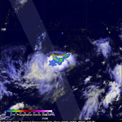
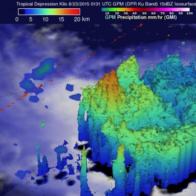
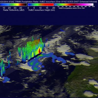
GPM Sees Tropical Depression Nine (td9) Forming

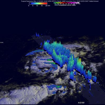
Tropical cyclone development has been relatively slow in the Atlantic Ocean in 2015 with tropical depression Nine (TD9) forming today in the central tropical Atlantic. GPM's Microwave Imager (GMI) and Dual-Frequency Precipitation Radar (DPR) instruments collected data today at 1016 UTC (6:16 AM EDT). Data from that pass were used to show the three dimensional (3-D) extent of TD9's rainfall. GPM's 3-D DPR (Ku Band) found that the tallest convective thunderstorms within TD9 were reaching heights of about 14.9 km (9.2 miles) in a feeder band southeast of TD9's center of circulation. The most

GPM Sees Energetic Tropical Depression Kilo

Rainfall associated with tropical depression Kilo recently dumped heavy rain in some areas of the state of Hawaii. Tropical depression Kilo changed course to move away from the Hawaiian Islands so it is no longer a threat but has recently been more energetic. The GPM core observatory satellite flew over on August 25, 2015 at 0121 UTC as Kilo approached Johnson Atoll and found that rainfall intensity had recently increased and the tropical depression's storm tops were very tall. GPM's Dual-Frequency Precipitation Radar (DPR) discovered that rain was falling at a rate of almost 65 mm (2.6 inches

Tropical Depression Kilo May Be A Problem For Hawaii

A tropical depression labeled Kilo formed to the southeast of the Hawaiian Islands on August 20, 2015. The tropical cyclone has moved to the southwest of the Islands. The Central Pacific Hurricane Center (CPHC) predicts that Kilo will strengthen into a hurricane as it moves in the general direction of the island of Kauai over the next five days. The GPM core observatory satellite measured the rainfall near Kilo on August 23, 2015 at 0131 UTC. GPM’s Microwave Imager (GMI) and GPM's Dual-Frequency Precipitation Radar (DPR) discovered that rain was falling at a rate of over 121 mm (4.8 inches)

TD08E Formation Monitored By GPM

The GPM core observatory satellite flew over forming tropical depression 08E on July 27, 2015 at 1931 UTC ( 12:31 PM PDT). Rainfall was measured by GPM's Microwave Imager (GMI) and Dual-Frequency Precipitation Radar (DPR) falling at a rate of 50 mm (almost 2 inches) per hour in storms near the center of the tropical depression. The National Hurricane Center (NHC) predicts that TD08E will not intensify very much because northwesterly vertical wind shear is retarding development. GPM's DPR instrument scan (shown in lighter shades) viewed an area east of the center of the developing tropical

Tropical Depression Five Forms

As typhoon Maysak heads toward the Philippines yet another tropical cyclone was born today in the the Pacific Ocean west of Pohnpei. The GPM core observatory satellite had a good view of tropical depression five on April 3, 2015 at 1031 UTC. GPM's Microwave Imager (GMI) found that rain was dropping at a rate of 22.4 mm (.9 inches) per hour in bands of convective storms located northwest of the center of circulation. The 3-D view from GPM's Dual-Frequency Precipitation Radar (Ku Band) shows that some of these storms were reaching heights of over 14.7 km (9.1 miles).
Tropical Depression Mekkhala Organizes JacobAdmin Wed, 01/14/2015
Tropical Depression 01W, in the western Pacific Ocean, has been given the name Mekkhala. The tropical cyclone has become much better organized and the Joint Typhoon Warning Center (JTWC) predicts that tropical storm Mekkhala will affect the eastern Philippines in a few days. The GPM (core satellite) flew above Mekkhala on January 14, 2015 at 1043 UTC. GPM's Microwave Imager (GMI) instrument observed rain falling at a rate of over 71.63 mm (about 2.8 inches) per hour in intense convective storms near the tropical cyclone's center. This 3-D view was derived from data collected by GPM's Radar (Ku

Two Satellites Measured Rainfall in Tropical Depression Mekkhala

The first tropical depression of the 2015 western Pacific season formed southwest of Guam on January 13 and is predicted to intensify into a tropical storm while headed toward the Philippines. NASA's TRMM and GPM satellites provided a look at Tropical Depression Mekkhala's rainfall data that showed the area of moderate rainfall had expanded as the storm strengthened on January 13. Mekkhala was previously known as Tropical Depression 01W until January 14 when it was renamed. Both the Global Precipitation Measurement (GPM) core satellite and the Tropical Rainfall Measuring Mission (TRMM)

Tropical Depression 18E Forms

Tropical cyclones have continued to form in the eastern Pacific Ocean at a faster rate than last year. This morning at 8 AM PDT (1500 UTC) a low pressure center south of Mexico was upgraded to a tropical depression (18E). The TRMM satellite crossed over the forming tropical depression on September 23, 2014 at 0729 UTC (00:20 AM PDT). TRMM's Precipitation Radar (PR) instrument found that rain was falling at a rate of almost 61 mm (2.4 inches) per hour near the low's center of circulation. Radar reflectivity values of over 51 dBZ were analyzed in some heavy showers by TRMM PR. This simulated 3-D

Tropical Depression Two-E Forms

As predicted, yesterday afternoon a low pressure center south of the Gulf of Tehuantepec was classified as tropical depression TWO-E by the National Hurricane Center (NHC). The TRMM satellite passed over the area on June 3, 2014 at 0602 UTC (11PM PDT June 2, 2014) providing data for the TRMM rainfall analysis shown in brighter shades overlaid on an enhanced GOES-EAST 0615 UTC image. TRMM's Microwave Imager (TMI) instrument had a good view of TWO-E's center and indicated that rain northeast of there was falling at a rate of over 61 mm/hr ( about 2.4 inches). An NHC discussion said of tropical