tropical cyclones

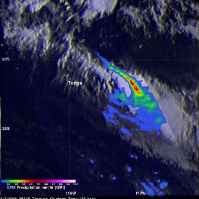
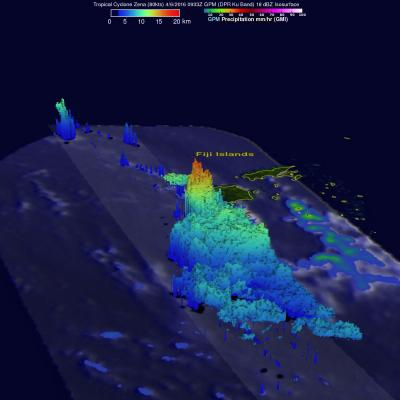
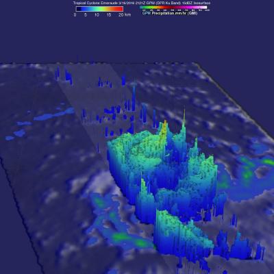
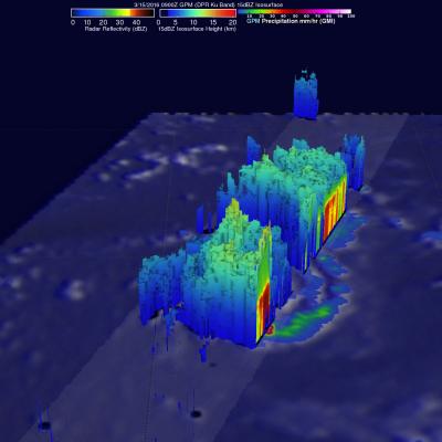
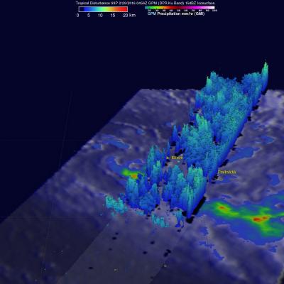
GPM Sees Potential Atlantic Tropical Cyclone

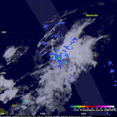
An area of low pressure located in the Atlantic Ocean between Bermuda and the Bahamas is being monitored today for possible development into a tropical or subtropical cyclone. Shower activity has increased in the area. The National Hurricane Center (NHC) has advised interests along the southeastern coast of the United States to monitor the progress of this low. The GPM core observatory satellite flew over this showery area on May 26, 2016 at 0932 UTC (5:30 AM EDT). GPM's Microwave Imager (GMI) and and Dual-Frequency Precipitation Radar (DPR) instruments measured precipitation around the low
Creating Digital Hurricanes
Every day, scientists at NASA work on creating better hurricanes – on a computer screen. At NASA’s Goddard Space Flight Center in Greenbelt, Maryland, a team of scientists spends its days incorporating millions of atmospheric observations, sophisticated graphic tools and lines of computer code to create computer models simulating the weather and climate conditions responsible for hurricanes. Scientists use these models to study the complex environment and structure of tropical storms and hurricanes. Getting the simulations right has huge societal implications, which is why one Goddard...

Tropical Cyclone Fantala's Changes Observed By GPM

As expected, tropical cyclone Fantala reversed course and moved southeastward almost directly over it's earlier track. The tropical cyclone's intensity also fluctuated. Maximum winds dropped significantly as Fantala moved southeastward but have rebounded somewhat today. The GPM core observatory satellite flew over the tropical cyclone on April 19, 2016 at 1346Z when winds had dropped to about 95 kts (109 mph). At that time GPM's Microwave Imager (GMI) and Dual-Frequency Precipitation Radar (DPR) found that Fantala still contained extremely heavy rainfall in storms spiraling into the tropical

GPM Views Increasingly Powerful Tropical Cyclone Fantala

Tropical cyclone Fantala has continued to intensify while moving westward over the open waters of the South Indian Ocean. The GPM core observatory satellite passed directly over Fantala's eye on April 14, 2016 at 0148 UTC. At that time the tropical cyclone had maximum sustained winds estimated at 90 kts (104 mph) making in the equivalent of a category two tropical cyclone on the Saffir-Simpson hurricane wind scale. GPM's Microwave Imager (GMI) and Dual-Frequency Precipitation Radar (DPR) instruments again captured data that were used to estimate rainfall within Fantala. Rain was measured by

Tropical Cyclone Fantala Formation Seen By GPM

A tropical cyclone called Fantala formed in the South Indian Ocean far to the east of Madagascar on on April 11, 2016. Fantala has slowly intensified while moving westward and is expected become even more powerful. The GPM core observatory satellite flew over Fantala (TC19S) on April 10, 2016 at 0206 UTC when the tropical cyclone was forming. The first image shows a rainfall analysis using data captured with by GPM's Microwave Imager (GMI) and Dual-Frequency Precipitation Radar (DPR) instruments. GPM rainfall is shown overlaid on a 0200Z METEOSAT-7 Visible and Infrared image. Intense

Weakening Tropical Cyclone Zena's Rain Measured By GPM

Heavy rain was reported as weakening tropical cyclone Zena passed quickly by Tonga. Tropical cyclone Zena was in the process of being torn apart with strong vertical wind shear. The GPM core observatory satellite passed above Zena on April 7, 2016 at 0841 UTC after the center of the tropical cyclone had moved to the east-southeast of Tonga. Zena's maximum sustained winds had dropped to about 35 kts (40 mph). Rainfall derived from GPM's Microwave Imager (GMI) data are shown overlaid on a 0900 UTC GOES-WEST enhanced infrared image. GPM's GMI revealed that weakening tropical cyclone Zena still

GPM Sees More Powerful Tropical Cyclone Zena

Tropical cyclone Zena intensified over the open waters between Vanuatu and Fiji. At peak intensity Zena had sustained winds estimated at about 90 kts (104 mph). The GPM core observatory satellite had an excellent view of tropical cyclone Zena on April 6, 2016 at 0933 UTC when tropical cyclone Zena was located southwest of Fiji. Zena had started to weaken but still had maximum sustained wind speeds estimated at 80 kts (92 kts). An analysis of GPM's Microwave Imager (GMI) and Dual-Frequency Precipitation Radar (DPR) data revealed the intensity of some very heavy showers in the tropical cyclone

Tropical Cyclone Emeraude Viewed By GPM

As expected, tropical cyclone Emeraude formed on March 15, 2016 from a tropical low (99s) in the South Indian Ocean. The GPM core observatory satellite flew above intensifying Emeraude on March 16, 2016 at 2121Z after the tropical cyclone's maximum sustained winds had increased to greater than 90 kts (103.5 mph). Rainfall just northwest of Emeraude's eye was measured by GPM's Dual-Frequency Precipitation Radar (DPR) instrument falling at a rate of over 209 mm (8.2 inches) per hour. The powerful thunderstorms producing this extreme rainfall were measured by GPM's radar (DPR) reaching an

GPM Spots Potential South Indian Ocean Tropical Cyclone

The GPM Core Observatory satellite saw possible tropical cyclone formation in the South Indian ocean on March 15, 2016 at 0900 UTC. A rainfall analysis using data collected by GPM's Microwave Imager (GMI) and Dual-Frequency Precipitation Radar (DPR) shows rain bands wrapping around a tropical low. GPM's DPR measured rain falling at the extreme rate of over 220 mm (8.7 inches) per hour in powerful storms south of the low's center of circulation. GPM's radar (DPR Ku Band) data were able to show the 3-D structure of precipitation within the tropical low. Storm tops heights were measured by GPM

GPM See Potential Tropical Cyclone

The GPM core observatory satellite flew over an area of disturbed weather in the South Pacific near Bora Bora early today where a tropical cyclone may be forming. On February 29, 2016 at 0456 UTC GPM's Microwave Imager (GMI) saw rain falling at an estimated rate of almost 48 mm (1.9 inches) per hour in an area of deep convection south of a tropical low. GPM's Dual-frequency Precipitation Radar (DPR) instrument measured cloud top heights at an altitude of over 10.5 km (6.5 miles) in rain showers between Bora Bora and Tahiti.