tropical cyclones

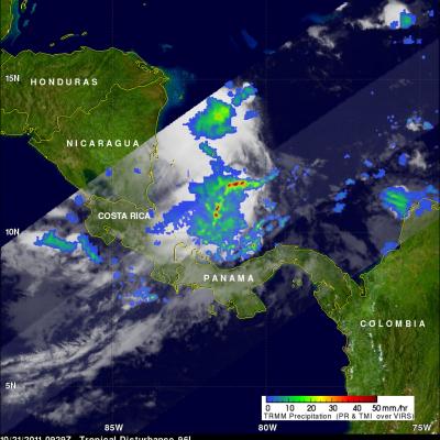
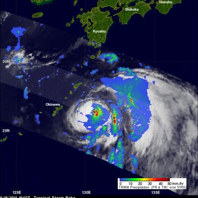
TRMM sees Powerful Tropical Cyclone Funso

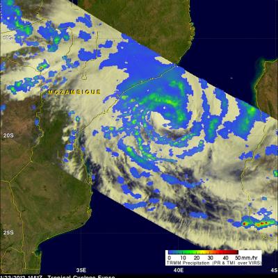
The TRMM satellite had a good view of powerful tropical cyclone Funso battering the Mozambique coast when it flew over on 23 January 2012 at 1451 UTC. TRMM data shows that Funso was dropping moderate to heavy rainfall in bands covering the Mozambique channel from eastern Mozambique to western Madagascar. Storms and floods from Funso have killed at least 22 people and forced tens of thousands from their homes in Mozambique. Tropical cyclone Funso formed in the Mozambique channel off the coast of Mozambique on 19 January 2012. The image above shows what TRMM saw on 21 January 2012 when Funso had

Tropical Cyclone Thane Hits India

At least 33 people were killed when tropical cyclone Thane with reported winds of up to 85 mph hit the southeastern coast of India Friday morning. The TRMM satellite saw the tropical cyclone several times from it's birth in the Bay of Bengal to it's strengthening to hurricane force before penetrating the Indian coast. Thane was a tropical storm with winds of about 40kts when TRMM passed above on 26 December 2011 at 1305 UTC. The storm was starting to organize with TRMM Precipitation Radar (PR) revealing a large area of powerful storms surrounding the northern side. A TRMM Microwave Imager (TMI

Philippines Devastated by Tropical Storm Washi

Washi, known locally in the Philippines as Sendong, began as a tropical depression on the 13th of December 2011 in the West Pacific Ocean about 2150 km (~1333 miles) due east of the southern Philippines. Washi only intensified slightly and never exceeded tropical storm intensity as it tracked due west towards the southern Philippines' island of Mindanao. Washi made landfall on the east coast of Mindanao on the afternoon of the 16th as a moderate tropical storm with sustained winds reported at 55 knots (~63 mph). Despite its modest intensity, Washi had a huge impact on the island. As Washi made

Tropical Storm 27W Forming

Tropical Cyclones can form in the western Pacific Ocean at any time during the year but they occur most frequently during the months of June through November so tropical storm 27W is a little unusual. The TRMM satellite saw what was then tropical depression 27W on 13 December 2011 at 1533 UTC. It was upgraded to a Tropical storm by the Joint Typhoon Warning Center (JTWC) the next day at 0900 UTC. TRMM's Microwave Imager (TMI) shows that moderate rainfall was located in clusters of strong convective storms within the developing tropical cyclone. Tropical storm 27W has been predicted to

Another Possible Tropical Cyclone Approaches Oman

On November 2011 at 1541 UTC the TRMM satellite passed over another stormy area heading toward Oman from the Arabian sea . Another tropical cyclone may be forming in this area less than a week after deadly tropical storm Keila hit Oman. A rainfall analysis from TRMM's Microwave Imager (TMI) and Precipitation Radar (PR) is shown in the image above. Rainfall derived from PR data, shown in a lighter shade, reveals that an area of extremely heavy rainfall was located in the center of this stormy area. TRMM's PR data were again used to show the 3-D structure of this stormy area. Some of these very

Potential Tropical Cyclone Development In The Caribbean

The TRMM satellite passed over an area of disturbed weather in the southern Caribbean Sea between Nicaragua and Jamaica on 21 October 2011 at 0929 UTC. The National Hurricane Center (NHC) has given this area a high chance (60%) of becoming a tropical cyclone over the weekend. Data from TRMM's Precipitation Radar (PR) instrument were used to make the 3-D image above that shows that a cluster of strong convective storms in the southern part of this area were higher than 15 km (~9.3 miles). The heavy rainfall in this area of deep convection releases heat, known as latent heating, into these

TRMM Used to Examine the Bay of Bengal Tropical Cyclone

The accurate measurement of the tropical rainfall around the globe is one of the main objectives of the TRMM satellite. The TRMM satellite has also proven useful for global monitoring of tropical cyclone development. The images above were made from data received by the TRMM satellite when it passed over tropical cyclone 02B in the eastern Bay Of Bengal on 19 October 2011 at 2340 UTC. The image above shows a rainfall analysis that was made from TRMM's Microwave Imager (TMI) and Precipitation Radar (PR) data. It shows that moderate to heavy rainfall associated with 02B was extending

TRMM Views Area Of Possible Tropical Cyclone Development

The TRMM satellite flew over an area of disturbed weather in the southeastern Gulf Of Mexico on 17 October 2011 at 1310 UTC (9:10 AM EDT). The National Hurricane Center (NHC) has given this area of low pressure a medium chance (40%) of becoming a tropical cyclone during the next 48 hours. A rainfall analysis from TRMM's Microwave Imager (TMI) and Precipitation Radar (PR) data shows that a large area of rainfall associated with this disturbance extends from the northern tip of Mexico's Yucatan Peninsula to the southwest coast of Florida. Several stormy areas within this disturbed weather are

Tropical Cyclones bring Heavy Rains to the Far East

Over a period of 10 days, a series of three tropical cyclones brought heavy rains and devastating flooding to parts of the Philippines, southern China and Vietnam. The first of these storms to form--and the most devastating--was Typhoon Nesat, which began in the central Philippine Sea. This storm intensified as it tracked westward reaching Category 3 intensity just before making landfall on the northern Philippines island of Luzon early on the morning of the 27th of September. It brought heavy rains and widespread flooding to the region and was initially blamed for 56 fatalities in the

Two Tropical Cyclones Near Japan

The TRMM satellite flew over two tropical cyclones near Japan on 18 September 2011. Typhoon Sonca, shown above, was seen off the east coast of the main Japanese island of Honshu at 1805 UTC while moving away from Japan toward the north-east. Sonca was still a powerful typhoon with wind speeds of about 85 knots (~98 mph) at that time but Sonca weakened to a tropical storm on 19 September 2011 while moving over the colder waters of the northern Pacific Ocean to the north-east of Japan. TRMM saw tropical storm Roke a little later at 1840 UTC. TRMM Precipitation Radar (PR) data shows that Roke