tropical cyclones

TRMM Sees Tropical Cyclone Amara Forming

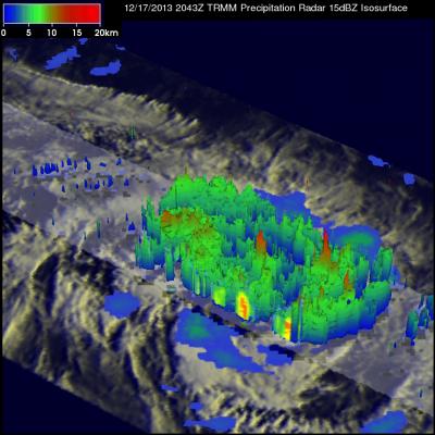
Yesterday Amara became the third tropical cyclone since October 2013 to form in the South Indian Ocean. TRMM Microwave Imager (TMI) and Precipitation Radar (PR) data captured by the TRMM satellite on December 16, 2013 at 2043 UTC were used in the image on the upper left. TRMM's Microwave Imager (TMI) and Precipitation Radar (PR) instruments showed that Amara was getting organized with scattered bands of moderate to heavy rain spiraling into the tropical cyclone's center. TRMM PR located some strong radar reflectivity values of over 47.7 dBZ in rain falling at a rate of over 76.9 mm/hr (~3

TRMM Sees Powerful Storms In Tropical Cyclone Madi

The TRMM satellite flew over tropical cyclone Madi in the Bay Of Bengal on December 11, 2013 at 1034 UTC. TRMM's Microwave Imager (TMI) and Precipitation Radar (PR) instruments found that Madi contained powerful storms southeast of Madi'a center of circulation dropping rain at the rate of over 81 mm/hr (~3.2 inches). An analysis of Madi's 3-D vertical structure using TRMM PR found that tops of these convective towers were reaching extremely high altitudes greater than 19km(~11.8 miles). Tropical cyclone Madi is predicted by the Joint Typhoon Warning Center (JTWC) to weaken while moving over

Philippine's Tropical Cyclone Rainfall 2013

In a normal year 30% of the total rainfall near the Philippines (northwestern Pacific Ocean) is caused by tropical cyclones. The most notable tropical cyclone this year was deadly super typhoon HAIYAN that devastated the central Philippines in November 2013. The TRMM-based, near-real time Multi-satellite Precipitation Analysis (TMPA) at the NASA Goddard Space Flight Center was used to analyze only rainfall near tropical cyclones passing close to or over the the Philippines in 2013. The TMPA analysis above shows the estimated total rainfall contributed by named tropical cyclones this year. Red

Tropical Cyclone Lehar Moving Toward India

Tropical cyclone LEHAR, located in the Bay Of Bengal, continues to gain intensity while heading toward the same area of India where a much weaker tropical cyclone HELEN recently came ashore. The Joint Typhoon Warning Center (JTWC) predicts that LEHAR's sustained wind speeds will reach 95 kts (~109 mph) on November 27, 2013 and then decrease to about 85 kts (~98 mph) before hitting India's east-central coast. The TRMM satellite flew above tropical cyclone LEHAR on November 26, 2013 at 0307 UTC and captured data used in the image above. Rainfall derived from TRMM's Microwave Imager (TMI) and

Tropical Cyclone Lehar In The Bay Of Bengal

Today tropical cyclone LEHAR's estimated sustained wind speeds reached 65kts (~75 mph). The most powerful tropical cyclone in the Bay Of Bengal this year was deadly tropical cyclone PHAILIN that moved through the area in October with wind speeds of 140kts (~161 mph). This means that LEHAR is the second most powerful tropical cyclone to form in the Bay Of Bengal this year. The TRMM satellite collected data used in the image on the left when the TRMM satellite passed above LEHAR on November 24, 2013 at 1812 UTC. At that time LEHAR was intensifying with tropical storm force winds estimated to be

Tropical Cyclone Helen Hits India

Tropical cyclone Helen was the fourth named tropical cyclone in the Bay Of Bengal this year when it formed on November 19, 2013. The image on the left shows tropical cyclone Helen as the TRMM satellite flew over on November 21, 2013 at 0606 UTC when Helen had reached peak intensity of about 60kts (~69 mph). The image on the right uses data captured on November 22, 2013 at 0510 UTC when tropical cyclone HELEN was hitting India's east-central coastline. Precipitation data derived from TRMM's Microwave Imager (TMI) and Precipitation Radar (PR) instruments show that Helen was dropping rain at a

Mexico Flooded by Tropical Storm Manuel and Hurricane Ingrid

Mexico's Pacific and Gulf coasts were both inundated by deadly tropical rainfall at the same time. Tropical storm Manuel dropped extremely heavy rainfall along Mexico's Pacific coast. At least 55 people have been reported killed in Mexico due to flooding and landslides caused by extreme rainfall. Hurricane Ingrid weakened to a tropical storm and came ashore from the Gulf Of Mexico into the state of Tamaulipas near La Pesca, Mexico on Monday September 16,2013. The approximate 0000Z and 1200Z locations of the tropical cyclones are shown overlaid in white. The TRMM-based, near-real time Multi-

Deadly Tropical Cyclone Mahasen Comes Ashore

Tropical cylone Mahasen hit southern Bangladesh causing the reported deaths of at least 12 people and the destruction of many homes. Mahasen had heavy rains accompanied with tropical storm force winds when it came ashore. The TRMM satellite had two very informative views as deadly tropical Cyclone Mahasen was moving toward and then over Bangladesh. TRMM passed above Mahasen on May 15, 2013 at 2133 UTC and saw Mahasen again on May 16, 2013 at 0406 UTC after the tropical cyclone's center passed over Bengladesh's Ganges Delta. Red tropical cyclone symbols mark Mahasen's locations with both TRMM

TRMM Sees Tropical Cyclone 01B

The TRMM satellite passed above a developing tropical cyclone in the northern Indian Ocean west of Indonesia on May 9, 2013 at 2211 UTC. This image shows that tropical cyclone 01B was already fairly well organized. TRMM's Precipitation Radar (PR) instrument indicated that rainfall was falling at a rate over 178 mm/hr (~5.8 inches) in an area of strong convection in the middle of the forming tropical cyclone. The tropical cyclone is a little unusual because it formed only 4.8 degrees north of the equator. Coriolis force, an artifact of the earth's rotation, is weaker near the equator so