tropical cyclones

Eastern Pacific Tropical Cyclone Forming

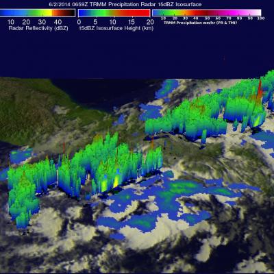
The eastern Pacific Ocean has become active on cue with the start of the hurricane season in that area. Only a few days after hurricane Amanda weakened and disappeared the National Hurricane Center (NHC) says that development of another tropical cyclone is probable southeast of Salina Cruz, Mexico. The image above shows rainfall data captured by the TRMM satellite as it flew over on June 2, 2014 at 0659 UTC. TRMM's Microwave Imager (TMI) and Precipitation Radar (PR) data are shown overlaid on an enhanced infrared image from the GOES-EAST satellite received at 0645 UTC. TRMM found areas of
NASA Widens 2014 Hurricane Research Mission
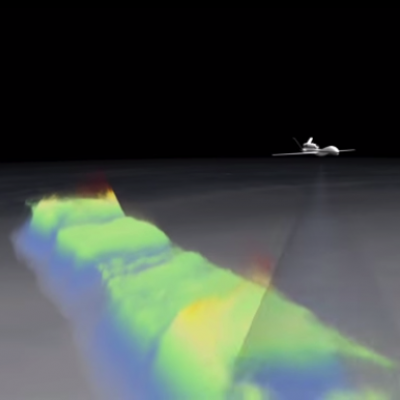
NASA's airborne Hurricane and Severe Storm Sentinel or HS3 mission, will revisit the Atlantic Ocean for the third year in a row. Image Credit: NASA's Goddard Space Flight Center/Ryan Fitzgibbons Download this video in HD formats from NASA Goddard's Scientific Visualization Studio During this year's Atlantic hurricane season, NASA is redoubling its efforts to probe the inner workings of hurricanes and tropical storms with two unmanned Global Hawk aircraft flying over storms and two new space-based missions. NASA's airborne Hurricane and Severe Storm Sentinel or HS3 mission, will revisit the...

Possible Eastern Pacific Tropical Cyclone Formation

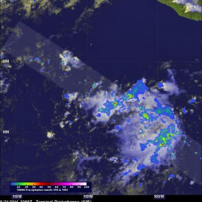
The Eastern Pacific hurricane season began on May 15, 2014 and today a potential tropical cyclone is forming south-southwest of Manzanillo, Mexico. The TRMM satellite collected data as it flew above this area on May 21, 2014 at 2259 UTC. TRMM's Precipitation Radar (PR) found rain falling at over 102.5 mm/hr (about 4 inches) in some convective showers and thunderstorms in this area. A GOES-WEST image was overlaid with a rainfall analysis from TRMM PR and TMI. TRMM's Precipitation Radar (PR) data were used to show a 3-D view of the rainfall structure in this disturbed weather. A few strong

Tropical Cyclone Ita Drenches Australia

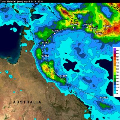
After coming ashore this past Friday tropical cyclone ITA dropped heavy rainfall over the weekend that caused flooding in many areas of northeastern Australia's state of Queensland. IDA has now moved back into the Coral Sea. The analysis above shows a TRMM-based near-real time Multi-satellite Precipitation Analysis (TMPA) made at the NASA Goddard Space Flight Center. This analysis used TMPA precipitation data from April 1-14, 2014 during the period when ITA formed in the Coral Sea and moved along northeastern Australia's coast. IDA's locations at 0600 UTC are shown overlaid in white. The

Powerful Tropical Cyclone Ita Hits Australia

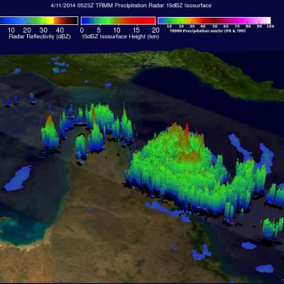
As predicted, powerful tropical cyclone ITA hit the Queensland coast of northeastern Australia late Friday (local time). At that point ITA was a category four on the Saffir-Simpson hurricane intensity scale with winds estimated at over 120 kts (about 138 mph) . This intensity was down slightly from ITA's estimated peak sustained wind speed of 135kts (about 155 mph) when the dangerous tropical cyclone was approaching Australia. The TRMM satellite passed almost directly above as tropical cyclone ITA was approaching the Queensland coast on April 11, 2014 at 0523 UTC. At the time of this TRMM view

TRMM Sees Powerful Tropical Cyclone Ita Approaching Queensland, Australia

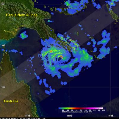
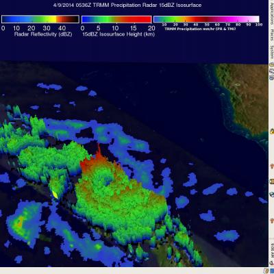
Tropical cyclone ITA, located in the Coral Sea northeast of Australia, continues to intensify while heading toward the northeastern coast of Australia. ITA was seen twice by the TRMM satellite on April 9, 2014. The tropical cyclone's wind speeds had increased from 65kts (about 75 mph) with the first pass at 0536 UTC to 80kts (about 92 mph) when viewed again at 1528 UTC. ITA is predicted to continue becoming more powerful and have sustained winds of 135 kts (about 188 mph) before hitting Australia's Queensland coast tomorrow. TRMM's Precipitation Radar (PR) instrument sliced through ITA's eye

Tropical Cyclone Ita Intensifies

The TRMM satellite flew above intensifying tropical cyclone ITA in the Coral Sea near the southeastern tip of Papua New Guinea on April 9, 2014 at 0536 UTC. The tropical cyclone had developed a large but well defined eye and had sustained winds estimated at 65kts (about 75mph). Rainfall derived from TRMM's Microwave Imager (TMI) and Precipitation Radar (PR) data was used in the analysis shown here. TRMM PR data unveiled rain falling at a rate of over 99mm/hr (about 3.9 inches) within ITA's feeder bands over the coast of southeastern Papua New Guinea. TRMM PR found that tall thunderstorms in

Tropical Cyclone Hellen's Lively Remnants

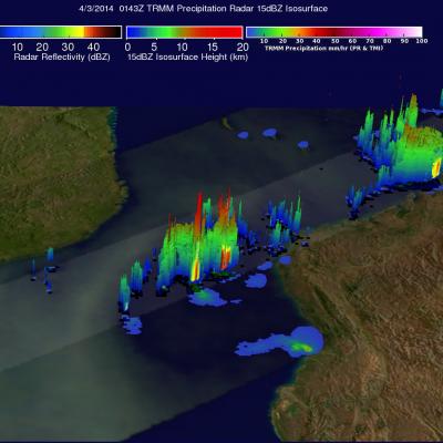
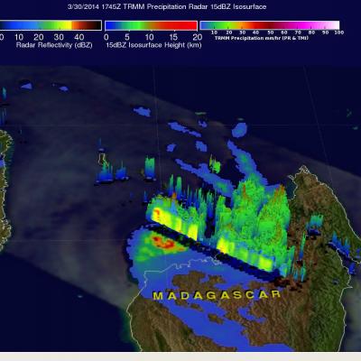
Powerful tropical cyclone Hellen rapidly weakened after hitting northwestern Madagascar but Hellen's remnants have recently started to show signs of life. The TRMM satellite flew over these remnants in the Mozambique channel on April 2, 2014 at 0143 UTC. A rainfall analysis using TRMM's Microwave Imager (TMI) and Precipitation Radar (PR) instruments found that some strong convective thunderstorms had developed in the area. It was revealed by TRMM PR data that rain was falling at a rate of over 75 mm/hr (almost 3 inches) in a few locations.
Tropical Cyclone Hellen JacobAdmin Wed, 04/02/2014
Tropical cyclone HELLEN formed in the Mozambique channel northwest of Madagascar on March 28, 2014. HELLEN became a very powerful tropical cyclone with peak sustained winds of 130kts (about 150 mph) on March 30, 2014. HELEN's eye came ashore in northwestern Madagascar On March 31, 2014 with winds predicted to be about 95kts (~109 mph). HELEN is now expected to gradually weaken over northwestern Madagascar while moving southwestward and be over the Mozambique Channel again on April 1, 2014. The TRMM satellite passed above HELLEN on March 30, 2014 at 1747UTC when the tropical cyclone was close

GPM's Stormy New View

Submitted by JacobAdmin on Tue, 03/25/2014
Video Embed

On March 10, the Core Observatory passed over an extra-tropical cyclone On March 10, the Core Observatory passed over an extra-tropical cyclone about 1055 miles (1700 kilometers) due east of Japan's Honshu Island. Satellite data shows the full range of precipitation in the storm. 

Learn More