tornadoes

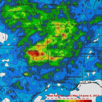
A Week of Violent Weather And Heavy Rainfall

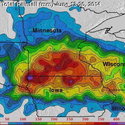
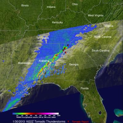
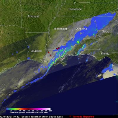
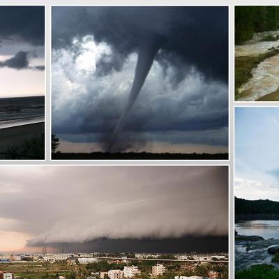
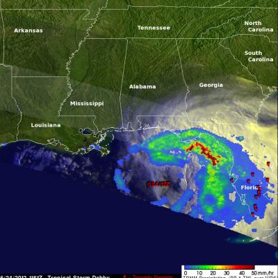
Over the past seven days stormy weather has spawned tornadoes and dropped extremely heavy rainfall in the Northern Plains and the Great Lakes states. This deluge has caused flooding in South Dakota, Minnesota, Iowa, Wisconsin and Illinios. There have been concerns about the Mississippi, Big Sioux and Rock River Rivers escaping their banks. For more than sixteen years rainfall has been monitored by the TRMM-based, near-real time Multi-satellite Precipitation Analysis (TMPA) . These products have been developed at the NASA Goddard Space Flight Center by the precipitation research team. (TMPA)

Deadly Tornadoes Hit Southern States For Second Day

For the second day in a row deadly tornadoes hit the the southern United States. Mississippi was the hardest hit with nine people killed by tornadoes that hit Tupelo. The TRMM satellite had two good views as extreme weather continued moving through the area on Monday April 28, 2014 at 11:00 PM CDT (April 29, 2014 at 0400 UTC) and early Tuesday April 29, 2014 at 00:38 AM CDT (0538 UTC). Rainfall derived from TRMM's Microwave Imager (TMI) and Precipitation Radar (PR) data is shown overlaid on GOES-EAST infrared satellite images captured on April 29, 2014 at 0402 UTC and 0532 UTC. Red symbols

TRMM Sees Tornadic Thunderstorms

The TRMM satellite passed above a line of severe thunderstorms over the eastern United States on February 21, 2014 at about 1148UTC (6:48 AM EST). Several reports of tornadoes in Illinois were associated with this system yesterday. A possible tornado was reported in Georgia this morning. The 3-D image below shows a TRMM Precipitation Radar (PR) slice through the line of severe thunderstorms. One tall thunderstorm in the Florida panhandle was shown reaching heights of about 13.8km (~8.5 miles) and returning Radar reflectivity values of over 58dBZ to the satellite. Rain was found by TRMM PR to
IFloodS Observes Severe Storm Outbreak
Development of low storm clouds in the atmospheric mixing layer over the NPOL and D3R radars on June 12, 2013 at ~12:00 p.m. CDT. Credit: Walt Petersen /NASA . On Wednesday afternoon, June 12, a severe storm outbreak developed and moved across central and eastern Iowa, and then western Illinois, spawning huge thunderstorms and several tornadoes. NASA's Polarimetric (NPOL) precipitation radar, currently deployed in Iowa as part of the Iowa Flood Studies field campaign for the Global Precipitation Measurement mission, rapidly scanned these storms as they moved across the state. NPOL capturing...

Deadly Tornadoes and Flooding Rainfall in the U.S.

Last week's flooding and tornadoes caused the reported deaths of at least 18 people in Oklahoma. Today extensive flooding from heavy rainfall occurred in Missouri when a levee was breached. The TRMM-based, near-real time Multi-satellite Precipitation Analysis (TMPA) at the NASA Goddard Space Flight Center was used in this analysis to show rainfall over these areas. TRMM with its combination of passive microwave and active radar sensors was used to calibrate rainfall estimates from other satellites. TMPA rainfall totals are shown here for the 21-day period from May 14 to June 4, 2013. Heavy

Early Spring-like Storm Brings Severe Weather, Tornadoes to the Southeast

Despite it only being the end of January, a large spring-like storm system recently swept through the central and eastern part of the country, bringing a surge of warm air northward over the eastern third of the country and a threat for severe weather over much of the southeast as a strong jet stream dove down out of the Rockies southward to the northern Gulf Coast before racing northward again on the western side of the Appalachians. TRMM captured this image of a long line of strong storms associated with an advancing cold front stretching from southwest Alabama up through the central part of
TRMM Sees Tornado Spawning Thunderstorms JacobAdmin Tue, 12/11/2012
In the United States tornadoes develop most often in the spring when warm moist unstable air accompanies strong fronts and fluctuating upper-air systems. There is a also a slight increase in tornado activity in late October and November. Tornadoes form least often in December and January so the tornadoes that occurred yesterday over the south-eastern United States were unusual. The TRMM satellite was flying over on December 10, 2012 at 1743 UTC (12:43 PM EST) and captured data showing tornado spawning thunderstorms within a frontal system moving through Louisiana, Mississippi, Alabama, Georgia
Shelf cloud approaching the beach.
Thank you to everyone who submitted photos to the first installment of our GPM Extreme Weather Photo Competition. We loved all of your entries and thoroughly appreciate your participation! The GPM Photo Competition Committee is happy to announce our top 5 picks. We’ll be sending the submitters NASA bags and GPM stickers. Please stay tuned for additional contests and activities. Ormond Shelf, by Jason Weingart Date and Location: May 15, 2012 Ormond Beach, Florida How this Photo Was Taken: “I'm a photography student at the University of Central Florida. I began chasing storms a little over three...
GPM Extreme Weather Photo Contest
Powerful weather systems like thunderstorms and tornadoes are awesome displays of the force of nature. Now NASA wants to display YOUR photos of extreme weather! Post your coolest photographs and we'll pick the best ones to feature on the NASA Precipitation Measurement Missions websites (http://pmm.nasa.gov/ & http://www.nasa.gov/GPM). While we want extreme weather, we don't want YOU to be too extreme. So before you take that photo, please make sure you're keeping safe. Submission Guidelines: Submit your photo's to the GPM Extreme Weather Flickr group: http://www.flickr.com/groups/gpm-extreme...

Tropical Storm Debby Threatens Florida Gulf Coast

Tropical Storm Debby formed on the 23rd of June 2012 in the central Gulf of Mexico, becoming the earliest 4th named storm on record. Debby began as an area of low pressure that moved out of the northwestern Caribbean and into the Gulf. After forming on the afternoon of the 23rd, Debby has moved very slowly under the influence of weak steering currents. Debby drifted ever so slowly northward on the night of the 23rd before turning northeast later on the morning of the 24th towards the northeast Gulf Coast of Florida. Despite its slow forward progress and lack of intensification, Debby has