tornadoes

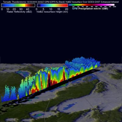
GPM Satellite Examines Tornadic Thunderstorms

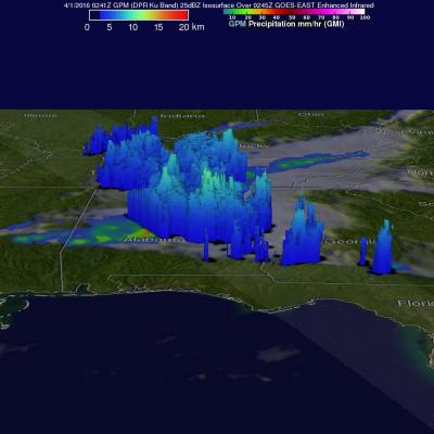
Over the past few days tornado spawning thunderstorms have occurred in the states of Texas, Oklahoma, Arkansas, Louisiana, Indiana, Mississippi, Alabama and Georgia. Large hail, damaging winds, and flash flooding associated with a frontal system moving across the United States have compounded the damage from these storms. Hail the size of a half-dollar was reported near Jackson, Louisiana on Thursday evening. The GPM core observatory satellite flew over this stormy area on April 1, 2016 at 0241 UTC (March 31, 2016 at 10:41 PM EDT). Tornadoes were reported in Mississippi, Alabama and Georgia

Early Spring Storm Brings Snow to Parts of Colorado, Midwest

A strong, upper-level trough that dropped down into the Central Rockies in the middle of last week produced an early spring storm (also referred to as Winter Storm Selene) that dumped heavy snow on the order of a foot or more in a short period of time along the Front Range of Colorado from near Colorado Springs northward through Denver and up into southeastern Wyoming. Around 2 feet of snow were reported in places like Aurora and Boulder with some of the highest totals reaching 31 inches. Farther to the north, Cheyenne, Wyoming picked up over 14 inches of snow from the storm. The blizzard

GPM Views Severe Weather And Heavy Rain in the U.S.

The GPM satellite flew above storms in the southwestern United States this morning (March 9, 2016) at 1011 UTC (5:11 CST). Severe weather has been moving slowly through this area for the past couple days. Two tornadoes developed in north central Texas yesterday morning (March 8, 2016). This morning rain was measured by GPM's Dual-Frequency Precipitation Radar (DPR) instrument falling at the extreme rate of over 148 mm (5.8 inches) in one powerful storm over eastern Texas. GPM's radar (DPR Ku Band) found that a few thunderstorm tops in this area were reaching altitudes above 13.7 km (8.5 miles)

Extreme Precipitation Measured From Space

For over a week the weather over the continental United State's has been punctuated by extreme events. Automobiles were thrown around on January 27, 2016 by tornadoes that hit southern Florida. On January 31 a winter storm with heavy rain, strong winds and isolated thunderstorms hit southern California killing at least one person. There were numerous reports of hail with these storms ranging from pea sized to up to an inch in diameter. Powerful winds with these storms also brought down trees and power lines. A blizzard that followed the Democratic and Republican caucuses in Iowa dropped over

GPM 2015: One Year of Storms

Submitted by JacobAdmin on Mon, 01/11/2016
Video Embed

As we enter the new year, take a look back at the snowstorms, tropical storms, typhoons, hurricanes and floods captured and analyzed by the Global Precipitation Measurement (GPM) mission from around the globe during 2015. 

The complete list of storms by date and location are as follows:

1. New England Nor’easter – January 26 – New England, USA
2. Snowstorm – February 17 – Kentucky, Virginia and North Carolina, USA
3. Tornadic Thunderstorms in Midwest – March 25 – Oklahoma and Arkansas, USA

<iframe width="490" height="276" src="https://www.youtube.com/embed/oiGzKmfOvkg?rel=0" frameborder="0" allowfullscreen></iframe>
As we enter the new year, take a look back at the snowstorms, tropical storms, typhoons, hurricanes and floods captured and analyzed by the Global Precipitation Measurement (GPM) mission from around the globe during 2015. The complete list of storms by date and location are as follows: 1. New England Nor’easter – January 26 – New England, USA 2. Snowstorm – February 17 – Kentucky, Virginia and North Carolina, USA 3. Tornadic Thunderstorms in Midwest – March 25 – Oklahoma and Arkansas, USA 4. Typhoon Maysak – March 30 – Yap Islands, Southwest Pacific Ocean 5. Rain Accumulation from Cyclone...

NASA Looks At Deadly Weather Over the US

Heavy rainfall, flooding and tornado outbreaks affected areas of the United States from the Southwest through the Midwest from December 23-27, 2015. Tornadoes and flooding events killed at least 43 people during this period. Fourteen deaths alone occurred with tornadoes that hit Benton, Mississippi on December 23, 2015. Tornadoes are expected in the springtime but are much less frequent during this time of the year. An analysis was made of the rainfall that occurred during the period from December 21-28, 2015. This analysis used data generated by NASA's Integrated Multi-satellitE Retrievals

GPM Sees Weekend Texas Tornadoes

Stormy spring weather over the Southwest popping up during the past weekend with at least twenty tornadoes sightings over Texas on Sunday April 26, 2015. The GPM core Observatory satellite had a good view of severe storms developing yesterday through central Texas when it flew over at 2134 UTC (4:42 PM CDT). Large hail and heavy rainfall was associated with some of these storms. This image shows a 3-D view of severe weather over Texas using data from the first space-borne Ku/Ka-band Dual-frequency Precipitation Radar (DPR) on board the GPM Core Observatory satellite. Ku Band radar from this

A GPM View of Tornado Spawning Thunderstorms

Twelve tornado sightings reported to NOAA yesterday were associated with severe thunderstorms extending from the Texas Gulf coast, through Oklahoma and Kansas. The GPM core observatory satellite had a good look at this area of severe weather on April 17, 2015 at 0003 UTC (April 16, 2015 at 7:03 PM CDT). A precipitation analysis using GPM's Microwave Imager (GMI) shows that some of these severe storms were dropping rain at a rate of over 86 mm (about 3.4 inches) per hour. Reflectivity data from the Ku band on GPM's dual frequency radar was used to construct this 3-D view of tornado spawning

Tornadoes Hit Southwest

Seven Tornadoes were reported yesterday in a line of violent thunderstorms extending over Oklahoma and Arkansas. One death was reported in a tornado that hit near Tulsa, Oklahoma. The TRMM satellite flew over this line of deadly storms on March 25, 2015 at 11:21 CDT ( March 26, 2015 at 0321 UTC). The first image shows a rainfall analysis that was formed from data collected by TRMM's Microwave Imager (TMI) and Precipitation Radar (PR) instruments at the time of this pass. TRMM PR data indicated that rain was falling at the extreme rate of over 172 mm (6.8 inches) per hour in some powerful