Texas

IMERG Sees Winter Storms Impact the Southern U.S.
In mid-February 2021, large areas of the Continental United States experienced extreme cold temperatures as a result of a strong Arctic high pressure system. The cold temperatures were accompanied by several pulses of precipitation over the Southeast US through the mid-Atlantic, as well as the Pacific Northwest. The combination of cold temperatures and precipitation resulted in widespread power outages to millions of people in Texas, Kentucky, West Virginia, and Oregon, among other states.

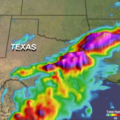
Southern Texas' Flooding Rainfall Examined With IMERG

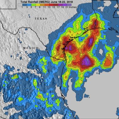
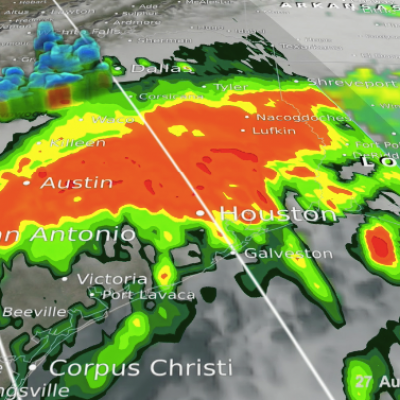
Extremely heavy rainfall caused a flash flood emergency over southern Texas this week. More than 15 inches (381 mm) of rain fell in Hidalgo County, Texas since Tuesday June 19, 2018. The Governor of Texas declared a state of emergency for six counties in South Texas Thursday afternoon. Heavy rain had ended Friday morning but occasional showers were still occurring over southern Texas. At 4:28 AM CDT Friday June 22, 2018 the National Weather Service in Brownsville, Texas issued a "Flood Warning for Urban Areas and Small Streams in... Southwestern Hidalgo County in Deep South Texas..."
GPM Captures Hurricane Harvey's Rainfall
Music: "Whirlpool," Michael Jan Levine, Killer Tracks The Global Precipitation Measurement (GPM) Core Observatory captured these images of Hurricane Harvey at 11:45 UTC and 21:25 UTC on the 27th of August nearly two days after the storm made landfall as it was meandering slowly southeast at just 2 mph (~4 kph) near Victoria, Texas west of Houston. The image shows rain rates derived from GPM's GMI microwave imager (outer swath) and dual-frequency precipitation radar or DPR (inner swath) overlaid on enhanced visible/infrared data from the GOES-East satellite. Harvey's cyclonic circulation is...

NASA's IMERG Shows Rainfall Accumulation Along Harvey's Track

Total rainfall estimates from NASA's Integrated Multi-satelliE Retrievals for GPM (IMERG) data are shown here for the period from August 23-29, 2017. During this period hurricane Harvey dropped heavy rainfall as it moved through the Gulf Of Mexico and stalled over Texas. It has been reported that Harvey dropped over 40 inches (1016 mm) of rain over southeastern Texas during this period. Hurricane Harvey's locations and track are shown here overlaid in white IMERG Data are produced using data from the satellites in the GPM Constellation, and is calibrated with measurements from the GPM Core
Harvey Hits Texas, Unleashes Major Flooding
Despite its earlier demise, after rejuvinating over the warm waters of the Gulf of Mexico, Hurricane Harvey has become a major weather maker as it unleashes historical flooding over parts of coastal Texas. Harvey began on the 17th of August as a weak tropical storm about 250 miles (~400 km) east of Barbados in the Leeward Islands. Over the next two days, Harvey continued moving steadily westward passing through the Leeward Islands as a still weak tropical storm and entered into the east central Caribbean. On the 19th, Harvey succumbed to the effects of northeasterly wind shear over the central...

GPM's Radar Measures Intense Rain In Hurricane Harvey

Hurricane Harvey's has continued to intensify today as it moves toward the Texas coast. Bands of rain from the hurricane were affecting the Gulf coast from Louisiana to southeastern Texas. The Global Precipitation Measurement (GPM) mission core observatory satellite had another look at hurricane Harvey on August 25, at 7:50 AM CDT (1150 UTC) as it was menacing the Texas gulf coast. GPM's Dual-Frequency Precipitation Radar (DPR) instrument scanned precipitation within powerful storms wrapping around the eastern side of the hurricane. DPR found that intense storms in that area were dropping rain

Texas' Heavy Rain Measured By IMERG

Over the past few days a slow moving frontal system moving through the Southwest produced heavy rain resulting in flooding and mudslides over central Texas. One person was reported swept away by flood water near Fort Hood Texas. NASA's Integrated Multi-satellitE Retrievals for GPM (IMERG) data were used to provide an estimate of rainfall accumulation over Texas. From April 10-12, 2017 IMERG estimates indicate that over 8 inches (203 mm) of rain fell in the area from central Texas through northern Louisiana.
Rainfall Causes Texas and Oklahoma Flooding JacobAdmin Thu, 06/02/2016
Continuing heavy rain has resulted in dangerous flooding conditions from Oklahoma through eastern Texas. The Brazos, Trinity and Colorado Rivers in Southeastern Texas are at or above flood stage. Flooding resulted in the deaths of at least 6 people in Texas during the past week. Governor Greg Abbott declared a state of disaster in 31 Texas counties. Over 20 inches of rainfall were reported in some areas since May 30, 2016. Parts of Georgia and the Carolinas were flooded by very slow moving tropical depression Bonnie. This estimate of rainfall totals from May 27, 2016 to June 2, 2016 was made
Deadly Flooding Rainfall Over Texas And Tropical Storm Bonnie Measured From Space JacobAdmin Tue, 05/31/2016
Heavy rainfall caused deadly flooding in southeastern Texas. At least 4 people have been killed and continuing rainfall is expected to cause historic flooding in that area. Meanwhile, dissipating Tropical storm Bonnie is soaking the South Carolina coast, southeastern North Carolina and eastern Georgia on this Memorial Day weekend. Some flooding is expected as dissipating tropical storm Bonnie's rainfall moves northeastward along the coast. This analysis of liquid precipitation from space was accomplished by using merged satellite rainfall data from the TRMM Multi-satellite Precipitation