super typhoon

GPM Observes Dangerous Super Typhoon Heading Toward The Philippines

The GPM core observatory satellite has recently provided very useful information about super typhoon MANGKHUT in the western Pacific Ocean. A few days ago MANGHUT battered the Marianas Islands. MANGKHUT's destructive winds pounded the island of GUAM causing power outages and it's extremely heavy rainfall caused flash floods. The GPM core observatory satellite passed over super typhoon MANGKHUT on September 11, 2018 at 0407 UTC when it was west of GUAM. GPM's Microwave Imager (GMI) and Dual-Frequency Precipitation Radar (DPR) collected data showing that MANGKHUT was a large and very well

Super Typhoon Soudelor Threatens Taiwan And China

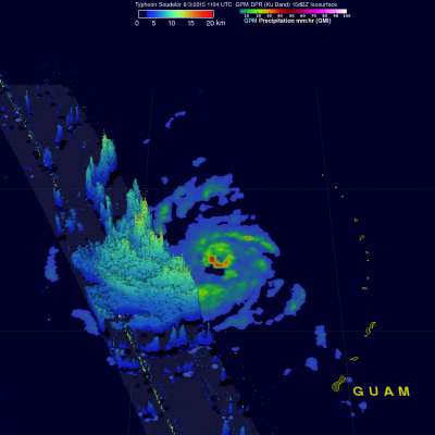
The GPM core observatory satellite flew almost directly over super typhoon Soudelor in the western Pacific Ocean on August 3, 2015 at 1104 UTC. At that time Super Typhoon Soudelor had winds of about 125kts (139 mph) and is predicted by the Joint Typhoon Warning Center (JTWC) to become even more powerful tomorrow while headed toward northern Taiwan. GPM's Microwave Imager (GMI) had a very good view of heavy rainfall associated with Soudelor. GMI showed that the super typhoon had rain falling at a rate of over 58 mm (2.3 inches) per hour in the southern side of Soudelor's well defined eye. Radar

TRMM Monitors Super Typhoon Francisco

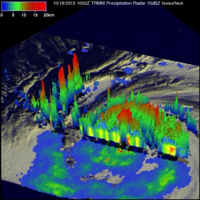
The sixth super typhoon of 2013 called Francisco developed in the Western Pacific Ocean on October 16, 2013. The image on the left was made from data collected as the TRMM satellite passed over on October 18, 2013 at 1002 UTC when super typhoon Francisco was located west-northwest of Guam. A rainfall analysis that used data from TRMM's Microwave Imager (TMI) and Precipitation Radar (PR) instruments is shown on the left overlaid on an enhanced infrared image from TRMM's Visible and InfraRed Scanner (VIRS). TRMM PR found that rain was falling at a rate of over 113 mm/hr (~4.5 inches) in powerful

Super Typhoon Soulik Forms in the Pacific

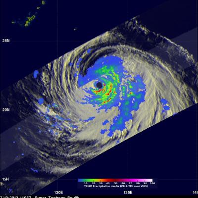
Typhoon Soulik became the first super typhoon of the year when the Joint Typhoon Warning Center estimated that it's sustained winds had increased to 125 knots (~144 mph), which is equivalent to a Category 4 hurricane on the US Saffir-Simpson scale, at 00 UTC on the 10th of July. Soulik began as a tropical depression on the 8th (local time) about 120 miles (~195 km) east of the Northern Mariana Islands and quickly became a typhoon 24 hours later after moving westward into the Philippine Sea where it continued to intensify. TRMM captured this latest image of Soulik in the central Philippine Sea