rainfall

GPM's First Global Rainfall and Snowfall Map
The Global Precipitation Measurement mission has produced its first global map of rainfall and snowfall. Like a lead violin tuning an orchestra, the GPM Core Observatory – launched one year ago on Feb. 27, 2014, as a collaboration between NASA and the Japan Aerospace Exploration Agency – acts as the standard to unify precipitation measurements from a network of 12 satellites. The result is NASA's Integrated Multi-satellite Retrievals for GPM data product, called IMERG, which combines all of these data from 12 satellites into a single, seamless map. The map covers more of the globe than any...
GPM Core Observatory in space with constellation satellites in background.
By Ellen Gray, NASA Goddard Space Flight Center Original www.nasa.gov Feature (published 4/12/13) This video, "Our Wet Wide World", provides an overview of the Global Precipitation Measurement Mission and its goals. Video Credit: Ryan Fitzgibbons As anyone who has ever been caught in a sudden and unexpected downpour knows, gaps still exist in our knowledge about the behavior and movement of precipitation, clouds and storms. An upcoming satellite mission from NASA and the Japanese Space Agency aims to fill in those gaps both in coverage and in scientists' understanding of precipitation. The...

2012 Western Atlantic Tropical Cyclone Rainfall Measured From Space

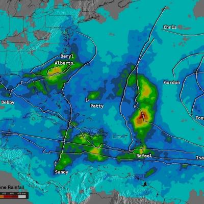
The TRMM satellite has now been making highly accurate measurements of rainfall from space for fifteen years. TRMM can be used to calibrate rainfall estimates from other additional satellites. Those Rainfall data (3B42) are routinely created and stored at the Goddard Space Flight Center. The TRMM-based, near-real time Multi-satellite Precipitation Analysis (TMPA) at the NASA Goddard Space Flight Center can be used to analyze rainfall over a wide portion of the globe. The TMPA analysis above shows the estimated amount of rain contributed by named tropical cyclones over the western Atlantic in
TRMM reign of rain screenshot
By Ellen Gray , NASA Goddard Space Flight Center Original www.nasa.gov Article (published 11/27/12) When it rains it pours, goes the saying, and for the last 15 years, the data on tropical rainfall have poured in. NASA's Tropical Rainfall Measuring Mission (TRMM) was launched on Nov. 27, 1997, and for the last decade and a half has enabled precipitation science that has had far reaching applications across the globe. TRMM Project Scientist Scott Braun looks back at the legacy of the Tropical Rainfall Measuring Mission and a few of the major scientific milestones the satellite has helped...

TRMM at 15: The Reign of Rain

Submitted by JacobAdmin on Tue, 11/27/2012
Video Embed

When it rains it pours, goes the saying, and for the last 15 years, the data on tropical rainfall have poured in. NASA's Tropical Rainfall Measuring Mission (TRMM) was launched on Nov. 27, 1997, and for the last decade and a half has enabled precipitation science that has had far reaching applications across the globe.

2011 a Wet Spring for the Central US

A combination of heavy rains and a large snow melt has put parts of the central US at risk for record flooding this spring with several locations along the Mississippi already at or near record levels. One likely culprit is La Nina. Despite the fact that the current La Nina appears to be winding down, it's effects in the atmosphere can persist for a while. Furthermore, although not every La Nina brings major flooding to the region, La Nina's are conducive for above-normal rainfall from East Texas and northern Louisiana up through Arkansas and the Tennessee and Ohio Valleys with below-normal