Peru

Peru's Deadly Rainfall Examined With NASA's GPM Data

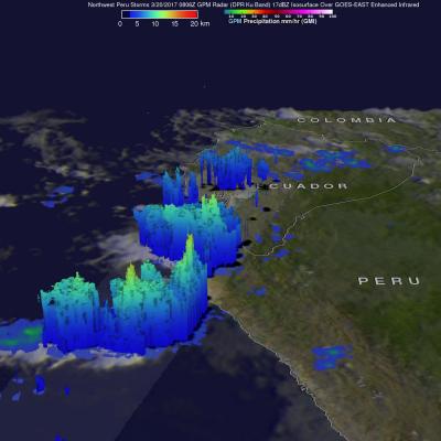
This year unusually heavy rainfall has caused extensive flooding and loss of life in Peru. Extreme flooding and frequent landslides that occurred this month have forced many from their homes. An El Niño like condition with warm ocean waters developed near Peru's coast. This extremely warm water off Peru's western coast has been blamed for promoting the development of these storms. Equatorial sea surface temperatures (SSTs) are about average elsewhere in the central and east central Pacific. This image shows the locations of storms that were dropping heavy rainfall over northwestern Peru when

Peru Flooding Rainfall Measured By IMERG

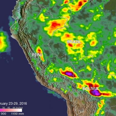
Heavy rainfall recently caused flooding, landslides and power cuts in some areas of Peru. Thousands were made homeless and at least two people were reportedly killed. Extremely heavy rainfall was reported in northern Peru on February 26 and February 27, 2016. In some areas the Peruvian army was sent to help those affected by flooding. The strong El Niño was partially blamed for the abnormally high rainfall in this area. NASA's Multi-satellitE Retrievals for GPM (IMERG) data collected from February 23-29, 2016 were used to estimate rainfall totals over this area of South America. The highest

Flooding in Eastern Peru, Dry in the West

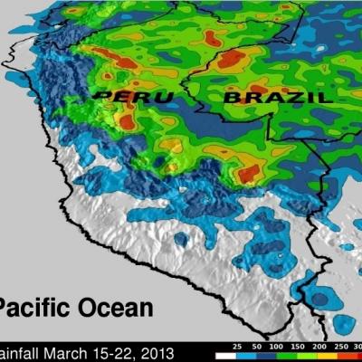
Hundreds of people in central Peru were recently flooded out of their homes. Rivers left their banks washing away buildings and highways while areas of Peru along the coast of the Pacific Ocean were relatively dry. Flooding from heavy rainfall in some areas of Peru was occurring at the end of the normal rainy season. Data from the TRMM satellite are used to calibrate rainfall data merged from various satellite sources. TRMM-based, near-real time Multi-satellite Precipitation Analyses (TMPA) at the NASA Goddard Space Flight Center are used to monitor rainfall over the global Tropics. TMPA