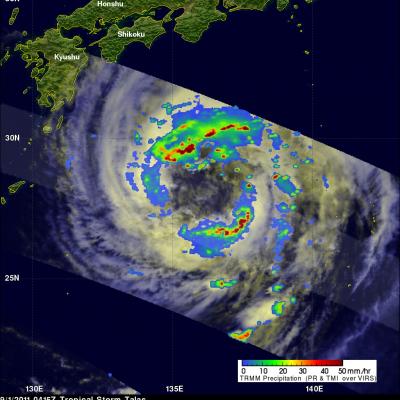
Tropical storm Talas was seen by the TRMM satellite approaching the main islands of Japan on 1 September 2011 at 0416UTC (~1:15 PM local time). This daylight TRMM pass shows that Talas had a very large nearly clear eye with large bands of intense thunderstorms located far from the storm's center. Talas is predicted travel over the main islands of japan in the next 36 hours.
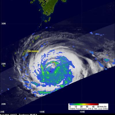
Typhoon Muifa had wind speeds of about 95 kts (~109 mph) when the TRMM satellite passed above on 3 August 2011 at 1307 UTC. Muifa is now predicted to pass just to the south of the Japanese Island of Okinawa. The southern tip of the Okinawa is expected to be in the right front quadrant of the typhoon on 5 August 2011 where the highest winds are normally located. TRMM's Microwave Imager (TMI) and Precipitation Radar (PR) data were used in the rainfall analysis shown on the right. See earlier TRMM information about typhoon Muifa.
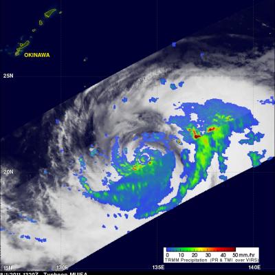
MUIFA was a super typhoon with wind speeds of 140 kts (~161 mph) on 30 August but wind speeds had dropped to about 110 kts (~127 mph) when it was seen by the TRMM satellite on 1 August 2011 at 1320 UTC. This TRMM orbit revealed that MUIFA had a double eyewall indicating that the typhoon was undergoing eyewall replacement with a larger eyewall shown forming farther out from a smaller inner eyewall. Muifa is expected to still be a powerful typhoon on 4 August 2011 as it passes directly over the Japanese island of Okinawa.
Typhoon Ma-On formed from an area of disturbed weather in the northwest Pacific halfway between Wake Island and the Northern Marianas on the 11th of July 2011. The system slowly developed and became a typhoon two days later on the 13th as it continued tracking westward. Ma-On then reached its maximum intensity on the 15th with sustained winds estimated at 115 knots (~132 mph), making it a Category 4 typhoon, before turning northward towards southern Japan. Ma-On began to weaken as it neared the southeast coast of Japan where it briefly made landfall in southern Tokushima Prefecture on the
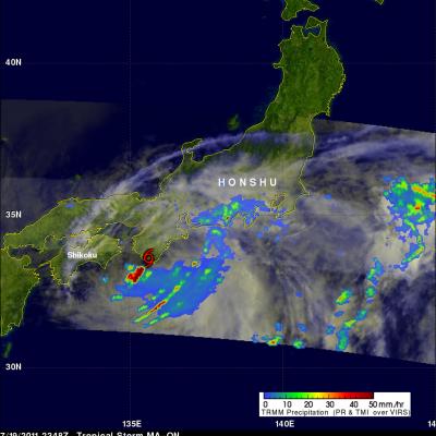
Typhoon MA-ON had weakened to a strong tropical storm with wind speeds of about 60 kts (69 mph) when the TRMM satellite again flew over on 19 July 2011 at 2348 UTC. The rainfall analysis above using TRMM's Microwave Imager (TMI) and Precipitation Radar (PR) data was overlaid on a daylight visible/infrared image from TRMM's Visible and InfraRed Scanner (VIRS) instrument. It reveals that although weaker MA-ON was dropping heavy rainfall over southern areas of the Japanese Island of Honshu. A red tropical storm symbol shows the location of MA-ON's center of circulation at that time. Click here to
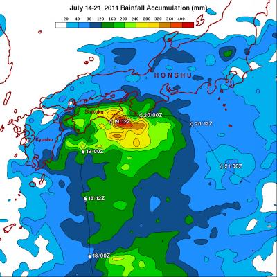
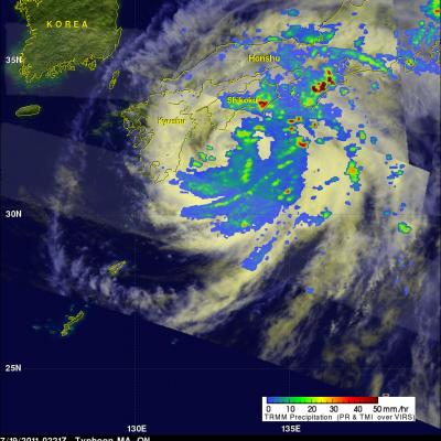
The TRMM satellite saw typhoon MA-ON on 18 July 2011 at 2306 UTC and again on 19 July 2011 at 0221 UTC. The rainfall analysis above used TRMM's Microwave Imager (TMI) and Precipitation Radar (PR) data from both orbits. It shows that bands of very heavy rainfall of over over 50 mm (~2 inches) were falling over both of the Japanese island of Shikoku and Honshu. At the time of the later TRMM orbit MA-ON's winds had weakened to about 67 kts (~77 mph) making it a category 1 typhoon on the Saffir/Simpson scale. MA-ON is expected to move toward the east-southeast and weaken as it continues to affect
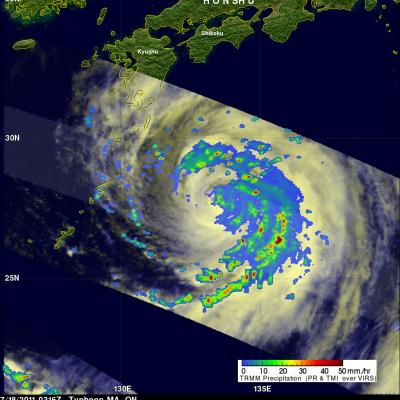
Typhoon MA-ON was a category 2 typhoon on the Saffir/Simpson scale with wind speeds of about 85 kts (~98 mph) when the TRMM satellite captured those data shown above on 18 July 2011 at 0316 UTC. MA-ON had weakened considerably from a very powerful category four typhoon with wind speeds of 115 kts (~132 mph) on 15 July 2011. TRMM's Microwave Imager (TMI) and Precipitation Radar (PR) data were used to produce the rainfall analysis shown above. This TRMM analysis shows that MA-ON still contained organized bands of very intense rainfall with the most intense precipitation located in the eastern
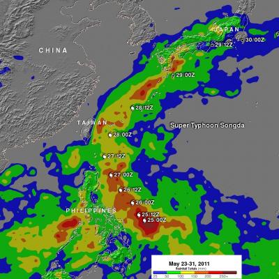
The TRMM-based, near-real time Multi-satellite Precipitation Analysis (TMPA) at the NASA Goddard Space Flight Center was used in the analysis above to show the total rainfall that occurred when super typhoon Songda was active in the western Pacific Ocean. TMPA rainfall totals are shown here for the period from 23 May to 31 May 2011. The rainfall analysis indicated that the highest rainfall totals of over 300mm (~11.8 inches) occurred in the Pacific east of the Philippines. The highest rainfall totals over land fell in the islands of southern Japan even though Songda had by then weakened to a