IMERG

GPM V05 Data Announcement and IMERG

The Precipitation Processing System has begun the transition to GPM Version 5 products. The satellite observations made in April 2017 will be the last observations to be included in Version 4 of the GPM data products, with one exception. Starting with observations made in May 2017, PPS will generate Version 5 GPM data products, again with one exception. The exception in both cases is that the PPS Realtime system will continue to generate the Version 4 Early and Late IMERG data products. Version 4 data products have been removed from the STORM data ordering system ( https://storm.pps.eosdis
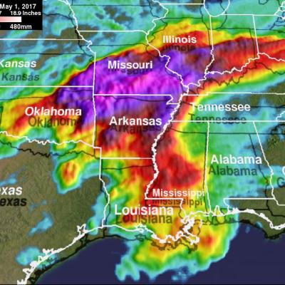
Extreme U.S. Rainfall Analyzed With IMERG Data JacobAdmin Mon, 05/01/2017
Tornadoes have accompanied severe weather over the United States almost daily during the past week. Severe storms spawned tornadoes from Texas and Oklahoma eastward through Mississippi. Upper Midwest states such Illinois, Indiana and Kentucky were also visited by tornadoes. Extreme rainfall caused deadly flooding in Missouri. More than a dozen people in the Midwest and South have been reported killed by tornadoes or flooding. The same weather system is spreading severe storms through East and Northeastern states today. NASA's Integrated Multi-satelliE Retrievals for GPM (IMERG) data were used

Change in IMERG early 2/5/2017-3/12/2017

During the initial setup up for V04 IMERG, an error was made in the configuration for running the EARLY version of IMERG. This affected the V04A early data from Feb 5 - March 12, 2017. This error caused the early and the late products to be identical. Given that the LATE product is the more accurate product this might not be an issue for many users. However, users who need a consistent approach in the early data will need to download IMERG early Feb 5-March 12, 2017 again. On April 12, 2017 at about 16:55 UTC Feb 5-Feb 28, 2017 files have been rerun and are available from their usual location

PPS Releases GPM IMERG V04 Final Data Products

PPS is announcing the release of GPM IMERG V04 Final products today, Wednesday March 22, 2017. Version 04 IMERG data is available on PPS's arthurhou ftp archive for the dates of March 2014 - July 2015. Processing will continue over the next several weeks until the data has been made available up to the present. This data can be found at: ftp://arthurhou.pps.eosdis.nasa.gov/gpmallversions/V04 Individual data orders, subsets or subscription orders can also be set up through PPS's STORM: https://storm.pps.eosdis.nasa.gov/storm/ Release notes and ATBD documentation for IMERG V04 can be found at

IMERG V04 Early and Late Online

The algorithm for the Integrated Multi-satellitE Retrievals for GPM (IMERG) Early and Late Runs has now been upgraded to Version 04. The transition to V04 began at 15 UTC on March 13 and both the early and the late products were back to their target latency by 01:00 UTC, March 14. The transition took longer than planned but the core IMERG version 04 products are now running automatically as the original V03. The product version is V04A and you will see this in the name of the IMERG HDF5 products. For IMERG late the V03 products have remained before February 05, 2017. For IMERG early V03

Upcoming IMERG version update to V04A

The algorithm for the Integrated Multi-satellitE Retrievals for GPM (IMERG) Early and Late Runs has now been upgraded to Version 04. The transition to V04 is planned to happen on Monday, March 13 by 15 UTC at PPS and the new data should start flowing down to the GES DISC as well. Access and data fields continue to be the same as for Version 03, except the version number is 04A. Initially, the data records begin on 5 February 2017 for the Late Run, and about 5 hours before the time when PPS begins processing after the switchover for the Early Run. Version 04 supersedes all prior IMERG versions
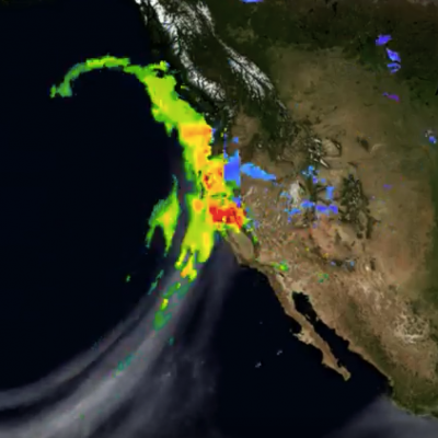
Atmospheric River Slams California
After more than four years of drought, Californians may wonder where the current rain is coming from. Using satellites, NASA scientists have a unique view of the sources of precipitation, and how it reaches the western United States. Rain is often carried by narrow tendrils of moisture called atmospheric rivers that occur all over the world, shown here in white. The atmospheric rivers that affect the western United States are known as the Pineapple Express because they transport water vapor from as far south as Hawaii to California. When the moisture reaches land, it is forced up over the...

Gauge Combination Error in 2016, Affects 3B42/43 and IMERG Final Run

We have discovered that the gauge analysis was erroneously omitted from the "production" 3B42/43 products starting with January 2016 due to issues with handling a change of data format. Thus, the production 3B42/43 are being re-computed. This does not affect the TMPA-RT suite of products, since no month-to-month gauge data are used. Note this issue also affects the current Version 3 IMERG Final Run products for January 2016. They are being recomputed as well. The current Version 3 IMERG Early and Late Runs are not affected. An update will be provided here when the corrected products are ready.

Jan. 2016 GPM IMERG and Jan.-Jun. 2016 TMPA 3B42/3B43 Data Products are Being Recalled and Replaced

UPDATE 9/27/16: January 2016 IMERG has been regenerated and posted. This was necessary due to an error that omitted the gauge analysis in the Final products. Also, 3B42/3B43 have been recomputed and posted. Let me know if you have any further questions. --- PPS has removed the January 2016 GPM IMERG and January through June 2016 3B42/3B43 TMPA products from our ftp archive: ftp://arthurhou.pps.eosdis.nasa.gov/ and STORM: https://storm.pps.eosdis.nasa.gov/storm/ The GPM science team discovered that the IMERG final products for Jan 2016 and the Jan-Jun 2016 TMPA 3B42/3B43 products for which we