heavy rainfall

Typhoon Dujuan Batters and Drenches Taiwan

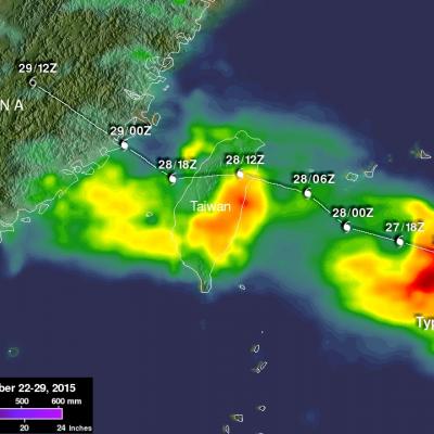
Typhoon Dujuan formed in the western Pacific Ocean northwest of Guam on September 21, 2015. Dujuan intensified to a super typhoon with winds of 125 kts (144 mph) on September 27, 2015 as it approached Taiwan. The island of Taiwan experienced extreme rainfall and damaging winds with the passage of typhoon Dujuan. The typhoon also caused hundreds of injuries and at least three deaths in Taiwan. After pounding Taiwan the typhoon started weakening before hitting China. Dujuan dropped light to moderate rainfall over a large area of coastal China while dissipating. A preliminary analysis of Rainfall

Wednesday September 9, 2015 Japan's Torrential Rain Measured With IMERG

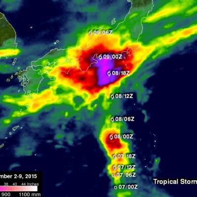
Over the past week Japan has experienced extreme rainfall that resulted in flooding, landslides and many injuries. A nearly stationary front that was already moving over Japan caused much of the rain but tropical storm ETAU also interacted with the front and magnified the scale of the deluge. Heavy rainfall led to the evacuation of over one million people. This rainfall analysis from space was generated using NASA's Integrated Multi-satellite Retrievals for GPM (IMERG) data. It shows rainfall total estimates for Japan during the seven day period from September 2-9, 2015 when Japan was getting

Deadly Typhoon Soudelor's Rainfall Analyzed

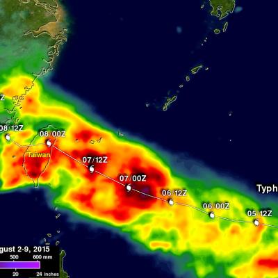
Soudelor formed in the middle of the Pacific Ocean well east of Guam on July 20, 2015. Soudelor became more powerful with peak intensity of about 155 kts (178 mph) reached on August 3, 2015 when the super typhoon was well east of Taiwan over the open waters of the Pacific Ocean. Soudelor's winds died down a little but rebounded to with over 100 kts (115 mph) before hitting Taiwan . Although Soudler was still a powerful typhoon when it hit land most deaths and destruction were caused by flooding and mudslides from heavy rainfall not from strong winds. The rugged terrain over typhoon amplified

IMERG Measures Record Rainfall From Hurricane Delores Remnants

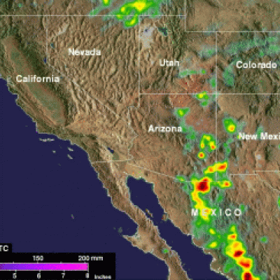
Moisture pumping into southern California and the Desert Southwest from the remnants of hurricane Dolores has caused record July rainfall. This rainfall may provide some drought relief to the state of California that has been in the grip of exceptional drought conditions. Heavy flooding caused an interstate 10 bridge collapse on Sunday July 19, 2015 forcing closure of this main roadway between Southern California and Phoenix, Arizona. Data from NASA's Integrated Multi-satellitE Retrievals for GPM (IMERG) were used to estimate the extreme amount of rain that fell during the past week in that

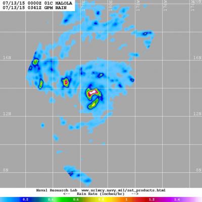
NASA Sees Heavy Rainfall in Tropical Storm Halola

The GPM satellite passed over Tropical Storm Halola in the northwestern Pacific Ocean and found heaviest rainfall occurring north of the center of circulation. Halola formed in the Central Pacific Ocean and moved into the Northwestern Pacific Ocean basin today, July 13. On July 13 at 1500 UTC (11 a.m. EDT) Tropical Storm Halola had maximum sustained winds near 60 knots (69 mph/111.1 kph). It was located near 14.5 North and 177.0 East, about 694 nautical miles (798 miles/1,285 km) east-southeast of Wake Island. Halola has tracked west-northwestward at 11 knots (12.6 mph/20.3 kph). The Global

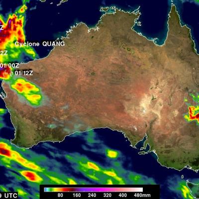
NASA IMERG Sees Australia's Bicoastal Rainfall

The rainfall accumulation analysis above was computed from data generated by the Integrated Multi-satellite Retrievals for GPM (IMERG) during the period from April 28 to May 3, 2015. During this period IMERG algorithms continuously merged and interpolated satellite passive microwave precipitation estimates and microwave-calibrated infrared (IR) satellite estimates over the entire globe. Rainfall from cyclone Quang fell over the west coast and a non-tropical system pounded the east coast of Australia simultaneously during the past weekend. Cyclone Quang formed in the South Indian Ocean

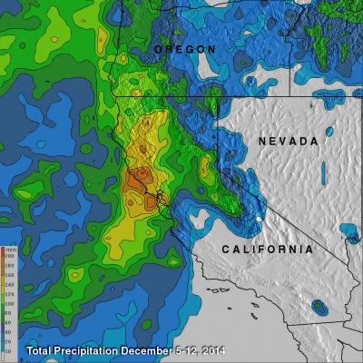
"Pineapple Express" Brings Heavy Rains, Flooding to U.S. West Coast

The West Coast, which has been suffering from a strong drought, is finally seeing some much needed relief as a steady stream of storms and rain pour into the coast from the Pacific. The rains began in Washington and Oregon and have now worked their way down the coast to southern California. The weather pattern responsible for all of the rain is known as the "Pineapple Express." The Pineapple Express is known as an atmospheric river. A large, slow-moving low pressure center off of the West Coast taps into tropical moisture originating around the Hawaiian Islands, which is then channeled

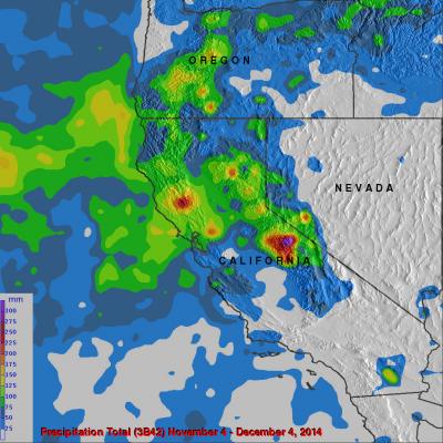
California's Rainfall Analyzed From Space

It has been very dry in the state of California for the past couple years. The lack of rain in 2013 and 2014 contributed to exceptional drought conditions in the state. Records were set over the past winter for the lowest winter snow packs recorded in a century. Rainfall produced by storms moving into California from the Pacific Ocean has recently brought some very temporary drought relief. Precipitation data (3B42) from various satellites such as TRMM and recently the GPM core observatory satellite have been collected, merged and archived at the Goddard Space Flight Center since 1998. The

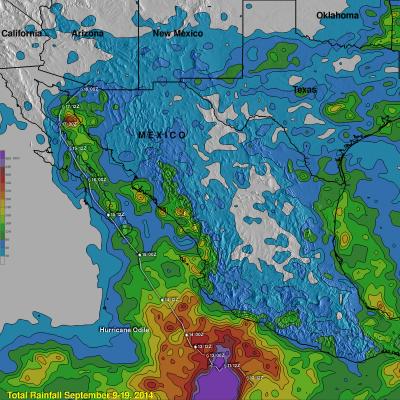
Hurricane Odile Rainfall Totals

During the past week hurricane Odile and remnants have produced heavy rainfall that caused dangerous flooding over the Baja California peninsula and the southwestern United States. Rainfall from Odile may be welcomed in the Southwest where some areas have been experiencing extreme to exceptional drought conditions. The Tropical Rainfall Measuring Mission or TRMM satellite was launched in November 1997 with the primary mission of measuring rainfall in the Tropics using a combination of passive microwave and active radar sensors. The rainfall analysis above was made using real-time TRMM Multi

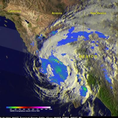
Baja California Battered And Drenched By Odile

Category three hurricane Odile caused widespread destruction after hitting Baja California on Sunday night. Odile had weakened to a tropical storm with winds of about 55 kts ( 63.3 mph) when the TRMM satellite flew over on September 16, 2014 at 0917 UTC (2:19 AM PDT). Odile was still well organized and TRMM's Precipitation Radar (PR) measured rain falling at a rate of almost 130 mm (5.1 inches) per hour northeast of the tropical storms's center of circulation. The tops of some strong thunderstorms over the Gulf Of California were reaching heights of 13km (8 miles) and returning radar