heavy rain

TRMM Sees Powerful Storm Over San Antonio

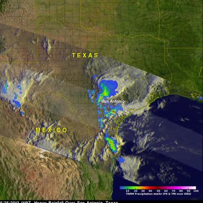
Three people died this past weekend from flooding in San Antonio, Texas. The TRMM satellite flew above Texas early Saturday morning at 1118 UTC (6:18 AM CDT) when powerful thunderstorms were drenching San Antonio. Data captured with this orbit by TRMM's Microwave Imager (TMI) and Precipitation Radar (PR) were used in this rainfall analysis. TRMM's Precipitation Radar (PR) instrument found rain falling at a rate of over 66 mm/hr (~2.5 inches) in one violent thunderstorm shown near the center of this image. This 3-D image shows a TRMM Precipitation Radar (PR) slice through storms over Texas. One

Heavy Weekend Rainfall Causes Flooding In Texas

Warm moist air from the Gulf of Mexico collided with a cold front resulting in extremely heavy rainfall in eastern Texas over the weekend. Rapid flooding resulted from reported rainfall of up to seven inches near Houston, Texas. The rainfall analysis was derived from the TRMM-based, near-real time Multi-satellite Precipitation Analysis (TMPA) at the NASA Goddard Space Flight Center. These rainfall data are derived from a TRMM-calibrated merger of various other satellite rainfall data. TMPA rainfall totals are shown here for the 3-day period from April 26-29, 2013. This analysis shows that

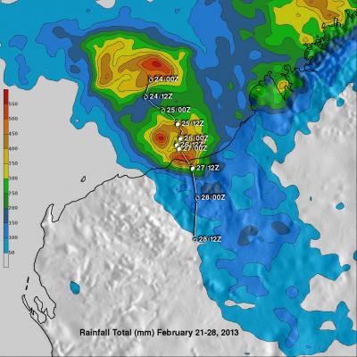
Tropical Cyclone Rusty's Flooding Rainfall

In addition to high winds tropical cyclone Rusty's heavy rainfall caused flooding in north-western Australia. The TRMM satellite's main purpose is the accurate measurement of tropical rainfall around the globe. TRMM is also used to calibrate rainfall estimates from other satellites. The TRMM-based, near-real time Multi-satellite Precipitation Analysis (TMPA) at the NASA Goddard Space Flight Center provides estimates of rainfall over the global Tropics. TMPA rainfall totals in association with tropical cyclone Rusty are shown for the period from February 21-28, 2013. Rusty's approximate 0000Z

Tropical Cyclone Batters and Drenches Samoan Islands

The TRMM satellite had an excellent view of tropical cyclone Evan on December 12, 2012 at 1704 UTC when it was battering the Samoan Islands with hurricane force winds. Evan is predicted by the Joint Typhoon Warning Center (JTWC) to intensify and have winds of 130kts (~150 mph) while remaining close to the islands. This wind speed would make it a strong Category 3 storm on the Saffir-Simpson Scale. A storm surge of 4.5 meters (14 feet) was reported along the Samoan coast. Evan's rainfall was analyzed using TRMM's Microwave Imager (TMI) and Precipitation Radar (PR) data. This analysis shows that

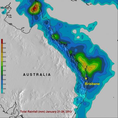
Extreme Rainfall Causes Flooding Over Eastern Australia

A large area of low pressure from the remnants of tropical storm Oswald has caused additional extremely heavy rainfall as it moved southward over eastern Australia. This deluge has caused flooding in areas from the Cape York Peninsula to the Queensland state capital, Brisbane. At least four deaths have been attributed to the high winds and flooding associated with this low pressure system. This image shows a TRMM calibrated Multi-satellite Precipitation Analysis (MPA) for the period from January 21-28, 2013. This analysis shows that tropical cyclone Oswald dumped over 600mm (~23.6 inches) of

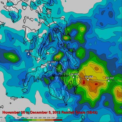
Typhoon Bopha's Heavy Rain Over Mindanao

High winds, flooding and landslides from heavy rains with typhoon Bopha have caused over 300 deaths in the southern Philippines. The Tropical Rainfall Measuring Mission (TRMM) satellite's primary mission is the of measurement of rainfall in the Tropics. The TRMM-based, near-real time Multi-satellite Precipitation Analysis (MPA) at the NASA Goddard Space Flight Center monitors rainfall over the global Tropics. MPA rainfall totals are shown here for the period from November 28 to December 5, 2012 when typhoon Bopha was moving through the southern Philippines. Typhoon Bopha's track is shown
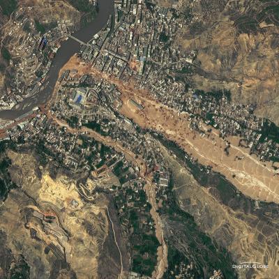
Aerial photo of 2010 landslide in Gansu, China
By Lisa-Natalie Anjozian , NASA Goddard Space Flight Center Original www.nasa.gov Press Release (published 11/27/12) A NASA study using TRMM satellite data revealed that the year 2010 was a particularly bad year for landslides around the world. Around midnight on August 8, 2010, a violent surge of loosened earth roared down mountain slopes and slammed into quietly sleeping neighborhoods in Zhouqu County in Gansu, China. The catastrophic mudslides—the deadliest in decades according to state media—buried some areas under as much as 23 feet (7 meters) of suffocating sludge. 1,765 people died...

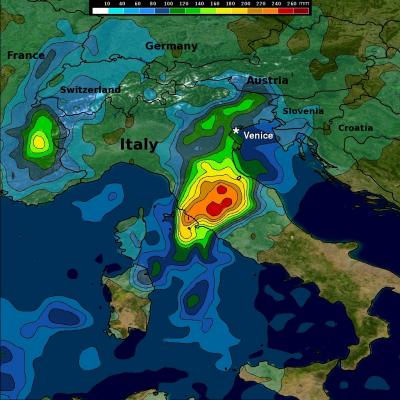
Heavy Rain Brings Flooding to Central and Northern Italy

Beginning this past weekend, parts of central and northern Italy received several days of heavy rain as an upper-level trough situated over western Europe down through the Iberian Peninsula in conjunction with a persistent area of low pressure at the surface over the northern coast of Africa brought a steady flow of warm, moist, unstable air northeastward across the country from the western Mediterranean. A stationary frontal boundary draped across the northern third of the Italian Peninsula provided the focus for showers and storms in that part of the country. The rains caused flooding in

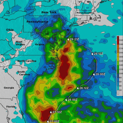
Deadly Super Storm Sandy's Rainfall

The reported death toll from hurricane Sandy's flooding and high winds has now reached above 120. Over 70 deaths were caused by Sandy in the Caribbean and recent reports bring the total to greater than 50 in the United States. Much of the recent deadly flooding along the northeastern United States coastlines was caused by super storm Sandy's storm surge. Strong winds from Sandy persistently pushed Atlantic ocean waters toward the coast. High tides that occurred at the same time also magnified the effects of the storm surge. Some flooding was also caused by long periods of heavy rainfall that
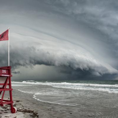
Shelf cloud approaching the beach.
Thank you to everyone who submitted photos to the first installment of our GPM Extreme Weather Photo Competition. We loved all of your entries and thoroughly appreciate your participation! The GPM Photo Competition Committee is happy to announce our top 5 picks. We’ll be sending the submitters NASA bags and GPM stickers. Please stay tuned for additional contests and activities. Ormond Shelf, by Jason Weingart Date and Location: May 15, 2012 Ormond Beach, Florida How this Photo Was Taken: “I'm a photography student at the University of Central Florida. I began chasing storms a little over three...