heavy rain

California's Drought Improving

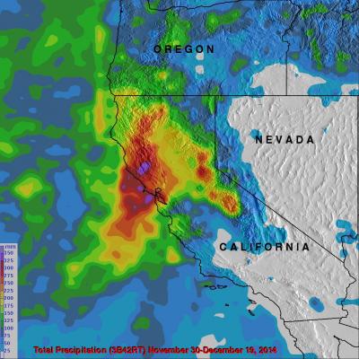
Waves of rainfall from Pacific Ocean storms show signs of improving the exceptional drought conditions that have been plaguing California. Starting on about November 30, 2014 storms frequently moved over California. A Multi-satellite Precipitation Analysis (MPA) using data (3B42) archived at near "real time" at the NASA Goddard Space Flight Center was used in the analysis. It indicates that northern California has had far more beneficial rainfall than southern California. This analysis shows that storms dropped over 350mm (almost 14 inches) in an area north of San Francisco. Southern

Typhoon Phanfone Batters And Soaks Japan

Phanfone was a powerful super typhoon with sustained wind speed estimated at 130 kts ( 150 mph) as it approached Japan but had weakened to a category one typhoon with sustained winds of about 70 kts (81 mph) as is passed near Tokyo. Phanfone's track and locations when the tropical cyclone was near Japan are shown overlaid in white. The TRMM- based, near-real time Multi-satellite Precipitation Analysis (TMPA) at the NASA Goddard Space Flight Center has been measuring the distribution of precipitation over the tropics. TMPA based rainfall totals are shown here for the period from September 28 to

Moisture From Norbert Spreads Heavy Rain Over Southwest

The TRMM satellite flew above the post-tropical cyclone remnants of former hurricane Norbert on September 8, 2014 at 0849 UTC (1:49 AM PDT). This image shows TRMM rainfall derived from the Microwave Imager (TMI) and Precipitation Radar (PR) instruments overlaid on a 0900 UTC GOES-EAST enhanced Infrared image. These data show that only a small amount of light to moderate rainfall was located around Norbert's center of circulation. This view shows that heavy rainfall was being produced over the southwestern United States. This 3-D image was made from TRMM Precipitation Radar (PR) data. It shows

Typhoon Matmo Drenches Taiwan

Typhoon Matmo hit eastern Taiwan at it's peak power with winds estimated at 85kts (about 98 mph). In addition to damaging winds Matmo produced very heavy rainfall while passing over central Taiwan. The TRMM-based, near-real time Multi-satellite Precipitation Analysis (TMPA) at the NASA Goddard Space Flight Center was used in this analysis to show rainfall totals for the period from July 17-24, 2014. It shows that rainfall totals greater than 400 mm (about 15.7 inches) soaked eastern Taiwan. Heavy rainfall also occurred yesterday over the Taiwan Strait. This band of heavy rainfall associated

Tropical Storm Neoguri Soaks Southern Japan

Once powerful typhoon Neoguri is dropping copious rainfall as it passes over southern Japan as a tropical storm. Heavy rainfall from Neoguri fell on land that was already soaked earlier this month by a slow moving seasonal frontal system. Flooding and mudslides from Neoguri have caused the deaths of three people in Japan this week. The TRMM Multi-Satellite Precipitation Analysis (TMPA), produced at Goddard Space Flight Center, combines the rainfall estimates generated by TRMM and other satellites (3B42). The analysis above shows a near-real time Multi-satellite Precipitation Analysis (TMPA)

A Week of Violent Weather And Heavy Rainfall

Over the past seven days stormy weather has spawned tornadoes and dropped extremely heavy rainfall in the Northern Plains and the Great Lakes states. This deluge has caused flooding in South Dakota, Minnesota, Iowa, Wisconsin and Illinios. There have been concerns about the Mississippi, Big Sioux and Rock River Rivers escaping their banks. For more than sixteen years rainfall has been monitored by the TRMM-based, near-real time Multi-satellite Precipitation Analysis (TMPA) . These products have been developed at the NASA Goddard Space Flight Center by the precipitation research team. (TMPA)

Heavy Rain & Tornadoes

Tornadoes killed two people yesterday in Pilger, Nebraska. Tornadoes were reported with violent weather that also hit the states of North Dakota, Iowa and Wisconsin. Heavy rainfall with this extreme weather was monitored with the TRMM-based, near-real time Multi-satellite Precipitation Analysis (TMPA) at the NASA Goddard Space Flight Center. An analysis of TMPA rainfall totals is shown here for the seven days from June 10-17, 2014. This analysis indicated that the highest rainfall totals for the period (light purple) were greater than 300 mm (about 11.8 inches) in northwestern Iowa. Locations

Extreme Rainfall Over Florida Panhandle

The TRMM satellite had a good view of recent extreme rainfall over the Florida panhandle that caused extensive flooding. TRMM Multi-satellite Precipitation Analysis (TMPA) data were used at NASA Goddard Space Flight Center to estimate total precipitation (mm) for the week from April 24 to May 1,2014. Rainfall totals of up to 620 mm (about 25 inches) were analyzed in the Pensacola, Florida area. The continuous "training" of heavy rainfall into the area was viewed several times by the TRMM satellite. The TRMM satellite flew above the area on April 30, 2014 at 0128 UTC (9:28 PM EDT April 29, 2014
Super Typhoon Haiyan Hits the Philippines
Super typhoon Haiyan, equivalent to a Category 5 hurricane on the US Saffir-Simpson scale, struck the central Philippines municipality of Guiuan at the southern tip of the province of Eastern Samar early Friday morning at 20:45 UTC (4:45 am local time) as an extremely powerful super typhoon, perhaps the strongest ever recorded at landfall, with sustained winds estimated at 195 mph (315 kph) by the Joint Typhoon Warning Center. Previously, Hurricane Camille, which struck the northern Gulf Coast in 1969, held the record with 190 mph sustained winds at landfall. After striking Samar, Haiyan...

TRMM Sees Heavy Rain Over Taiwan

The TRMM satellite flew directly above western Taiwan on August 28, 2013 at 2108 UTC when tropical storm Kong-Rey was dropping enormous amounts of rain. Flooding from torrential rainfall with totals of over 500mm (~19.7 inches) have been reported in western Taiwan. This rainfall analysis from TRMM's Microwave Imager (TMI) and Precipitation Radar (PR) instruments revealed that precipitation was falling at a rate of over 205mm/hr (~8 inches) in intense bands of rain over southwestern Taiwan. Tropical storm Kong-Rey's location when TRMM flew over is shown with a red symbol. This TRMM orbit also