Harvey

Intense Hurricanes Seen From Space
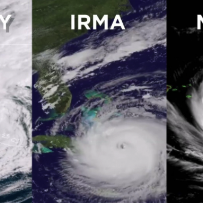
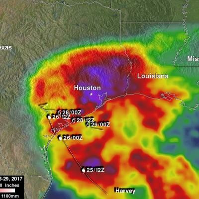
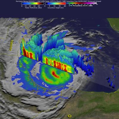
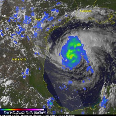
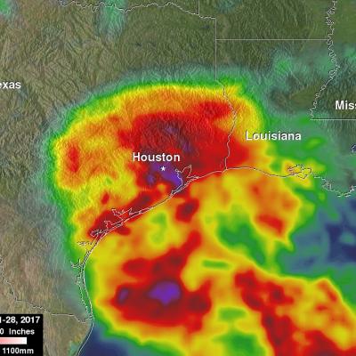
In 2017, we have seen four Atlantic storms rapidly intensify with three of those storms - Hurricane Harvey, Irma and Maria - making landfall. When hurricanes intensify a large amount in a short period, scientists call this process rapid intensification. This is the hardest aspect of a storm to forecast and it can be most critical to people's lives. While any hurricane can threaten lives and cause damage with storm surges, floods, and extreme winds, a rapidly intensifying hurricane can greatly increase these risks while giving populations limited time to prepare and evacuate.
GPM Captures Hurricane Harvey's Rainfall
Music: "Whirlpool," Michael Jan Levine, Killer Tracks The Global Precipitation Measurement (GPM) Core Observatory captured these images of Hurricane Harvey at 11:45 UTC and 21:25 UTC on the 27th of August nearly two days after the storm made landfall as it was meandering slowly southeast at just 2 mph (~4 kph) near Victoria, Texas west of Houston. The image shows rain rates derived from GPM's GMI microwave imager (outer swath) and dual-frequency precipitation radar or DPR (inner swath) overlaid on enhanced visible/infrared data from the GOES-East satellite. Harvey's cyclonic circulation is...

NASA's IMERG Shows Rainfall Accumulation Along Harvey's Track

Total rainfall estimates from NASA's Integrated Multi-satelliE Retrievals for GPM (IMERG) data are shown here for the period from August 23-29, 2017. During this period hurricane Harvey dropped heavy rainfall as it moved through the Gulf Of Mexico and stalled over Texas. It has been reported that Harvey dropped over 40 inches (1016 mm) of rain over southeastern Texas during this period. Hurricane Harvey's locations and track are shown here overlaid in white IMERG Data are produced using data from the satellites in the GPM Constellation, and is calibrated with measurements from the GPM Core
Harvey Hits Texas, Unleashes Major Flooding
Despite its earlier demise, after rejuvinating over the warm waters of the Gulf of Mexico, Hurricane Harvey has become a major weather maker as it unleashes historical flooding over parts of coastal Texas. Harvey began on the 17th of August as a weak tropical storm about 250 miles (~400 km) east of Barbados in the Leeward Islands. Over the next two days, Harvey continued moving steadily westward passing through the Leeward Islands as a still weak tropical storm and entered into the east central Caribbean. On the 19th, Harvey succumbed to the effects of northeasterly wind shear over the central...

GPM's Radar Measures Intense Rain In Hurricane Harvey

Hurricane Harvey's has continued to intensify today as it moves toward the Texas coast. Bands of rain from the hurricane were affecting the Gulf coast from Louisiana to southeastern Texas. The Global Precipitation Measurement (GPM) mission core observatory satellite had another look at hurricane Harvey on August 25, at 7:50 AM CDT (1150 UTC) as it was menacing the Texas gulf coast. GPM's Dual-Frequency Precipitation Radar (DPR) instrument scanned precipitation within powerful storms wrapping around the eastern side of the hurricane. DPR found that intense storms in that area were dropping rain

GPM Observes Intensifying Hurricane Harvey's Rainfall

UPDATE: View the latest GPM overpass from 8/25/17 1141 UTC using the STORM Event Viewer: https://storm.pps.eosdis.nasa.gov/storm/cesium/EventViewer.html?positio… Hurricane Harvey has continued to intensify after regenerating in the southwestern Gulf of Mexico on Wednesday. Harvey's intensification has been aided by moving through an environment that includes low vertical wind shear and the warm waters in the Gulf Of Mexico. The Global Precipitation Mission (GPM) core observatory satellite

Reviving Tropical Storm Harvey's Remnants Observed By GPM

The National Hurricane Center (NHC) upgraded the remnants of tropical storm Harvey to a tropical Depression on August 23, 2017 at 10:00 AM CDT (1500 UTC). Harvey became better organized and was revived after moving from Mexico's Yucatan Peninsula into the Bay of Campeche. The warm waters of the Gulf of Mexico and favorable vertical wind shear promoted the regeneration of the tropical cyclone. The GPM core observatory satellite flew over the regenerating tropical cyclone on August 23, 2017 at 6:58 AM CDT (1158 UTC). Data collected by GPM's Microwave Imager (GMI) and Dual-Frequency Precipitation

GPM Sees New Tropical Storm Harvey

The National Hurricane Center (NHC) upgraded a tropical disturbance that they were monitoring east of the Lesser Antilles to Tropical storm Harvey on August 17, 2017 at 5:00 PM EDT (2100 UTC). The GPM core observatory satellite flew over newly designated tropical storm Harvey on August 17, 2017 at 6:21 PM EDT (2221 UTC). Easterly vertical wind shear was causing the strongest convection to be pushed to the west of the tropical storm's center of circulation. GPM's Microwave Imager and Dual-Frequency Precipitation Radar (DPR) found that some of these strong convective storms were dropping very

Harvey Dropped Heavy Rain In Some Areas

Tropical storm Harvey is dissipating inland over southern Mexico while hurricane Irene is drenching the island of Puerto Rico. Harvey's track is shown on the rainfall analysis above with appropriate tropical cyclone symbols in white. The TRMM-based, near-real time Multi-satellite Precipitation Analysis (TMPA) at the NASA Goddard Space Flight Center provides quantitative rainfall estimates over the global tropics. An analysis of TMPA rainfall totals for the period August 15-22, 2011 is shown for the area transited by tropical storm Harvey. The highest rainfall total associated with Harvey was