Haiti

GPM Examines Hurricane Irma
The GPM core observatory satellite had an exceptional view of hurricane Irma's eye when it flew above it on September 5, 2017 at 12:52 PM AST (1652 UTC). This visualization shows a rainfall analysis that was derived from GPM's Microwave Imager (GMI) and Dual-Frequency Precipitation Radar (DPR) data. Irma was approaching the Leeward Islands with maximum sustained winds of about 178 mph (155 kts). This made Irma a dangerous category five hurricane on the Saffir-Simpson hurricane wind scale. Intense rainfall is shown within Irma's nearly circular eye. This 3-D cross-section through Irma's eye was...

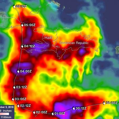
Deadly Hurricane Matthew's Total Rainfall

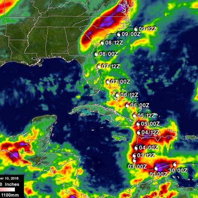
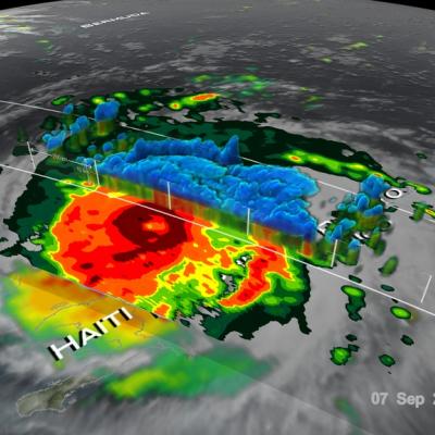
Hurricane Matthew devastated western Haiti and killed over 1,000 people. Matthew also took the lives of at least 37 deaths in the United States with 18 deaths occurring in the state of North Carolina. Flooding is still widespread in North Carolina. Some rivers in North Carolina such as the Tar and the Neuse are still rising. This rainfall analysis was accomplished using data from NASA's Integrated Multi-satelliE Retrievals for GPM (IMERG). IMERG is a unified U.S. algorithm that provides a multi-satellite precipitation product. IMERG is run twice in near-real time with the “Early” multi

Matthew Brings Heavy Rains, Destruction to Parts of the Northern Caribbean

Matthew began as a fairly impressive tropical wave that emerged off of the coast of Africa on the 23rd of September but had to make its way all the way across the Central Atlantic before finally organizing into a tropical storm on the morning of the 28th while passing through the Windward Islands. Matthew then slowly but steadily intensified into a minimal hurricane by the early afternoon of the following day as it continued to track westward through the central eastern Caribbean. The next day, September 30th, Matthew underwent a period of rapid intensification; its winds increased in
GPM Sees Hurricane Matthew Nearing Florida
UPDATE 10/6/16: NASA's Global Precipitation Measurement mission or GPM core observatory satellite flew over Hurricane Matthew several times as the category 4 storm headed toward Florida. The GPM Core Observatory carries two instruments that show the location and intensity of rain and snow, which defines a crucial part of the storm structure – and how it will behave. The GPM Microwave Imager sees through the tops of clouds to observe how much and where precipitation occurs, and the Dual-frequency Precipitation Radar observes precise details of precipitation in 3-dimensions. This data...

Dominican Republic And Haiti Hit By Deadly Floods

It has been reported that spring floods with mudslides have resulted in the death of at least 9 people and forced 11,000 people to flee their homes in the Dominican Republic. Data from the TRMM satellite are used to calibrate rainfall data merged from various satellite sources. TRMM-based, near-real time Multi-satellite Precipitation Analyses (TMPA) at the NASA Goddard Space Flight Center are used to monitor rainfall over the global Tropics. TMPA rainfall estimates are shown above for the week from April 19 to April 26, 2012. This analysis shows that extreme rainfall (shown in dark red)

Persistant, Heavy Rains lead to Flooding in Haiti

A trough of low pressure draped across the Greater Antilles together with a persistent area of broad low pressure located in the western Caribbean combined to bring a weeks worth of steady and often heavy rains to the region. This resulted in flooding across portions of Haiti, Jamaica, the Dominican Republic, Puerto Rico, and the Virgin Islands. The Tropical Rainfall Measuring Mission satellite, which was launched in November of 1997 uses both passive and active sensors to measure rainfall over the global tropics from space. To increase the effective coverage, TRMM can be used to calibrate