GMI
V04 Processing processing of GMI GPROF retrievals began at 11:20 UTC, May 2. Please note the the GPM Near-realtime (NRT) subsystem began to run the V04A GPROF precipitation retrieval effective 11:20UTC, May 2, 2016. Information about changes in the version can be found in the document GMI.V4.Release.Notes_05.01.2016.pdf that is located in directory /NRTPUB/V4ReleaseInfo The biggest change in the retrieval is the use of an a-priori database constructed from Combined and KU actual mission retrievals rather than the pre-launch composite databases. Partner radiometer (both conincally scanning and
IMERG Early/Late Run Precipitation Anomalies
Beginning on April 6, anomalies in the input SSMIS F17 precipitation estimates were detected in the IMERG Early and Late runs. These anomalies manifest as episodic “swath shaped” areas of high precipitation over land which appear to affect most orbits to some degree. The root cause is degradation in the 37 GHz V polarization channel. On April 13 the issue was somewhat mitigated but we continue to monitor the situation. Please let us know if you detect these (or other anomalies) in the IMERG Early and Late Runs after April 13.
V04 Processing for GPM Near-Realtime (NRT) is Scheduled to Begin
JacobAdmin
Tue, 03/01/2016
Late on March 2, 2016, the GPM NRT system will begin using V04 algorithms for: Level 1B GMI Level 1C GMI Level 1 Radar Level 2 Radar Level 2 Combined V04 is the first version that uses GPM as the calibrator for the constellation rather than TRMM. The GPROF database is built using the combined observations. GMI is extremely well calibrated and the brightness temperatures in 1B and 1C are an important improvement over those in V03. V04 also made improved retrievals in the Ku, Ka, and DPR Level 2 products. Combined has also made retrieval improvements in this version. GPROF the algorithm used for
Positional Algorithm Issue with GMI 85GHz
One of our scientists noticed that the 85GHz H and V channels have missing values in ascending passes just south of 20 deg S. In that region it appears consistently since 10:45UTC which is the earliest we checked. The other channels seem fine. The counts for the 85GHz channels appear to be fine as is the geolocation. However both the 1B and 1 Base files have the missing values in that area. We are checking what is causing the algorithm to list the values as missing. Please keep this in mind when using those channels.
Delay in Some GMI and Combined
Starting at 16:33 UTC July 6 a filled log directory led to sh commands failing on redirecting logs to be created in that directory. A typo in the cleanup routine failed to clean our all the files after the normal 4 days. As a result they have been accumulating since the beginning of the mission. It is unexpected that the sh failed when it could not redirect anymore. All data products that failed have been created and put in the appropriate directories. However, this will mean a failure in the data latency requirements for some of the GMI L1B and GPROF and a few combined products.
Initial IMERG Products Released
PPS is re-releasing the first public version IMERG products The Integrated Multi-satellitE Retrievals for GPM (IMERG) merges precipitation estimates from passive microwave sensors, geo-IR, and monthly surface precipitation gauge analysis data (where available) to provide half-hourly and monthly precipitation estimates and related fields on a 0.1° lat./long. grid over the domain 60°N-S. The current period of record is mid-March 2014 to the present (delayed by about 3 months) .Please refer to the IMERG Release notes , the technical IMERG document and the IMERG Algorithm Theoretical Basis
Tropical Depression Mekkhala Organizes
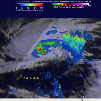
Tropical Depression 01W, in the western Pacific Ocean, has been given the name Mekkhala. The tropical cyclone has become much better organized and the Joint Typhoon Warning Center (JTWC) predicts that tropical storm Mekkhala will affect the eastern Philippines in a few days. The GPM (core satellite) flew above Mekkhala on January 14, 2015 at 1043 UTC. GPM's Microwave Imager (GMI) instrument observed rain falling at a rate of over 71.63 mm (about 2.8 inches) per hour in intense convective storms near the tropical cyclone's center. This 3-D view was derived from data collected by GPM's Radar (Ku
GMI Production Halted for Deep Space Calibration
On December 8, 2014 and December 10, 2014 the GPM MOC will conduct deep space calibrations maneuvers that will assist in physically verifying GMI calibration changes and also help in further characterization of the GMI instrument itself. Special processing is required for the data collected during the DSC. Therefore, PPS production of Standard GMI products will be halted on Dec 8 at 20:30 UTC. Processing will resume during normal business hours on Dec 9. On December 10, the maneuver is scheduled to begin at 12:00 UTC. Depending on the arrival of the DSC data processing may again be halted


