Gert

GPM Examines Hurricane Gert's Rainfall

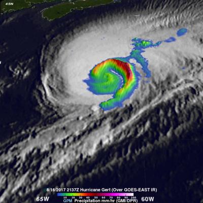
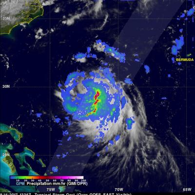
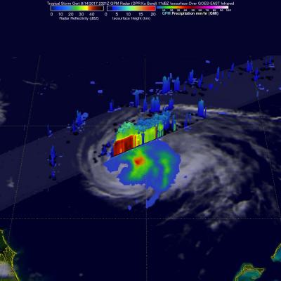
The GPM core observatory satellite provided rainfall information about hurricane Gert on August 16, 2017 at 5:37 PM EDT (2137 UTC). At that time Gert was a strong category two hurricane with maximum sustained winds of about 93.5 mph (85 kts). Data from GPM's Microwave Imager (GMI) instrument showed that rain was still falling at a rate of more than 2.94 inches (74.7 mm) per hour in a powerful band of storms spiraling around Gert's eastern side. With that pass GPM's Dual-Frequency Precipitation Radar (DPR) had a limited encounter with hurricane Gert. DPR did find that rain in storms on the

More Organized Tropical Storm Gert's Rainfall Examined by GPM

The GPM core observatory satellite passed above tropical storm Gert on August 14, 2017 at 9:36 EDT (1336 UTC) when winds had reached about 57.5 mph (50 kts). Data collected by GPM's Microwave Imager (GMI) and Dual-Frequency Precipitation Radar (DPR) instruments were used to show the coverage and the intensity of rainfall arround tropical storm Gert. The area covered by GPM's radar swath (shown in lighter shades) revealed that the most intense rainfall, measuring greater than 3.5 inches (90 mm) per hour, was located in bands of rain on the eastern side of the storm. This GPM pass was mentioned

GPM Sees Gert Approaching Hurricane Intensity

Tropical storm Gert was upgraded to a Hurricane on 1100 PM EDT Monday August 14, 2017 at 11:00 PM (August 15, 2017 0300 UTC). The GPM core observatory satellite flew over the intensifying tropical storm on August 14, 2017 at 7:21 PM EDT (2321 UTC). With winds of about 69 mph (60 kts) Gert was getting close to hurricane intensity. Data collected by GPM's Microwave Imager (GMI) and Dual-Frequency Precipitation Radar (DPR) instruments showed heavy rainfall south of Gert's partial eye. GMI showed that rain was falling at a rate of over 1.6 inches (40 mm) in that area. GPM's Radar scanned through

Tropical Storm Gert Dissipating

The TRMM satellite showed that tropical Storm Gert still contained a few potent thunderstorms when it traveled directly over head on 16 August 2011 at 0005 UTC. As predicted by the National Hurricane Center (NHC) Gert passed to the east of Bermuda. Gert is now expected to accelerate movement toward the northeast and dissipate in the cold waters of the Atlantic Ocean.

Tropical Storm Gert

Tropical Storm Gert became the seventh named tropical cyclone in the Atlantic Ocean basin on Sunday August 14, 2011 at 1800 UTC ( 2 PM EDT). Gert was located southeast of Bermuda and appeared small but well organized when the TRMM satellite flew over on 15 August 2011 at 0101 UTC. A rainfall analysis from TRMM's Microwave Imager (TMI) shows a comma shaped area of moderate to heavy rainfall wrapping around the center of the small storm. The National Hurricane Center (NHC) expects Gert to intensify slightly while passing just to the east of Bermuda. Click here to see earlier TRMM information