flooding

Harvey Hits Texas, Unleashes Major Flooding
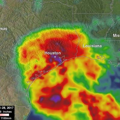
Despite its earlier demise, after rejuvinating over the warm waters of the Gulf of Mexico, Hurricane Harvey has become a major weather maker as it unleashes historical flooding over parts of coastal Texas. Harvey began on the 17th of August as a weak tropical storm about 250 miles (~400 km) east of Barbados in the Leeward Islands. Over the next two days, Harvey continued moving steadily westward passing through the Leeward Islands as a still weak tropical storm and entered into the east central Caribbean. On the 19th, Harvey succumbed to the effects of northeasterly wind shear over the central...

GPM's Radar Measures Intense Rain In Hurricane Harvey

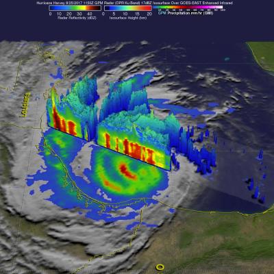
Hurricane Harvey's has continued to intensify today as it moves toward the Texas coast. Bands of rain from the hurricane were affecting the Gulf coast from Louisiana to southeastern Texas. The Global Precipitation Measurement (GPM) mission core observatory satellite had another look at hurricane Harvey on August 25, at 7:50 AM CDT (1150 UTC) as it was menacing the Texas gulf coast. GPM's Dual-Frequency Precipitation Radar (DPR) instrument scanned precipitation within powerful storms wrapping around the eastern side of the hurricane. DPR found that intense storms in that area were dropping rain

Deadly Southern Asia Flooding Rainfall Measured By NASA's IMERG

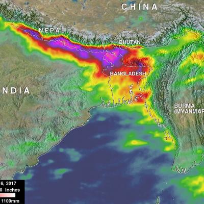
Deaths of over 250 people have resulted from extremely heavy monsoon rainfall in parts of northern India, Bangladesh and Nepal. The death toll from flooding and landslides is expected to continue increasing. Heavy monsoon rainfall is normal in southern Asia this time of year but precipitation totals this year are higher than expected. Recent heavy rainfall is also causing the Brahmaputra and Ganges Rivers rivers to continue rising. This rainfall analysis over southern Asia was created using IMERG real time data covering the period from August 10-16, 2017. Total rainfall IMERG estimates of over

New Zealand's Extreme Rainfall Examined With IMERG

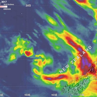
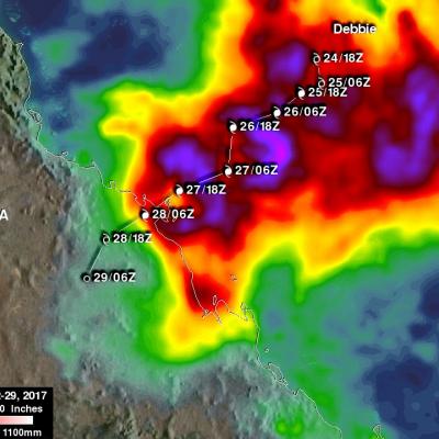
Two extra-tropical cyclones recently dropped very heavy rain over New Zealand. Tropical cyclone Debbie dumped extreme amounts of rain over the northeastern coast of Australia when it hit the Queensland coast on March 28, 2017. After drenching northeastern Australia Extra-tropical Cyclone Debbie transported a river of water over New Zealand last week. Debbie's remnants dropped heavy rainfall that caused widespread flooding near the Bay of Plenty on New Zealand's northeastern coast. Thousands of residents needed to be evacuated with extra-tropical cyclone Debbie. This week extra-tropical cyclone
GPM Measures Tropical Cyclone Debbie
Tropical cyclone Debbie formed in the Coral Sea northeast of Australia om March 24, 2017. Debbie intensified and had hurricane force wind speeds within a day of formation. While headed toward northeastern Australia Debbie reached it's maximum sustained wind speeds estimated at over 100 kts (115 mph) on March 27, 2017 (UTC). Tropical cyclone Debbie came ashore on March 28th and brought destructive winds and extremely heavy rain to northeastern Australia. It was reported that heavy rainfall caused flash flooding that cut off a coastal town and covered several roads in Queensland. The GPM...

Mudslides & Flooding Produced By Extreme Rainfall Over Southern California

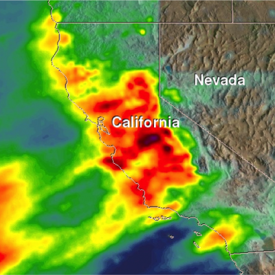
It is sunny in southern California today but recent unusually heavy rainfall led to rock slides, mudslides and flooding in that part of the country. Rainfall of almost 4 inches (101.6 mm) in one day was reported in Long Beach, California. Some highways in the area were flooded due to intense downpours. Rainfall since the fall of 2016 has improved drought conditions over northern California but Southern California has been slower to improve because of the exceptional rainfall deficit in that area. NASA's Integrated Multi-satellitE Retrievals for GPM (IMERG) were used to estimate the total

Pineapple Express Delivers Heavy Rains, Flooding, Drought Relief to California

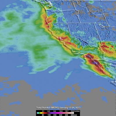
An atmospheric river (“Pineapple Express”) delivered over 5 inches of rainfall in parts of California during January 3-10, 2017 (bottom) as viewed by GPM’s IMERG data. California, which has long been suffering through a strong, multi-year drought, is finally beginning to see some much needed relief as a result of a recent series of storms that are part of a weather pattern known as the “Pineapple Express.” The Pineapple Express is known as an atmospheric river. A large, slow-moving low pressure center off of the West Coast taps into tropical moisture originating from as far south as the
Deadly Hurricane Matthew's Total Rainfall JacobAdmin Wed, 10/12/2016
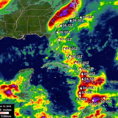
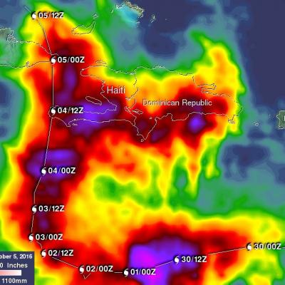
Hurricane Matthew devastated western Haiti and killed over 1,000 people. Matthew also took the lives of at least 37 deaths in the United States with 18 deaths occurring in the state of North Carolina. Flooding is still widespread in North Carolina. Some rivers in North Carolina such as the Tar and the Neuse are still rising. This rainfall analysis was accomplished using data from NASA's Integrated Multi-satelliE Retrievals for GPM (IMERG). IMERG is a unified U.S. algorithm that provides a multi-satellite precipitation product. IMERG is run twice in near-real time with the “Early” multi

Matthew Brings Heavy Rains, Destruction to Parts of the Northern Caribbean

Matthew began as a fairly impressive tropical wave that emerged off of the coast of Africa on the 23rd of September but had to make its way all the way across the Central Atlantic before finally organizing into a tropical storm on the morning of the 28th while passing through the Windward Islands. Matthew then slowly but steadily intensified into a minimal hurricane by the early afternoon of the following day as it continued to track westward through the central eastern Caribbean. The next day, September 30th, Matthew underwent a period of rapid intensification; its winds increased in
GPM Provides a Closer Look at the Louisiana Floods
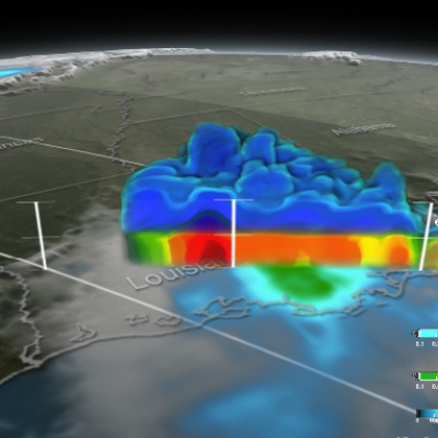
Twice on August 12, 2016 GPM flew over a massive rainstorm that flooded large portions of Louisiana. The flooding was some of the worst ever in the state, resulting in a state of emergency. Tens of thousands of people were evacuated from their homes in the wake of this unprecedented event. Throughout the course of August 12 (UTC) GPM captured the internal structure of the storm twice and GPM IMERG measured the rainfall accumulation on the ground. NASA's GPM satellite is designed to measure rainfall using both passive microwave (GMI) and radar (DPR) instruments. DPR can observe 3D structures of...