Dominican Republic

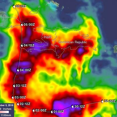
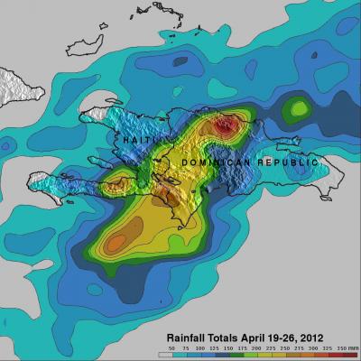
Deadly Tropical Rainfall Examined by IMERG

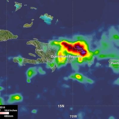
Scattered to numerous showers and scattered thunderstorms have occurred over Hispaniola during the past week. Slow moving frontal systems draped over Hispaniola and a tropical wave recently caused heavy rainfall that led to wide spread flooding over the northern Dominican Republic. Over 20,000 people have been displaced from their homes and at least five deaths have been reported. A broad area of low pressure (90L) in the southwestern Caribbean is also being monitored for possible tropical cyclone development by the National Hurricane Center (NHC). Very warm sea surface temperatures and upper

Matthew Brings Heavy Rains, Destruction to Parts of the Northern Caribbean

Matthew began as a fairly impressive tropical wave that emerged off of the coast of Africa on the 23rd of September but had to make its way all the way across the Central Atlantic before finally organizing into a tropical storm on the morning of the 28th while passing through the Windward Islands. Matthew then slowly but steadily intensified into a minimal hurricane by the early afternoon of the following day as it continued to track westward through the central eastern Caribbean. The next day, September 30th, Matthew underwent a period of rapid intensification; its winds increased in

GPM Examines Threatening Tropical Disturbance

On August 25, 2016 at 0716 UTC (3:16 AM EDT) the GPM core observatory satellite had an excellent look at an area of low pressure associated with a tropical wave moving past the northern Dominican Republic. The National Hurricane Center (NHC) has been monitoring this area of disturbed weather for potential development into a tropical cyclone. This low is predicted by the NHC to produce heavy rainfall as it continues moving toward the northeast. The development of a tropical storm or hurricane moving in this direction could pose future danger to the Bahamas and the southeastern United States

GPM Measures Deadly Flooding Rainfall

Over the past week extreme rainfall caused flooding that resulted in the deaths of four in Haiti and the evacuation of over 2500 people in the Dominican Republic. The GPM core observatory satellite saw a line of heavy rainfall on the eastern side of the Dominican Republic when it flew over on May 8, 2016 at 0428 UTC. GPM's Microwave Imager (GMI) and Dual-Frequency Precipitation Radar (DPR) instruments collected data that were used to estimate rainfall. This precipitation is shown on a top-down satellite view. Powerful storms were measured dropping rain at a rate of almost 300 mm (11.8 inches)

Tropical Depression Gabrielle

The National Hurricane Center (NHC) upgraded a low pressure center south of Puerto Rico to tropical depression number seven on September 4, 2013 at 2100 UTC (5:00 PM EDT). The tropical depression was then again upgraded to tropical storm Gabrielle on September 5, 2013 at 0300 UTC (11 PM EDT). Gabrielle was subsequently downgraded to a tropical depression at 1500 UTC (11 AM EDT). The TRMM satellite's Microwave Imager (TMI) had a fairly good look at tropical storm Gabrielle very early this morning at 0614 UTC (2:14 AM EDT). TRMM's TMI found rain falling at a rate of over 56mm/hr (~2.2 inches) in

Dominican Republic And Haiti Hit By Deadly Floods

It has been reported that spring floods with mudslides have resulted in the death of at least 9 people and forced 11,000 people to flee their homes in the Dominican Republic. Data from the TRMM satellite are used to calibrate rainfall data merged from various satellite sources. TRMM-based, near-real time Multi-satellite Precipitation Analyses (TMPA) at the NASA Goddard Space Flight Center are used to monitor rainfall over the global Tropics. TMPA rainfall estimates are shown above for the week from April 19 to April 26, 2012. This analysis shows that extreme rainfall (shown in dark red)