Caribbean

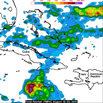
Cristobal Becomes A Hurricane

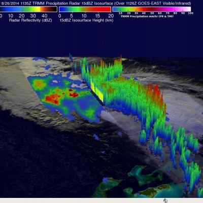
Tropical storm Cristobal was upgraded to a hurricane yesterday evening at 8:20 PM (August 26, 2014 at 0020 UTC). The TRMM satellite flew above the newly designated hurricane this morning at 1135 UTC (7:35 AM EDT) providing rainfall data used in this image. A rainfall analysis derived from TRMM's Microwave Imager (TMI) and Precipitation Radar (PR) data is shown overlaid on a 1126 UTC GOES-EAST Visible/Infrared image. Cristobal was a category one hurricane with sustained winds estimated to be slightly above 65 kts (about 75 mph) with this view. Cristobal's didn't have a clearly defined eye with

Deadly Tropical Storm Cristobal

Strong winds and flooding associated with tropical storm Cristobal have caused deaths in the Dominican Republic, Haiti and Jamaica. Rainfall data for the first image above was captured by the TRMM satellite on August 24, 2014 at 1150Z (7:50 AM EDT). Tropical depression four was upgraded to tropical storm Cristobal a short time after that TRMM view. The next image uses data received by TRMM a day later on August 25, 2014 at 1230 UTC ( 8:30 AM EDT). Cristobal was a sheared tropical cyclone with a rain free center so a red tropical storm symbol was used to clarify the location of Cristobal's

Tropical Storm Chantal Enters the Eastern Caribbean

Since forming on the night (EDT) of 7 July 2013 in the tropical central Atlantic, Tropical Storm Chantal has continued to race westward at up to 29 mph (~46 kph) and has now entered the eastern Caribbean with sustained winds reported at 65 mph (~100 kph) by the National Hurricane Center. TRMM captured this latest image of Chantal at 02:37 UTC 9 July 2013 (10:37 pm EDT 8 July) as Chantal was approaching the Lesser Antilles. The image shows the horizontal distribution of rain intensity within Chantal. Rain rates in the center of the swath are from the TRMM Precipitation Radar (PR), and those in

TRMM Sees Disorganized Tropical Storm Maria

The TRMM satellite passed over tropical storm Maria on 12 September 2011 at 1249 UTC (8:49 AM EDT). This TRMM pass shows that tropical storm Maria's center of circulation was exposed and displaced well to the west of deep convection. A red tropical storm symbol was overlaid on the image derived from this TRMM pass to show the location of Maria's center of circulation. With this pass TRMM's Precipitation Radar (PR), shown in the lighter swath, scanned directly above the deep convection east of Maria's center. Those data showed that some rainfall in this area was very intense with rates of over

Tropical Depression 08L Forms In The Caribbean

The TRMM satellite had a good daytime view of the tropical wave that was upgraded to the Atlantic Ocean basin's eighth tropical depression on 19 August 2011 at 0300 UTC (18 August 11 PM EDT). An image from TRMM's pass on 18 August 2011 at 1757 UTC (1:37 PM EDT) is displayed above and reveals that the precipitation pattern was getting a little better organized but heavy rainfall didn't cover a large portion of 08L at that time. Tropical depression 08L is predicted by the National Hurricane Center (NHC) to weaken to a remnant low in the next three days while producing rain over Honduras

Tropical Cyclone Forming in the Caribbean

On 18 August 2011 at 0307 UTC (11:07 PM EDT) the TRMM satellite traveled above an area of organized shower activity in the Caribbean Sea that the National Hurricane Center (NHC) forecasts will soon become a tropical cyclone. TRMM's Microwave Imager (TMI) and Precipitation Radar (PR) data show that this tropical wave south of Jamaica contained several areas of convective thunderstorms that were dropping rainfall at the rate of over 40 mm/hr (~1.6 inches). TRMM's PR data show that some thunderstorm towers in this stormy area were higher than 13 km (~8 miles).

Tropical Wave (90L) Forming in the Caribbean

On 26 July at 1435 UTC (10:35 AM EDT) the TRMM satellite passed above a tropical wave in the Caribbean Sea southwest of Cuba. On 27 July this area was given a high (80%) probability of development into a tropical cyclone by the National Hurricane Center (NHC). TRMM's Precipitation Radar (PR) data indicates that a convective tower within this area of disturbed weather reached to heights of over 15 km (~9.3 miles).