Boris

Heavy Rainfall For Mexico & Central America

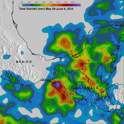
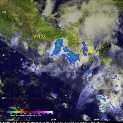
The movement of tropical storm Boris into southern Mexico and a nearly stationary low pressure system in the southern Gulf Of Mexico has been causing heavy rainfall in that area. The TRMM-based, near-real time Multi-satellite Precipitation Analysis (TMPA) at the NASA Goddard Space Flight Center monitors rainfall over the global Tropics. TMPA rainfall totals are shown here for the period May 29 to June 6, 2014. The highest rainfall totals of over 535 mm were analyzed where tropical storm Boris came ashore in southern Mexico. The slow moving low pressure center in the Bay Of Campeche is

Boris Dissipates, Atlantic Disturbance Stengthens

On June 5, 2014 at 0549 UTC (1:49 AM EDT) the TRMM satellite flew above the remnants of tropical Depression Boris and powerful thunderstorms that recently developed in the Gulf of Mexico. Rainfall derived from TRMM Microwave Imager (TMI) and Precipitation Radar (PR) data are shown overlaid on an enhanced infrared image from the GOES-EAST satellite. TRMM found heavy rainfall over Mexico's Pacific coast and with a disturbance in the Gulf Of Mexico (90L). Rainfall was falling at the extreme rate of over 163 mm (about 6.4 inches) per hour in powerful thunderstorms associated with the low pressure

Boris Intensifies, Hits Mexico And Dissipates

Tropical Depression TWO-E was upgraded to tropical storm Boris yesterday at 1800 UTC (11AM PDT) but Boris weakened to a tropical depression after going ashore in Mexico. The TRMM satellite passed above tropical depression Boris on June 4, 2014 at 1457 UTC and collected data used in this rainfall analysis. TRMM rainfall data are shown overlaid on a GOES-EAST enhanced infrared/visible image received at 1445 UTC. TRMM's Microwave Imager (TMI) data show that Boris was still dropping light to moderate rain over southern Mexico in the area of the Gulf Of Tehuantepec. Click on this animation to see a